Axial Planar Cleavage in Folded Slate EarthCache
Axial Planar Cleavage in Folded Slate
-
Difficulty:
-

-
Terrain:
-
Size:  (other)
Please note Use of geocaching.com services is subject to the terms and conditions
in our disclaimer.
The Goal
The goal of this EarthCache is to introduce you to the concept of axial planar cleavage. Hopefully when you're done with this, you'll be able to see it in the rocks and measure it.
SAFETY FIRST:
This EarthCache is a roadcut along U.S. Highway 321. Exercise caution when parking your vehicle and when walking along the roadcut so that you will stay safe from the traffic on the road. There is a driveway at the SE end where you can probably find a place to park.
To help out paperless cachers, the logging requirements are listed here at the beginning. However, you will need to read through the entire listing in order to understand what you're supposed to do.
Tools you will need:
1) your GPSr;
2) a protractor or other way to measure an angle (smartphone apps, clinometer, etc.); and
3) a camera (optional).
To log this EarthCache:
1) Using a protractor or other tool, measure the angle of dip from horizontal for the axial planar cleavage planes; send an email to the cache owner with your answer. Answers within 10 degrees of the true value are accepted. Make sure that you are not measuring the dip of the limbs of the fold or the bedding planes. If the surface you are looking at is folded significantly as you follow it, it's not the axial planar cleavage and you are looking mostly likely at the bedding surface on one of the fold limbs. It's also a good idea to try and measure the axial planar cleavage near the hinge of a fold, because sometimes the cleavage will fan out on the limbs. See below for the explanation of the concepts involved.
2) Also in your email, send your best answer to this question: If the cleavage in the rock had formed BEFORE the rocks had been folded, how would this change the angles of the cleavage planes? How would it look differently?
3) Optional Task: If you are able, post a picture of one or more of the folds & axial planar cleavage from your visit to the site when you log the cache. When photographing rocks, geologists always include something "for scale", meaning that they place something in the photograph to let people know the size of the objects in the picture, like the hammer in the pictures below. This practice is a standard method among geologists of documenting geologic materials with photographs. Geologists often use a rock hammer, hand lens, pocket knife, a ruler, or similar objects for scale. The object you use for scale is up to you, so long as it helps us know the scale of the objects in the picture. Taking good quality photographs to document field work is part of the training of a geologist.
The Rocks
This EarthCache consists of rocks that were formerly shale or mudstone, but are now metamorphosed into slate and deformed from their original shape. Rocks are metamorphosed and deformed by high heat and pressure in the Earth. These rocks are called the Wilhite Slate, which is a member of a group of metamorphosed sedimentary rocks called the Walden Creek Group. This group of rocks was deposited as sediments during the late Precambrian Era (~700-550 million years ago). They remained as undeformed, unmetamorphosed sedimentary rocks for many millions of years. But later, they were deformed and metamorphosed during the Ordovician Period (~460-450 million years ago). It took all of these events and more to shape the Appalachians as we know them today.
The Deformation
As mentioned, the rocks present at this roadcut are deformed. They are deformed in two ways. One way is that the rocks were squeezed into a series of folds from their original flat-lying orientation. Imagine a flat layer that gets pushed on from both ends, causing it to bend & buckle. At various places along this roadcut, you can see that the different layers of the rocks are folded; they are no longer flat planes, but are now curved. Folded rocks can become quite complex, but the geometry of most folded rocks can be described with a few simple features. The hinge of the fold is the area where the fold has maximum curvature, and the hinge separates the two limbs of the fold. 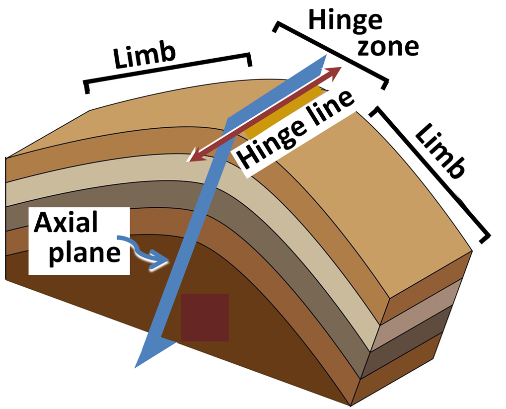 You can see these features labelled on the image on the left (image from Wikimedia Commons). Another feature of folds is called the axial plane. If you are looking at a fold from the side, you can imagine drawing a line from the hinge down the middle between the two limbs, splitting the fold into two halves. That imaginary line traces the axial plane. In the figure on the left, the axial plane is the blue plane in the center of the fold. As you inspect these rocks, you will need to locate a fold (there are many!) and identify the limbs, hinge area, and axial plane.
In addition to being folded, these rocks have been deformed in a second way. The rocks contain a number of parallel planes where the rocks tend to split apart. Geologists call these planes of weakness rock cleavage. Rock cleavage is formed when tiny, flat, mineral grains within a slate are all lined up in the same direction. The rock will tend to break along these planes in between grains because they are weaker parts of the rock. Most slates, like the Wilhite Slate, are highly cleaved. Some slates split so well that they are mined out of the ground and used to make excellent pool tables.
In the rocks at this EarthCache, you should be able to see that the folds and the rock cleavage planes are for the most part closely related. In other words, the folds and the cleavage planes are not in a random orientation. Instead, the geometry of the cleavage planes is lined up with the geometry of the folds. In this case, most of the cleavage planes in these rocks are in fact parallel to the axial planes of the folds. Geologists refer to this as axial planar cleavage. This relationship between the folding and the cleavage indicates that these two kinds of deformation formed at roughly the same time, and not in different events separated by millions of years.
The coordinates should lead you close to the fold in the pictures below. In the image on the right, one of the layers of the fold is highlighted as well as the axial plane.
 |
|
 |
| Fold in Wilhite Slate with axial planar cleavage. |
|
What a geologist sees. |
Note: The highway crew must have come along & done some clearing recently. The fold pictured above has been partially removed (the right side). However, there are lots of rocks and folds along this roadcut.
More Information
The folds in this outcrop have been pictured and discussed in several structural geology textbooks and field trip guidebooks. They are a great place for students of geology to discuss more advanced topics of fold mechanisms. For more information, see discussion surrounding figures 15-26 and 17-1 in Hatcher, Robert D., Jr., 1995, Structural Geology: Principles, Concepts, and Problems, 2nd Ed., Prentice Hall.

Additional Hints
(No hints available.)
Treasures
You'll collect a digital Treasure from one of these collections when you find and log this geocache:

Loading Treasures