BTTHAL é uma equipa, formada por um
conjunto de colegas e bons amigos, funcionários do HAL (Hospital
Amato Lusitano) de Castelo Branco, profissionais de Enfermagem da
(UCIP) Unidade de Cuidados Intensivos Polivalente e da Equipa
VMER/INEM (Viatura Médica de Emergência e Reanimação do INEM) deste
Hospital. O grupo tem por base a prática de BTT, no entanto abraça
uma variedade de actividades desportivas outdoor, como é o caso do
Geocaching. Possuidores de dois blog’s na web
(http://btthal.blog.com
e http://btthalonboots.blogspot.com), aconselhamos a visita dos mesmos onde são relatadas e
documentadas com fotografia as diversas actividades da
equipa.
BTTHAL is a team, formed by a
number of colleagues and good friends, officials of the HAL
(Hospital Amato Lusitano) of Castelo Branco, professionals in the
Nursing (UCIP) Intensive Care Unit of and Team VMER / INEM
(Emergency Medical Car) of this Hospital. The group is based on the
practice of mountain biking, however embraces a variety of outdoor
sporting activities, such as
Geocaching. We have two
web blog's (http://btthal.blog.com and http://btthalonboots.blogspot.com), you are
advised to visit them where they are reported and documented with
photography the various activities of the team.
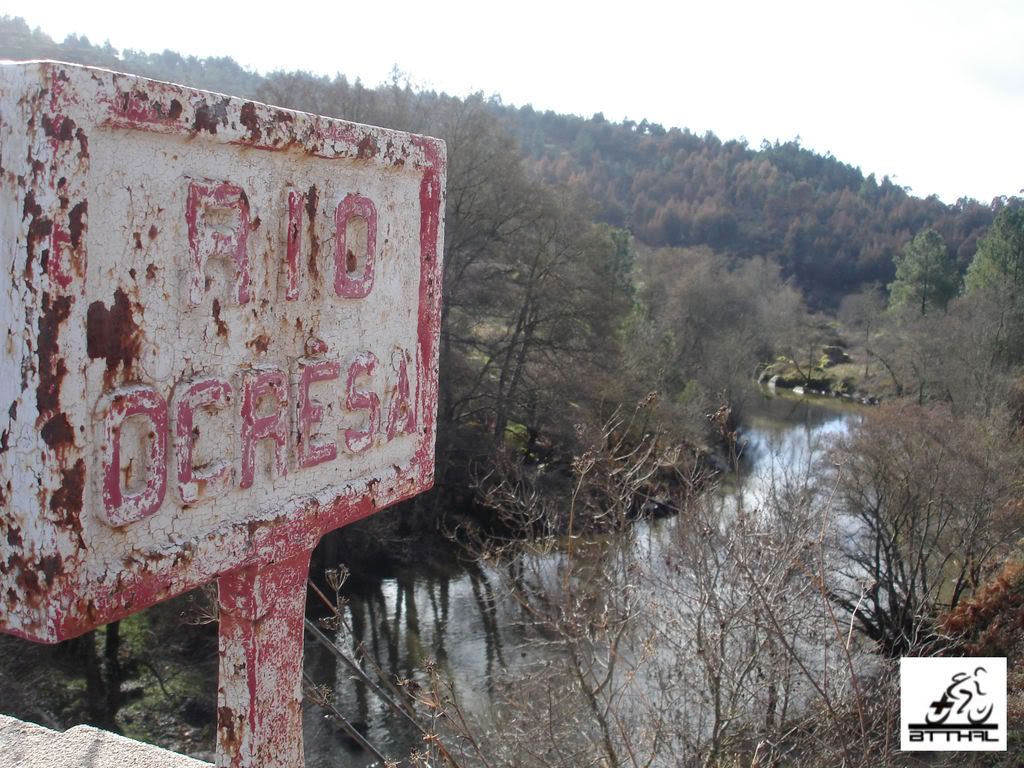
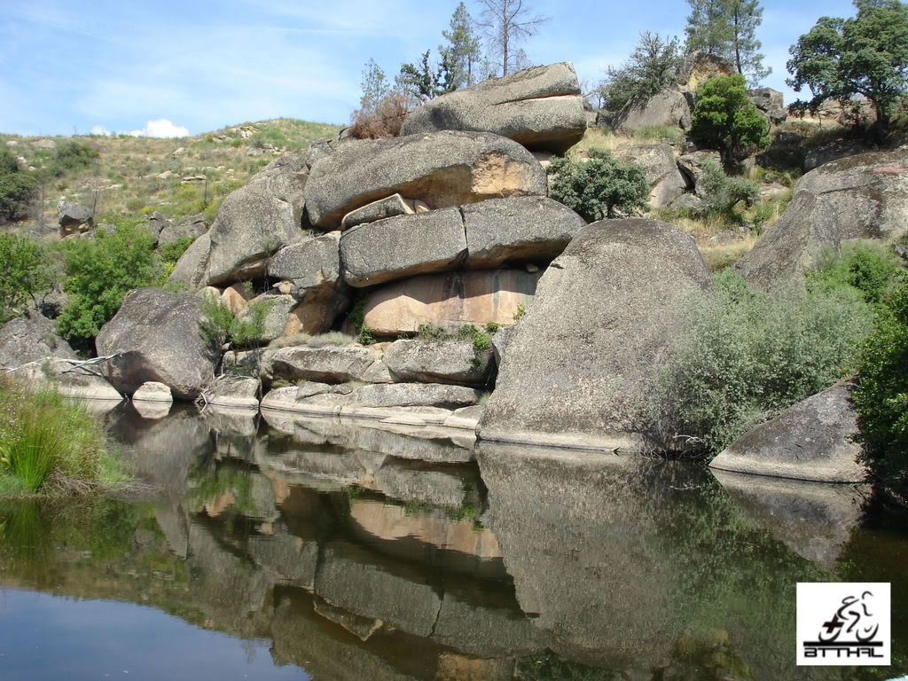
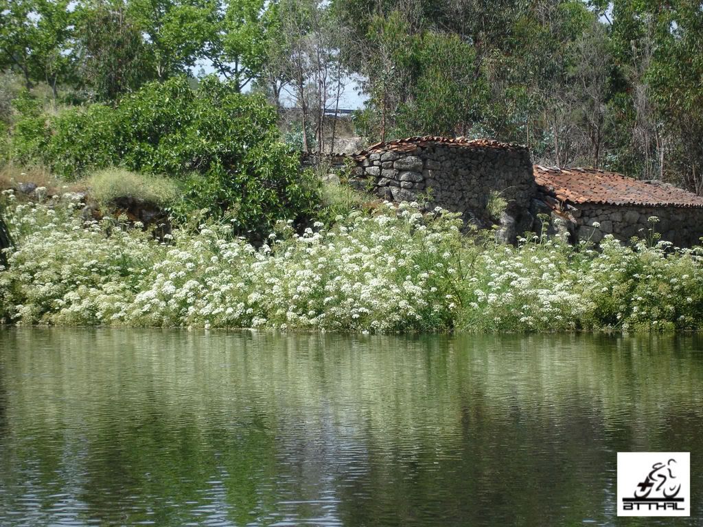
O Rio Ocreza: O
Rio Ocreza nasce na vertente sul da Serra da Gardunha, percorre
cerca de 80 km em plena Beira Baixa e desagua próximo da Amieira do
Tejo, engrossando este grande rio internacional. Ocreza significa
"rio do ouro" o vil metal soberbamente explorado pelos lusitanos e
os romanos no seu leito e cujos vestigios deixaram espalhados ao
longo das suas margens - lagariças e monumentos funerários, ainda
hoje observáveis.
As margens deste belo rio foram ao longo de gerações, um palco
previligiado para a fixação humana, ainda hoje constatável pelas
inúmeras azenhas ou moinhos, estrategicamente colocados à beira do
rio e protegidos por represas. Estes moinhos tiveram um papel
económico importante na produção da farinha, elemento
imprescindivel para o fabrico de pão, o alimento principal de
muitas familias que por aqui viviam. Complementarmente ao moinho
existia normalmente uma casa de habitação, hortas, capoeiros e
pocilgas que enriqueciam a mesa destas familias. O peixe pescado
nas margens contribuia igualmente para enriquecer as refeições, em
tempos de "magros rendimentos".
Mais recentemente, as suas verdejantes margens foram muito
procuradas, sobretudo nos dias cálidos de verão, para actividades
de lazer, como a natação, piqueniques e pesca desportiva.
The
Ocreza River: The Ocreza river borns in the southern
part of Sierra Gardunha, covers about 80 km in full Beira Baixa and
flows near Amieira do Tejo, in this great international river.
Ocreza means "river of gold" the vil metal and superbly exploited
by the Lusitanian and the Romans in his bed and whose traces left
scattered along its shores - mills and funeral monuments, still
observable.
The margins of this beautiful river were over generations, a stage
previligiado for human settlement, still notable the many water
mills, strategically placed by the river and protected by dams.
These mills have a major economic role in the production of flour,
essential element in the manufacture of bread, the main food of
many families who lived there. In addition to the grinder there
normally a house for housing, gardens and stables that forfill the
table of these families. The fish caught on the banks helped also
to enrich their meals, in times of "lean income."
More recently, their green margins were much sought, especially on
warm summer, for leisure activities such as swimming, picnic and
fishing sports.
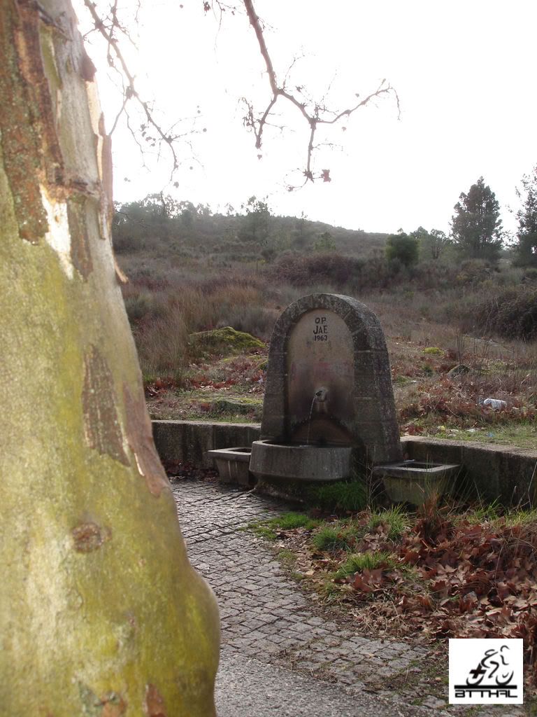
A Fonte: Esta fonte
foi outrora um ponto de encontro de viajantes, caçadores e
pescadores que por ali paravam para matar a sua sede e fome,
sentados nas mesas e bancos existentes, à sombra dos imponentes
plátanos que ali existem. Nas décadas de 60, 70 e 80 foi igualmente
importante para o fornecimento de água, quando em tempo de Verão as
torneiras das populações de Castelo Branco e Salgueiro secavam por
falta de água nas albufeiras públicas. Do lado de lá da estrada
ainda existe o Café das Tabuinhas, um agradável café à beira rio
plantado, inteiramente construido em tábuas e que hoje se encontra
em avançado estado de deterioração, servindo apenas de residência a
uma familia humilde.
The Source: This
source was once a meeting point for travelers, hunters and
fishermen who stopped by there to kill their hunger and thirst,
sitting at the tables and banks existing in the shadow of the
imposing plaintains that there exist. In the early 60, 70 e 80 was
equal important to provide water in the summer time when the taps
of populations of Castelo Branco and Salgueiro dry out for lack of
water in reservoirs public. From the side of the road there still
exists the Tabuinhas Café, a pleasant riverside planted to coffee,
entirely built in boards, which today is in advanced state of
deterioration, serving only of residence to a humble
family.
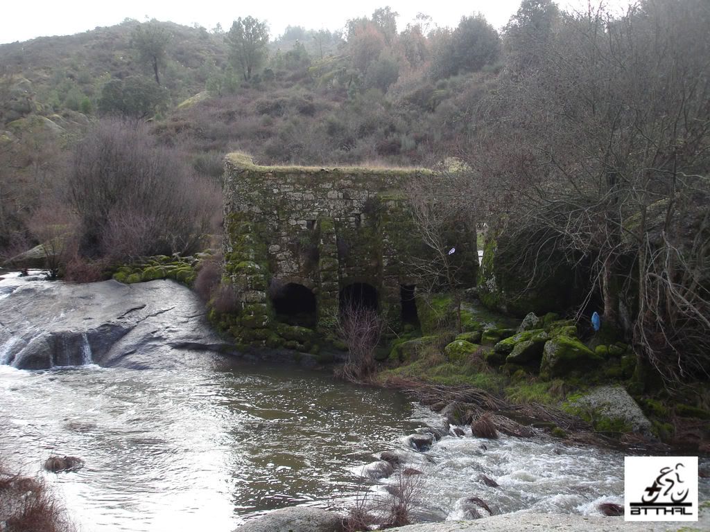
A Cache: A GeoBTTHAL 3 (GB3) é na sua
essência uma cache de contrastes. O local escolhido para
implantarmos a micro-cache que fornece as coordenadas finais - A
Fonte, está hoje votada ao abandono e descuido dos que por lá
passam, evidenciando francos sinais do desrespeito humano pela
Mãe-Natureza - degradação e lixo abundam por ali. Um excelente
sitio para por em prática um dos mandamentos do geocaching - "
Cache In, Trash Out. Já a cache final é um hino à natureza em todo
o seu esplendor. Distando algumas centenas de metros da
micro-cache, está implantado num local onde podemos simplesmente
sentar e apreciar o canto dos pássaros, o murmúrio do rio na
represa, o sussurro do vento nos pinheiros e imaginar como viviriam
as pessoas que habitaram aquela azenha. Vão, fotografem e
apreciem... Um espectáculo!
The
Cache: The GeoBTTHAL 3 (GB3) it's in essence a cache
of contrasts. The venue were we put the micro-cache that provides
the coordinates final - The Source, is now doomed to abandonment
and neglect of which there are, showing signs of disrespect human
francs by Mother-Nature - for degradation and garbage abound there.
An excellent site order to implement one of the commandments of
geocaching - "Cache In, Trash Out". Already the final cache is an
ode to nature in all its splendour. A few hundred metres from the
micro-cache, is located in a place where we can simply sit and
enjoy the singing of birds, the dam murmury of the river, the wind
blow in the pines and imagine the people who inhabited that mill.
Go, shoot the digital and appreciate ... It's a
show!
 Conselhos:
 A cachada implica andar por
terrenos irregulares e nas proximidades de uma estrada. Dai
deixamos alguns conselhos que consideramos úteis:
-- Evite fazer a cache à noite - lembre-se está no meio da
natureza!
-- Tenha cuidado com o trânsito da estrada - Caminhe com segurança
e estacione sem perturbar!
-- Use calçado e vestuário cómodo e resistente - vai caminhar cerca
de 400 metros!
-- Tenha cuidado com o acidentado do terreno - rochas escorregadias
e a proximidade do rio podem causar acidentes - Previne-se!
-- Particular atenção ás crianças! Elas vão gostar do local mas
mantenha-as bem vigiadas - o perigo espreita!
-- Agradecemos que não publiquem fotos da microcache.
Advice: The cache implies floor
by irregular and land near a road. We left some advice consider
useful:
-- Avoid making cache at night - remember is in the midst of
nature!
-- Beware of the transit road - Walk safely and without disturbing
park!
-- Use comfortable and resistant footwear/clothing - will walk
about 400 meters!
-- Be careful with the rough terrain - rocks slippery and the
proximity to the river can cause accidents - Prevents up!
-- Particular attention to the children! They will like the place
but keep them well watched - the danger watch's you!
-- Please, do not publish photos from the
inicial container.