Red Crater, Tongariro EarthCache
-
Difficulty:
-

-
Terrain:
-

Size:  (not chosen)
Please note Use of geocaching.com services is subject to the terms and conditions
in our disclaimer.
Located on the Tongariro crossing trail near the highest
point of Mt Tongariro
Red crater is one of several active craters on top of Mt Tongariro
in the Tongariro National Park. It last erupted in 1850.
The crater itself was formed some 3,000 years ago and it has been
very busy since with evidence of some spectacular lava flows down
into the floor of South crater and back into the Oturere
valley.
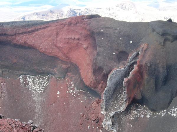
This spectacular and unusual volcanic feature is a classic lava
dike which formed when lava flowed out of the crater. This lava
flow lost its "mojo" before it cooled and then it flowed back into
the crater leaving behind a tube which has been exposed by later
eruptions. The crater in which it is found has striking deep red
and brown/green coloured crater walls which is caused by extreme
heat sintering and oxidising the iron content of the rocks.
The feature is clearly visible from the safety of the Tongariro
Crossing trail. Hikers should remain on the trail as the crater rim
is fragile and loose.
The Tongariro Alpine Crossing is a must do for many outdoor
tourists and locals alike. It takes 5-6 hours to complete the 18km
hike... cache stops excluded. Buses depart from Turangi, National
Park, Ohakune and from Adventure Headquarters on SH 47. The buses
deliver eager hikers to the Mangaetepopo Valley. Bookings may be
necessary so enquire at the local information Centres. The buses
start returning from Ketetahi carpark at 3pm, 4:30 pm and
6:30pm
To access this cache, a reasonable level of fitness is essential as
is good footwear, boots not runners unless you are an experience
mountain runner. It is not suitable for sub teen kids or even most
teenagers unless they are seasoned hikers and capable of this
distance. Visitors must be prepared with food, plenty to drink,
warm gear, hats, gloves and raincoats. The weather can change
suddenly from warm sun to a howling gale and cold cold sleet or
snow. It is an Alpine environment so care and common sense are
essential for the 18 km hike
To log this cache, send the answer to the following question to the
owner: What is the elevation at the point on the trail that the
feature is first visible?
There are many other amazing features to be seen on this trail. The
start of the walk takes visitors past Pukekaikiore which is a
classic dome lava extrusion with spectacular vertical jointing on
its exposed cliffs and some great rock climbs to be had. Next stop
is the beautiful soda springs, beyond that on the flanks of Mt
Ngauruhoe can be seen recent black lava flows from 1949 and 1954,
both recently becoming colonised by plant life. Onward and upward
via the aptly named Devils Staircase to the summit of Tongariro
which comprises multiple craters and vents to the cache feaure.
Beyond that down a loose scree slope (Boots ARE essential) are to
be found the beautiful Emerald lakes which derive their colour from
the sulphur vents heating them. On the downward journey the trail
passes by Ketetahi springs which has had to be returned to private
ownership due to damage by too many unthinking visitors and
numerous scald injuries. The beech forest below is just gorgeous
and near the end of the trail is a spectacular waterfall from water
emanating from Ketetahi spring above.
Please follow the: 
Additional Hints
(No hints available.)