To avoid confusion with an existig GeoCache, The Old
Mine, all the clues in Glen Sannox for this cache are on the
opposite side of the Sannox Burn.
In the late C18th the Duke of Hamilton’s factor on the island,
John Burrel, initiated a series of schemes to reorganise land
tenure on the island and provide a diversify employment
opportunities with the purpose of making the Duke’s Arran estate
more profitable. In the decade from 1772 he amalgamated the runrig
system of agricultural holdings into small farms and started a
number of extractive industries.
Although the presence of Barytes veins (Barium Sulphate, BaSO4)
was known in Glen Sannox from at least the 1770s actual mining of
the ore only began in 1840. For 24 years a small scale operation
was run with a vertical shaft sunk either side of the river and the
mineral vein followed 30m below the riverbed. Only a couple of
hundred tons of ore were extracted each year and sold to paper mill
in Glasgow where it was used as a filler in the manufacture of
higher quality paper. Unfortunately the mine was closed by the 11th
Earl of Arran in 1862 along with the quarry at Corrie as they
spoiled the solemn grandeur of his shooting estate.
Work to reopen the mine commenced in 1918 with the construction of
a self acting narrow gauge railway down Glen Sannox to a concrete
hopper, the back wall of which can still be seen by the entrance to
the gravel pit by the side of the road. From there the crushed
barytes was taken by a tramway across the Sannox Burn to a wooden
jetty in Sannox Bay where it was loaded onto coasters for onward
transport to Glasgow for milling as an industrial filler. The mine
workings were greatly extended and annual production was in the
region of 10,000 tons per year. The new workings extend northwards
up towards Cnocan Donna along the line of a tramway, as well as
sinking additional shafts on the south side of the Sannox Burn.
Water power was used extensively and just above the old processing
works there is evidence that the course of the river has been
changed, although there is no documentary evidence whether this was
to construct a lade or to gain access to the barytes vein in the
river bed.
Production ceased just before WWII despite there being
considerable proven reserves. Maintenance and development work
continued into the early 1950s production was never restarted.
There are now no British mines working vein deposits of barytes,
whose principle use is as drilling mud because of its stable
chemistry and high specific gravity. In mines like Sannox the
barytes had to be crushed and then sorted to remove the bedrock
into which the mineral veins had pervaded (Old Red Sandstone
conglomerates at Sannox). The Foss mine, near Aberfeldy, where the
barytes occurs as beds of almost pure barytes up to 8m thick, now
meets practically all the domestic demand for barytes.
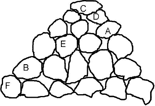
You will find the cache you will have to solve the simple
arithmetical task set by the Sannox miners. If you look at the
stack of barytes boulders below, by substituting numbers for
letters and using simple maths (it all adds up or subtracts down),
you will be able to read off the missing figures to the latitude
and longitude you need:
55° 39.Fxx’ North
5° 10.xxx’ West
- the first two numbers of the bus route to from Brodick to
Blackwaterfoot
- one less than the number of stepping stones across the river
(not counting the two attached to the bank)
- take the bearings to the three navigation beacons the correct
values will give you the solution for C: 031°/239°/260° = 120;
024°/255°/276° = 116; 020°/247°/256° = 112
- = XY where X is the number of horizontal bars in the fence and
Y = A
- the numerical value of the final letter of this piece of
industrial archaeology
- the number of vertical threaded rebars more than 7cm high
protruding from the concrete plinth
