Ken recalls:
I lived in Oakwood, years ago, in an old house - so old it pre-dated electricity, and the original electrical connections were Edison-era direct-current lines. It was a cozy feeling, strolling down the streets of jigsaw gothic Victorians, but there was a haunting quality, too, as in any place of so much memory. The atmosphere is redolent of age in Oakwood, and in no place is that more true than in Oakwood Cemetery.
Founded in 1869, Oakwood Cemetery well reflects the aesthetics of its time, from the masterful sepulchral stonework to the well-mannered landscaping. Walk among the stones and you will be entranced by the peaceful beauty of the place. But the stories told in its stones predate this final peace. There are tales of war, of murder, and, always, the tragedy of death.
Six virtual cache sites, described below, will introduce you to some of these tales. Taken together, they will lead you to a physical cache in a nearby park. Please be respectful of those we remember in this place. And please remember that the cemetery closes at 5 p.m.
Preliminaries
At each of the first six stages below, in addition to learning something about North Carolina's past, you will receive a number. You can then enter those numbers on the appropriate blank below:
A=____ B=____ C=____ D=____ E=____ F=____
The number you receive at each stage will help guide you to the next stage. Depending on how well you know your history - and Oakwood Cemetery - you may be able to find some of these stages without using the coordinates. Regardless, you will still need all these numbers to find the physical cache at Stage 7, and the only way to get those numbers is to visit Stages 1-6.
It would be helpful to bring along a calculator, and certainly a pad of paper and a pen or pencil. It would also save time if you pre-entered the information given below for each of the seven stages into your GPSr, so you would only need fill in the blanks.
Stage 1
N 35o 47.136
W 78o 37.679
Despite strong Union sentiments among many in the State - particularly in the mountains - North Carolina eventually joined the Confederacy, and wound up sacrificing more men to the cause than any other state. 125,000 North Carolina men served in the Confederate armed forces, and more than 20,000 of those men died or were wounded in service. After the war, over 2,000 of those who died were disinterred from a Raleigh cemetery by orders of the Union Army, which wanted the land for a national cemetery. A local community leader (whom you will learn more about in Stage 3) donated two acres of land for their re-interment, thus creating the Confederate burial grounds that served as the core for Oakwood Cemetery. Here you will find the graves both of those who died in the war and of Confederate veterans who died thereafter.
The Stage 1 coordinates take you to a prominant landmark in the Confederate cemetery. Just uphill from this point - to the east - you'll find two gravestones close to a bench. One of them is for a private from Texas. The two men remembered on these stones died in the same year. Take the last digit of that year as 'A' and you'll be ready to find Stage 2.
Stage 2
N 35o 47.233
W 78o 37.A93
While most of these virtual cache sites were chosen for historical reasons, there are two here - this one, and Stage 5 - that were chosen purely for aesthetic ones. When you see the alabaster angel in repose at this stage, you'll see why we chose her. This monument is very close to a bench honoring a man whose first name was Wade. The bench and angel are in the same plot. Adjacent to this plot, to the south, is a plot with some crosses marking its graves. Count the crosses, and you'll have the number B.
Stage 3
N 35o 47.208
W 78o 37.5(B+1)5
They were one of the original 300 Jewish families in the United States, and one of the few of Ashkenazic descent. Father Jacob spoke Yiddish and Hebrew, was renowned as a Jewish scholar, and kept a kosher household - no small feat in late 18th/early 19th century North Carolina. His sons, however, would leave the faith. The eldest, Moses, became an attorney in Raleigh, and married into one of the city's first families. They were Episcopalian, and so his children were baptized in that church. Moses' brother George followed his sibling's course - coming to Raleigh to study law under Moses, and joining the Episcopal Church. George became very prominent in 19th century Raleigh - serving on the building committee for Christ Church, and on the board of St. Mary's College. He helped establish Rex Hospital. And he was the man who donated two acres for the Confederate Cemetery. He went on to establish and serve as first president of the Oakwood Cemetery Association.
Interestingly, though he gave up his Jewish faith, he apparently maintained some loyalty to his heritage, for he agreed to the creation of a Jewish burial ground within Oakwood Cemetery. If you are interested, you may visit this section, which is located near the Confederate burial grounds (if someone sends me the coordinates, I'll post them here).
George's wife, Margaret, has a monument with a crown on the back. Count the stars on this crown, and you'll have the number C.
Stage 4
N 35o 47.126
W 78o 37.(C-2)10
This stage leads you to a governor's grave. That this leaves open seven possible sites should indicate the status of Oakwood Cemetery. This particular governor is remembered for a number of reasons - he was a UNC president, for one thing, and there's a county named for him, for another. But he's probably best known today for his connection with Frankie Silver.
Frankie Silver was a young woman hanged in 1833 for the murder of her husband. Her story has since been the subject of ballads, books, and even a ballet, though folklorists (some of them, anyway), dispute that "the Ballad of Frankie Silver" provided the basis for the familiar "Ballad of Frankie and Johnny." In any case, her husband's name was Charlie, not Johnny. The governor refused to pardon Frankie Silver, despite the petitions of hundreds of people, and despite evidence that Charlie had physically abused Frankie.
Later, during the governor's tenure as president of UNC, his daughter Ellie married the commander of the Union troops then occupying Chapel Hill. Students protested this union by ringing the campus bell loudly throughout the service, and hanging the couple in effigy.
The governor's family plot is marked with a low stone boundary, set with periodic stone posts. How many trees do you find within this perimeter? That number is D.
Stage 5
N 35o 47.126
W 78o 37.4D9
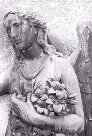
This is the other aesthetically chosen site. In memory of a child, the monument is a stone angel, missing one hand. How many letters are there in the girl's first name? The answer to that question is E.
Stage 6
N 35o 47.081
W 78o 37.4E0
Until the 1990s, The News & Observer was a family-owned paper, and that family's plot is the subject of this stage. Josephus started the N&O, and his statue still stands in the park across from the newspaper's offices downtown. Today, he may be best known as the source of the phrase "cup-a-joe." Apparently, when he was Secretary of the Navy (1913-1921), he replaced the sailors' ration of alcohol with a dose of coffee, which they then derisively called a "cup of Josephus." He might better be recalled as a Progressive who advocated public support for education, as reflected in the naming of a Raleigh middle school in his honor.
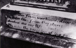
Read the plaque on the monument honoring Josephus. Then turn around. You will now be facing the stones of two girls who died quite young. For one, there is a coincidence between the child's age at death and the year of her birth (referring only to the last two digits of the year). Take the last digit of this number, and you will have F. [NOTE - 9/27/03: The birthdate is hard to read on this stone. At first glance, it looks like an exact coincidence; upon further inspection, it appears off by one. To avoid any confusion, I'm adding this bit of information - It's the stone on the right, of the two.]
How to Find the Physical Cache
You will now use the numbers A-F to find the coordinates for Stage 7, where all three digits after the decimal for both latitude and longitude are missing.
Step 1 - Find the Latitude
Take the numbers after the decimal point that we started out with at Stage 1: 136. To this number, you will ADD the quantity determined by the following formula:
|
(A+B+C)x10
+ (D+E+F)x13
?
|
The number you get by adding the amount from this formula to 136 is G.
Step 2 - Find the Longitude
Take the numbers after the decimal point that we started out with at Stage 1: 679. From this number, you will SUBTRACT the quantity determined by the following formula:
(By the way, in case my HTML superscripting doesn't work for you, that's E squared on the first line.)
The number you get by subtracting the amount from this formula from 679 is H.
Stage 7
N 35o 47.G
W 78o 37.H
For this stage, you will be leaving the cemetery. Please note that the two exits are both on Oakwood Avenue, and the east exit is often closed, so you will most likely leave as you came, via the west exit onto Oakwood Avenue. From here, you can either walk or drive. As you'll see, it's not far.
The cache is fairly small - approximately 5" x 5" X 3". I would have gone micro, but I wanted room for travel bugs. If you're dropping off a travel bug, please take what you must to make room (aside from the cache log and pen!). Initial contents of the cache include a Loreena McKennitt tape, a Canadian toonie and loonie ($2 and $1 coins), a geocaching.com static window decal (logo only), two lovely black-and-white photos Jen took of Oakwood monuments, a scented votive candle, two hand-made ceramic beads, a Carolina Hurricanes antenna flag, and an Appalachian Trail map for the Pedlar Ranger District in George Washington National Forest.
By the way, this site offers a great cache-in/trash-out opportunity. We took out a fair amount of trash when we set up the cache, but there's bound to be more. We encourage you to bring garbage bags for the purpose. Again, thanks! We hope you enjoy this cache.