Ervedosa
[PT] Ervedosa é uma freguesia pertencente ao concelho de Vinhais, distrito de Bragança. Situa-se na margem esquerda do rio Tuela. Pertencem a Ervedosa as aldeias de Falgueiras e Soutilha.
[EN] Ervedosa is a parish belonging to Vinahis Municipality and Bragança's district. It is located on the left bank of the river Tuela. The villages of Falgueiras and Soutilha belong to Ervedosa.
As Minas | The mines
[PT] As minas de Ervedosa começaram a sua actividade em 1908, por intermédio de uma empresa Belga (Société des Mines d'Étain d'Ervedosa), que explorava tanto no subsolo como a céu aberto. Após 9 anos, a exploração foi abandonada, tendo sido recomeçada em 1920 por uma empresa Inglesa (Ervedosa Tin Mines). Essa empresa recuperou a lavaria contruída pela empresa Belga e construiu outra na margem esquerda do rio Tuela que passa mesmo ao lado das minas. Contudo, poucos anos depois a actividade mineira voltou a parar, tendo apenas começado em força por volta de 1928 quando a concessão foi comprada por antigos funcionários. Em 1938, as minas passam a denominar-se "Couto Mineiro de Ervedosa", que compeendia as minas da Borralheira, do Pereiro e do Alto do Vale da Veiga, passando assim, com estas três minas congregadas a ser um dos maiores produtores de cassiterite. Até 1965 foram retiradas da mina cerca de 6000 toneladas de estanho e trióxido de arsénio (As2O3). A partir de 1959, verificou-se um empobrecimento da mineralização, levando a uma exploração maioritariamente a céu aberto e nos aluviões do rio Tuela. O material dos desmontes subterrâneos era transportado pelas galerias até à entrada da mina e depois levado em vagonetas para o exterior até um silo na lavaria. Na lavaria, era triturado e depois sujeito a vários tratamentos (ustulação, lavagens, flutuação em mesas, flutuação por espumas, lavagem electromagnética...) para conseguir separar a cassiterite do arsénio.
[EN] Ervedosa mines began operations in 1908, through a Belgian company (Société des Mines d'Etain d'Ervedosa), which exploited both open pit and underground techniques. After nine years, the mine was abandoned, and only resumed in 1920 by an English company (Ervedosa Tin Mines). This company restored the old washing facility constructed by the Belgian company, and built a new one on the left bank of the river Tuela, which passes right next to the mine. However, a few years after, the mining stopped once again, having only begun working constantly by 1928 when the lease was bought by former employees. In 1938, the mines became known by "Couto Mineiro de Ervedosa", joining three distinct mines (Borralheira, Pereiro and Alto do Vale da Veiga), and with these becoming a major producer of cassiterite. Until 1965, 6000 tonnes of tin and arsenic trioxide (As2O3) were mined from this site. From 1959, there was a depletion of the mineralization, leading to an open pit mining and disregard for underground prospection.
The ore was transported by underground galleries to the mine entrance and then taken in wagons to the outside to a silo. From there it was taken to the wash site, where it was crushed and then subjected to various treatments (roasting, washing, table flotation, foam flotation, electromagnetic washing ...) to be able to separate the arsenic from the cassiterite.
in "O Passado Mineiro e o Presente, na Região de Rebordelo, Ervedosa e Murçós"
Elisa Preto, Paulo Favas & Nuno Figueiredo
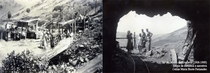
[PT] Fotos da mina em actividade. 1 - Lavaria. 2 - Saída de uma das galerias principais.
[EN] Photos of the mine when it was running. 1 - Washin facilities. 2 - Exit of on of the main galleries.
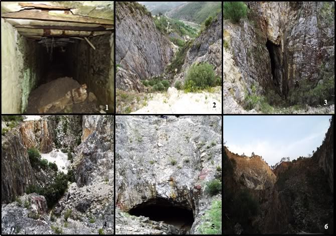
[PT] Fotos actuais da mina. 1 - Local de entrada dos vagões. 2 - Vista do topo da mina. 3- Buraco de acesso às galerias. 4 - Vista superior da entrada principal. 5 - Entrada principal para as galerias. 6 - Vista para o topo da mina.
[EN] Recent photos of the mines. 1 - Wagon entrance. 2- View from the top of the mine. 3 - Entrance to the galleries. 4 - View over the main entrance. 5 - Main entrance to the galleries. 6 - View to the top of the mine.
Estanho | Tin
[PT] O estanho é um elemento químico com símbolo "Sn", número atómico de 50, pertencendo ao 14 grupo dos metais. Possui uma cor metálica e à temperatura ambiente é sólido. Este metal é usado desde a era do Bronze, 3000 AC, e é 49 elemento mais abundante na crosta terrestre. A mineração de estanho não se faz de forma directa, o estanho tem que ser extraído de vários minérios, sendo a cassiterite (SnO2) a fonte mais abundante, e a que foi retirada das minas de Ervedosa. A cassiterite possui uma cor que varia do preto ao castanho e finalmente vermelho escuro (sujo), sendo a conformação mais abundante a de filão vertical. Na cassiterite costumam-se formar cristais tetraédricos de tamanho inferior a 10 mm . Os maiores produtores de estanho a nível mundial são a China a Malásia e o Peru. Actualmente as aplicações do estanho são bastante diversificadas, contudo metade do estanho extraído serve para solda. Serve também para fazer revestimentos, nomeadamente a latas de refrigerantes e comida, e ainda criar outras ligas bastante interessantes. O estanho é ainda utilizado por artistas para fazer peças artesanais. Pode ainda ser usado como um eléctrodo negativo em pilhas de lítio e ser adicionado ao fluor para ser introduzido em pastas de dentes, entre muitas outras aplicações.
[EN] Tin is a chemical element with "Sn" symbol, atomic number 50, belonging to group 14 of the metals. It has a metallic color and at room temperature is solid. This metal is used since the Bronze age, 3000 BC, and is the 49th most abundant element in the Earth's crust. Tin mining is not done directly, tin has to be extracted from various ores, and the cassiterite (SnO2) is the most abundant source, this ore was mined at Ervedosa mines. Cassiterite's color can vary from black to brown, and finally a very dark red. The most usual conformation is in vertical veins. Cassiterite usually forms small cristals, usualy under 10 mm. The largest producers of tin in the world are China and Malaysia and Peru. Currently tin has quite a numer of applications, but half of the total production serves as solder. Tin also is used to make coatings, for soda cans and food, and also to create very interesting metallic alloys. Tin is still used by artists to make handicrafts. It can also be used as a negative electrode in lithium batteries and be added to the fluoride to make toothpaste, among many other applications.
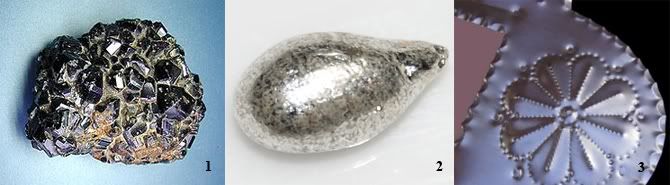
[PT] 1 - Cassiterite. 2 - Gota de estanho. 3 - Trabalho artesanal feito com estanho.
[EN] 1 - Cassiterite. 2 - Tin drop. 3 - Crafts with tin.
A cache | The cache
[PT] Para chegar às coordenadas desta cache recomendo começar o percurso a pé ou de 4x4 no waypoint "Start Here" e seguir a estrada de terra até ao waypoint "Parking", onde devem ficar todos os veículos. A partir daí é seguir a pé até às coordenadas da Earthcache. Aí terão à vossa frente a entrada principal da mina. Para poderem logar esta Earthcache devem responder às seguintes questões:
1. Qual a largura da entrada da mina?
2. Qual a cor predominante das rochas do tecto dentro da mina?
3. Entra na mina à tua frente, lá dentro, do lado esquerdo verás incrustações verticais. De que mineral se trata?Consegues identificar cristais nas incrustações?
Opcionalmente podem enviar uma fotos vossas com o GPS na mão nas coordenadas publicadas.
As respostas devem ser enviadas por mail para mim através do geocaching.com, que prontamente responderei com autorização para fazer o log. Não coloquem respostas às perguntas nem fotos reveladoras de respostas nos vossos logs.
Fotos dos locais são benvindas!
ATENÇÃO
Para fazer esta cache não precisam de visitar os waypoints "Hole" e "Mine Entrance", que dizem respeito a um buraco vertical com acesso à galerias e uma outra entrada da mina, respectivamente. São apenas pontos de interesse, mas caso façam esta cache com crianças pode-se tornar perigoso. Nenhuma das entradas da mina permite explorar o subsolo, pois quando a mina foi desactivada, as entradas foram tapadas algumas dezenas de metros depois da entrada.
Boas cachadas!
[EN] To get the coordinates of this cache I recommend starting the journey on foot or 4x4 at the waypoint "Start Here" and follow the dirt road to the waypoint "Parking", where all vehicles must stay. From there, walk to the coordinates of the EarthCache. There you will find the main entrance of the mine. In order to log this EarthCache you should answer the following questions:
1. What the width of the entrance of the mine?
2. What is the predominant color of the rocks forming the ceiling of the mine?
3. Enter the mine shaft in front of you. You will see vertical incrustations, what mineral do you think it is? Can you identify cristals on them?
Optionally you can send a photos holding your GPS at the published coordinates.
The answers should be sent by mail to me through geocaching.com, I will promptly reply with the permission for your log. Please do not reveal the answers or post revealling photos on your logs.
Photos of the mine are welcome!
ATTENTION
To do this cache you don't need not visit the waypoints "Hole" and "Mine Entrance", which are a vertical hole with access to the galleries and another entrance to the mine, respectively. They are just points of interest, but if you seek this cache with kids, it may become dangerous. None of the entries of the mine lets you explore the underground, because when the mine was decommissioned, the entrances were boarded up after a few dozen meters from the entrance.
Happy hunting!
A very special thanks to Daniel Oliveira for the precious help on this Earthcache.