Welcome to the next
edition of Doc.’s Roadside Geology Tour: Jackson
County!
As we wind our way down and around “The Road Less
Traveled” in the back hills of Jackson County,
Hollywood’s greatest secret is about to be
exposed….!
Behold! .....The secret origins of the Yellow
Brick Road! Flying monkeys and errant ruby slippers have been
sighted within this quadrant of the Driftless Zone ….. Oh
My!!!!!
The above listed coordinates will bring you to a brilliant roadcut
in this little sector of the “Driftless Zone” which
exposes the sedimentary history and the beauty of the Cambrian
sandstone that underlies the steep hills and coulees of the region.
This region narrowly escaped the deleterious effects of the last
glacial advance by several miles, but now tells us what’s in
those outlying mounds we just passed through.

The purpose of this EarthCache is to allow you the opportunity
to get up close and personal with the geology at this site.
First, you are looking at an exposed section of a lower
deposition of the Wonewoc Formation. There are no fossils in this
formation as opposed to the prior deposition of the Eau Claire
formation which hosts early marine invertebrate fossils such as
trilobites, brachiopods, crinoids, hyoliths, etc.
Take some time to examine the texture and integrity of the
sandstone wall. Feel and observe the hardness of the rock wall, the
differences in hardness of the brilliant orange sandstone vs. the
lighter or white sandstone. Also note the size and texture of the
sand granules, both in the wall of the roadcut and the eroded sand
on the ground. The cohesive “cementing material”
creating the rock (or stone) has oxidized and is no longer able to
provide the cohesive support for the individual sand grandules.
As you touch and feel the differences between the sandstone of
the roadcut vs. the sand washed down from the eroding/oxidizing
sandstone wall, please visualize the Table Rock succumbing to the
same erosive forces and the dissolution of that fragile structure
with time.
Yes, there will be a test!
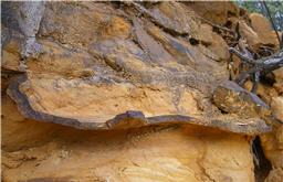 The path of the Yellow Brick Road is
neither straight nor easy. It is known for the tortuous bends and
curves…. Just like all those really dark brown hard twisty
layers found throughout this sandstone formation. These are known
as Liesegang Bands.
The path of the Yellow Brick Road is
neither straight nor easy. It is known for the tortuous bends and
curves…. Just like all those really dark brown hard twisty
layers found throughout this sandstone formation. These are known
as Liesegang Bands.
The hard, dark brown, curved to irregular bands you are seeing
in the road cut rock are deposits of iron minerals and are called
Liesegang bands. These bands are reddish-brown to yellow in color
and are common in cliff-forming sandstones. Much of the red iron
mineralization in these bands are hematite, goethite and limonite.
The source of the iron is the carbonate mineral siderite. But when
siderite weathers, it oxidizes forming the yellow-brown mineral
limonite as well as hematite and goethite. Rainwater penetrated the
rock and oxidized the pyrite to form liesegang bands of red
hematite (Fe2O3) and orange and brown goethite (FeO(OH)).
Liesegang bands are poorly understood chemical structures often
seen in rocks, especially sandstones. They were discovered more
than a hundred years ago by the German chemist Raphael E.
Liesegang, when he accidentally dropped a drop of silver nitrate
solution on a layer of gel containing potassium dichromate, and
concentric rings of silver dichromate started to form.
In sedimentary rocks, Liesegang bands appear well after the
sediment has become a rock (that is, it got compacted and
cemented). Stratification and lamination within the sansdtone are
typically cross-cut by the Liesegang bands; fractures usually have
a more obvious effect on the distribution and orientation of
these.
To claim credit for this EarthCache, please email to
me:
1. Do you see a pattern to the deposition of the iron oxide
banding in the road cut face?
2. How thick is the largest liesegang band in the road cut?
3. Is the liesegang band harder or softer than the surrounding
sandstone wall?
4. Please post a picture to document your visit to this site.
Don’t forget to buckle up for your next stop on
Doc.’s Roadside Tour of Jackson County.