
 Unless you are camping or have a handicap placard you
must take the shuttle bus down into the valley from Mammoth
Mountain. A fee is required. There is no access during the
winter months. Following the bus ride, there is an approximate
1-mile hike down to the falls.
Unless you are camping or have a handicap placard you
must take the shuttle bus down into the valley from Mammoth
Mountain. A fee is required. There is no access during the
winter months. Following the bus ride, there is an approximate
1-mile hike down to the falls.
The informational signs at the falls describe the formation of
the falls. About 75,000 years ago, a volcanic vent about 1
kilometer east of this location erupted rhyodiacite that flowed
into the river valley. The eruption occurred in two pulses, the
second flow covered first insolating the first flow like a blanket.
As a result, the first flow cooled slowly and fractured vertically
while the second cooled quickly and fractured horizontally. These
two flows can be seen in the sides of the canyon below the falls.
As part of the logging requirements, estimate the relative
thickness of each flow that is exposed.
Rhyodiacite is just a technical way of describing the ingeous
rocks. Igneous rocks are typically divided up into four types based
on the amount of silica they contain. Silica is common compound
found in the earth’s crust and is made up of one silicon atom and
two oxygen atoms. For each of the four types of igneous rocks,
there is a volcanic and plutonic name for the rock. Plutonic rocks
form undergound and cool slowly forming interlocking mineral
crystals. Volcanic rocks form on the surface and cool quickly
forming very few if any visible mineral crystals. See
the
USGS Website for a set of graphics. Rhyodiacite is a volcanic
rock that has a silica content between rhyolite and diacite,
somewhere around 68%. Based on the USGS graphs, they tend to be
relatively cool and relatively viscous. Because it is viscous, it
did not let much of the gasses dissolved in the lava escape,
creating a rock with many air bubbles.
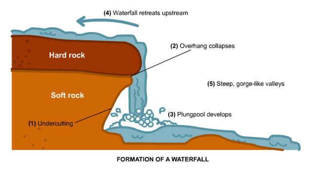 The informational signs also describe the
erosional effects of the river on the lava flows since they
filled the valley. As is typical with waterfalls, the falls
have gradually moved headward (up river) as a result of
erosion. Water hits the bottom of the falls it erodes the rock
underneath the falls, creating an overhand. Eventually, the
overhang breaks off and the entire falls moves upstream a
short distance. The informational sign estimates the distance
the falls have moved upstream since the falls formed. As part
of the logging requirements calculate the rate of headward
erosion of the falls. An animation of this process can be seen
at
classzone.com
(http://www.classzone.com/books/earth_science/terc/content/visualizations/es1305/es1305page01.cfm?chapter_no=visualization)
The informational signs also describe the
erosional effects of the river on the lava flows since they
filled the valley. As is typical with waterfalls, the falls
have gradually moved headward (up river) as a result of
erosion. Water hits the bottom of the falls it erodes the rock
underneath the falls, creating an overhand. Eventually, the
overhang breaks off and the entire falls moves upstream a
short distance. The informational sign estimates the distance
the falls have moved upstream since the falls formed. As part
of the logging requirements calculate the rate of headward
erosion of the falls. An animation of this process can be seen
at
classzone.com
(http://www.classzone.com/books/earth_science/terc/content/visualizations/es1305/es1305page01.cfm?chapter_no=visualization)
Not only has the river eroded headward, but the top of falls has
also eroded down into the lava flows. Initially, the river would
have flowed across the top of the flow, but now it is in an obvious
channel. Once this channel formed, the river has a difficult time
eroding sideways out of the channel, so it becomes insized (stuck)
in the channel and continues eroding down. The final part of the
logging requirement is to estimate the distance down the river has
eroded and calculate the rate of vertical erosion.
Logging requirements:
Send me a note with :
- The text "GC1FE0F Rainbow Falls - Devil’s Postpile NM" on the
first line
- The number of people in your group.
- Estimate the relative thickness of the first flow compared to
the second flow. Base this on what is exposed in the cliffs below
the falls.
- Calculate the rate of headward erosion of the falls (distance
eroded divided by the number of years since the flows filled the
valley)
- Estimate the distance down the river has eroded and calculate
the rate of vertical erosion (distance eroded down divided by the
number of years since the flows filled the valley)
- How does the vertical and horizontal erosion rates
compare.
The above information was compiled from the
following sources:
- NPS informational panels.
-
http://sisgeo.wordpress.com/2007/02/14/formation-of-a-waterfall/
-
http://volcanoes.usgs.gov/Products/Pglossary/VolRocks.html
.
Placement approved by permit from the
Devils Postpile National Monument