 DEUTSCH
Allgemeines
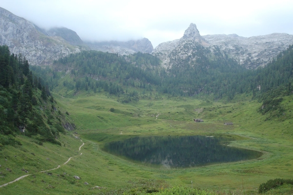
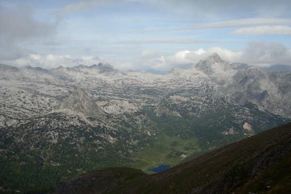
Der Funtensee ist ein Gebirgssee/Karstsee im Nationalpark Berchtesgaden und liegt im Gebirgsmassiv des Steinernen Meeres auf einer Höhe von 1.601 m ü NN. Durch seine lagebedingten Kälterekorde, welche zugleich nicht als repräsentativ für die Umgebung anzusehen sind, gilt er als der "Kältepol" Deutschlands.
Die Fläche des Funtensees beträgt etwa 3,5 Hektar, die Uferlinie ist ca. 780 Meter lang. An seiner tiefsten Stelle ist er rund 5,30 Meter tief. Die durchschnittliche Tiefe liegt bei 2,50 bis 3,00 Meter. Das Wassereinzugsgebiet umfasst circa 10 km² und wird vorwiegend von oberirdischen Zuflüssen wie dem Stuhlgraben (aus dem Südosten, circa 1600 m lang) sowie dem vom Westen kommenden Rennergraben (circa 900 m lang) gespeist. Der See hat zwar keinen sichtbaren oberirdischen Abfluss aber am östlichen Seeufer ist an der Teufelsmühle (Koordinate) hinter einer Felswand ein gurgelndes Geräusch vom unterirdischen Abfluss des Überwassers, zu vernehmen.
Ein wenig oberhalb des Sees liegt das Kärlingerhaus, eine große Alpenvereinshütte, die in der Sommersaison bewirtschaftet wird. Der Winterraum dieser Hütte ist ganzjährig geöffnet und bietet Bergsteigern und Wanderen Schutz.
Im Talkessel des Funtensees wurde bis vor wenigen Jahrzehnten noch Weidewirtschaft betrieben, die allerdings nach 1964 endgültig eingestellt wurde.
Die Herkunft des Namens ist nicht eindeutig geklärt. Mögliche ursprüngliche Bedeutung ist Fontana (Quelle) oder Funken (Forelle). Auf den Wiesen rund um den Funtensee lassen sich in den Sommermonaten zahlreiche Murmeltiere beobachten.
 Entstehung
Die tiefe Senke in welcher der Funtensee liegt ist das Ergebnis kontinuierlicher fortschreitender Erosionsprozesse über einen längeren Zeitraum. In der Geomorphologie wird eine so entstandene Senke als „Uvala“ bezeichnet. Die dabei durch Korrosion (Kalklösung) gebildeten Dolinen (schlot-, trichter- oder schüsselförmige Senke) wurden von einem bis zu 350 m mächtigen Gletscher während der letzten Eiszeit noch tiefer ausgeschürft. Als dieser abschmolz, hinterließ er Grundmoränenmaterial, welches die am Grunde des Sees liegenden Abflüsse abdichtete.
Kältepol
Auf Initiative von Jörg Kachelmann, der vermutete, hier Rekord-Kältewerte messen zu können, errichtete der von ihm gegründete private Wetterdienst Meteomedia eine Wetterstation am Funtensee. An Weihnachten 2001 registrierte die Station mit -45,9 °C die tiefste je in Deutschland gemessene Temperatur; daher gilt der Funtensee als der „Kältepol“ Deutschlands. Am 25. Januar 2000 wurde direkt am Funtensee eine Temperatur von -45,8 °C gemessen, 100 m oberhalb lag die Temperatur bereits rund 27 K (Kelvin) höher. Die sogenannte umgekehrte Baumgrenze (der Wald reicht nur bis circa 100 m oberhalb des Talkessels von den umgebenden Bergen herab, während das unmittelbare Seeufer und der untere Talkessel völlig baumfrei sind) ist keine Folge des Kaltluftsees, sondern durch die Nutzung als Almweide zu erklären. Im heißen Juli 2006 registrierte die Wetterstation am Seeufer -0,5 °C und war somit Deutschlands einzigster Ort mit Nachtfrost.
[Quelle: http://de.wikipedia.org/wiki/Funtensee]
Zwei wesentliche Faktoren spielen für diese Temperaturrekorde eine wichtige Rolle. Zum einen muss die Senke möglichst tief sein (die Funtensee-Doline ist ca. 75 m hoch), wodurch die warme Luft sehr schnell entweichen kann. Eine weitere Voraussetzung ist, dass die nächtliche Abkühlung nicht durch Winde, Wolken oder Nebelfelder behindert werden kann. Die abgekühlte Luft kann über die glatte Schneedecke im Winter ungehindert in die Senke abfließen und wird durch den Mangel an Sonneneinstrahlung nahezu unverändert im Talkessel gelagert.
Cache
Der Funtensee ist über mehrere Zustiege und Wanderwege erreichbar. Ausführliche Beschreibungen gibt es in der Rubrik Anfahrt & Aufstieg zum Funtensee.
Um diesen Cache zu loggen müsst ihr mir anhand der folgenden Fragen und Aufgaben verifizieren, dass ihr tatsächlich am kältesten Ort Deutschlands gewesen seid. Kein Couch-Caching!!!
- Begebt Euch zum unterirdischen Abfluss des Sees (Teufelsmühle – siehe Koordinate) und beschreibt mir diese kurz (evtl. Besonderheiten). Hier kann man das Wasser unterirdisch rauschen hören!
- Am süd-östlichen Ufer des Sees befindet sich die Wettermeßstation, sie ist Teil welchen Programmes? (Schild an der Station, gesucht ist ein Wort, bitte den genauen Wortlaut!)
- Ermittelt den Höhenunterschied von der unteren Grenze der so genannten „umgekehrten Baumgrenze“ bis zur Oberfläche des Sees mit eurem GPS-Gerät. Wieviel m beträgt dieser? (Innerhalb dieses Bereichs kann sich die Temperatur um bis zu 20 Grad Celsius unterscheiden. ACHTUNG: Bitte auf den Wegen bleiben!)
- Optional: Wieviel Grad Celsius hat der See (wenn er nicht gerade zugefroren ist)?
- Optional: Fotografiert euch am See oder am Kärlingerhaus (Fotos sind doch immer schön)!
Sendet mir Eure Antworten via Profil (Message) zu. Ihr müsst nicht auf eine Antwort warten und könnt sofort loggen. Stimmt etwas nicht mir euren Antworten werde ich mich bei euch melden.
Fotos sind ausdrücklich erwünscht auch wenn es leider keine Voraussetzung mehr für das Loggen eines Earthcaches ist!
Viel Spaß in dieser einzigartigen Natur und natürlich beim Earthcache!
 ENGLISH
General information
The Funtensee is a mountain / karst lake in the Steinernes Meer plateau in the Nationalpark Berchtesgaden, Bavaria, Germany located at an altitude of 1,601 m above sea level. The lake is known for record low temperatures up to 30°C (54°F) lower than the surrounding area and is therefore the coldest spot in Germany.
At an elevation of 1601 m, its surface area is about 3.5 hectares and the shoreline is about 780 meters long. At its deepest point the lake is approximately 5.30 meters deep. The average depth is beetween 2.50 to 3.00 meters. The water catchment area covers approximately 10 square kilometers and is mainly fed from tributaries such as the above-ground Stuhlgraben (from the southeast, approximately 1600 m long) and the Rennergraben comes from the west (about 900 m long). The lake has no visible surface runoff. The noise of the water disappearing underground has led to local folklore and the naming of the outflowpoint Teufelsmühle (Devil's Mill or Devil's Grinder). The exact route the water takes underground has not yet been established and an extensive cave has not been ruled out but the outflow point is not accessible to humans to investigate.
On its shore is the Kärlinger Haus mountain hut which is open for the summer season; in addition, there is a winter room available. The valley is surrounded by Viehkogel (2,158m), Glunkerer, (1,932m) and Stuhljoch (2,448m) which leads to the Funtenseetauern mountain (2,578m), named after the lake.
Earliest evidence of use of the area for grazing can be traced to ca 1604-1619. Around 1870 there is evidence of eight active Kaser (living quarters/stables) causing concerns of overgrazing. The Funtenseealm was active through 1964.
The origin of the name is unclear. Possible original meaning is Fontana (spring) or Funken (trout).
During the summer months can be observed numerous marmots.
 Formation
The lake is located on the larger of the two sinkholes of the uvala. The depression is the result of ongoing progressive erosion processes over an extended period. While the corrosion (lime) formed sinkholes (funnel-or bowl-shaped valley) they were mined from one to 350 m thick glacier during the last ice age even lower. As it melted, he left behind moraines material that seals the bottom of the lake lying at the runoffs.
Temperature
Known as the coldest spot in Germany, the lake is the site where the country's record lowest temperature, -45.9°C (-50.6°F), was recorded on 24 December 2001. It is theorised that due to the unique situation of trapped cold air, a temperature of -55°C (-67°F) is possible. The extreme cold spot at the lake is said to result in a reverse tree line, as no trees can grow at any point below about 60m above the lake, although studies have found that it was the result of overgrazing animals. Temperatures are regularly monitored by a private weather station installed by Jörg Kachelmann. In the hot month of July 2006 the weather station registered at the lakeside -0.5 ° C and thus was Germany's most unique place with night frosts.
[Source: http://en.wikipedia.org/wiki/Funtensee]
Two major factors play an important role for these temperature records. First, the depression must be as low as possible (Funtensee-sinkhole is about 75m high), so the warm air could escape rapidly. Another requirement is that the nocturnal cooling is not hampered by winds, clouds or fog. Over the smooth snow cover in winter the cooled air could freely drain in the sinkhole and is kept unchanged because of the Lack of sunlight.
The Cache
The Funtensee is accessible via multiple Access paths and hiking trails. There are detailed descriptions in the section Anfahrt & Aufstieg zum Funtensee.
In order to log this cache, you have to answer the following questions to verify that you have actually been at the coldest place in Germany. No couch-caching!!!
- Please go to the subterranean outflow of the lake (Devils’ mill – coordinates) and describe it briefly (Special features). Here you can hear the sound of the subterranean outflow.
- At the south-eastern shore of the lake there is the weather station. It’s part of which program? (Sign at the weather station is searched - one word - exact wording!)
- Use your GPS device to determine the difference in altitude level from the lower border of the so called inverted treeline and the surface of the lake (metres)! (Within this range, the temperature already can vary by several degrees. ATTENTION: Please stay on the paths!)
- Optional: How cold is the lake? (degrees celsius)
- Optional: Take a picture from you or your GPS-device in front of the lake or the Kärlingerhaus (Photos are nice)!
Please send me your answers via profile (message). You don’t have to wait for my answer so you can log immediately. If there’s something wrong I'll contact you.
Unfortunately photos are no longer a prerequisite for logging an Earthcache but they’re welcome!
Have fun in this unique nature and the Earthcache!