Les cordons littoraux bretons.
En Bretagne, sur de
nombreux sites côtiers, l'érosion marine n'a pas dégagé totalement
les formations périglaciaires et l'estran correspond alors à des
grèves caillouteuses. Ces cailloux transportés par la dérive
littorale peuvent s'émousser progressivement et constituer des
accumulations à la base des falaises ou former des cordons. Ceux-ci
sont nombreux, leur taille est généralement peu importante et
plusieurs types morphologiques ont été mis en évidence.
Ils peuvent barrer totalement une dépression qui sera alors occupée
par un étang ou par un marais, formant alors un cordon.
Leur extrémité peut rester libre, ce qui permet la constitution
d'une anse abritée ou d'un marais maritime régulièrement submergé
par la marée, formant alors une flèche.
Une langue de terrain peut s'installer naturellement entre une île
et la côte avoisinante, formant ainsi un tombolo.
In
Brittany, on many coastal sites, marine erosion did not release the
periglacial formations completely and the estran corresponds then
to stony strikes. These stones transported by the littoral drift
can blunt gradually and constitute accumulations at the base of
cliffs or form cords. Those are numerous, their size is generally
not very important and several morphological types were
highlighted.
They can completely bar a depression which will then be occupied by
a pond or a marsh, forming a cord then.
Their end can remain free, which allows the constitution of a
handle sheltered or a maritime marsh regularly submerged by the
tide, forming an arrow then.
A language of ground can settle naturally between an island and the
neighbouring coast, thus forming a tombolo.
 Le Sillon de
Lauberlac'h
Le Sillon de
Lauberlac'h
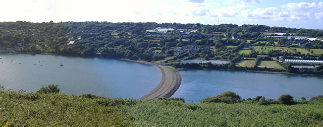
Le site concerné par le présent listing concerne
un cordon littoral appelé localement : Sillon
Cette remarquable flèche à pointe libre,
longue de 370 mètres, barre presque totalement l'intérieur de
l'anse de l'Auberlac'h. Sa formation a probablement débuté il y a
3600 ans, après la dernière glaciation, lors de la remontée du
niveau marin du à la fonte de la calotte glaciaire. Sa croissance
s'est faite progressivement par son extrémité, jusqu'à ce qu'elle
soit bloquée par les bancs très résistants des grès de Landévennec.
En arrière de ce poulier intérieur, une autre accumulation plus
courte s'amorce à partir de la rive sud engendrant un chenal
sinueux dans la passe maintenue ouverte par les violents courants
de marée (montante le "flot" et descendante le "jusant").
The site concerned with
this listing relates to an offshore bar called locally : Furrow
(Sillon)
This remarkable arrow with free, long point, 370 meters almost
completely bars the interior of "l'anse de l'Auberlac'h". Its
formation probably began 3600 years ago, after the last glaciation,
at the time of the increase of the marine level of to the cast iron
of the icecap. Its growth was done gradually by its end, until it
is blocked by the very resistant benches of the sandstones of
Landévennec. Behind of this interior "poulier", another shorter
accumulation starts starting from southern bank generating a
sinuous channel in the master key maintained opened by the current
violent ones of tide (rising the “flot” and downward
“jusant”).
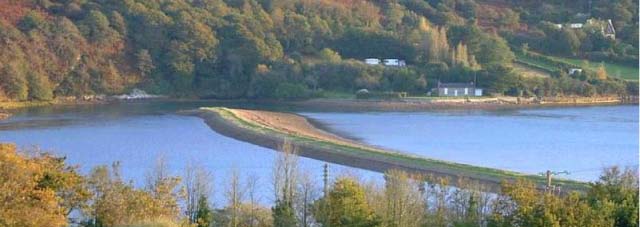
Pour valider votre découverte vous devrez
joindre à votre log une photo de vous ou de votre GPS prise à la
pointe de cette curiosité de la nature et m'indiquer, par
mail, la largeur approximative de la passe et ce que masque
le rectangle rouge de la photographie N° 4.
To validate your
discovery you will have to join to your log a photograph you or of
your GPS taken with the point of this curiosity of nature and to
indicate to me, by email, the approximate width of the master key
and what mask the red rectangle of photography N° 4.
Rappel concernant les «
Earthcaches »: Il n'y a pas de conteneur à rechercher ni de logbook
à renseigner. Il suffit de se rendre sur les lieux et d'exécuter
les requêtes du geocacheur (par exemple l'envoi d'un mail pour
validation)
| I am a proud |
 |