Rocky
Mountain (RM) Off Road Series (ORS) #10: Holy
Cross
A series by
Team
Red Rubicon members: RocketMan,
zoltig,
taylorsgeotracker,
Red
Ruby, Mountain
Roamer, and jpit
This cache is the second of seven in the
#10 series of Rocky Mountain off-road caches located along the
challenging Holy Cross Trail. The Holy Cross Trail starts out
from Homestake Reservoir Road off of US 24 about half way between
I70 and Leadville. This trail is definitely very challenging
to extreme and should only be attempted if you have the right
vehicle and lots of experience. This trail can easily be done
on foot also, so if your vehicle is not equipped, you can still do
the series (see full trail description below for driving and hiking
information).
Cache
Information
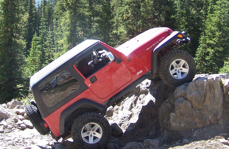
This cache is located next to
the second big obstacle called Steep Rock. There are
two primary approaches to this obstacle, a very steep one on the
left (pictured above) another steep one to the right of it. A
good spotter is critical on this obstacle, particularly with the
left approach because if you slip off the left side, the vehicle
would be sure to roll. If you don't have front and rear
lockers, you may not be able to make this obstacle without a winch
or tow strap assist, particularly if it is wet.
The cache is located above the
obstacle.
Cache Mileages
Driving from Start of Trail: 2.6 Miles
Hiking from the Return Trail Intersection: 1.3 Miles
RM Off Road Series #10
Compete Cache Listing
1.
The Notch
2.
Steep Rock
3.
French Creek Crossing
4.
Tippy Tree
5.
Holy Cross City
6.
Cleveland Rock
7.
Got
O2
Trail
Information
Rating/Description
Holy Cross trail is one of the most challenging hard-core trails
in
Colorado
. It is also one of the most popular premier trails in the
state. The trail has non-stop challenges and awesome scenery
all along the way. You will start out down in the valley
along the Homestake Creek and end up at almost 12,000 feet near the
tree line. Most of the trail is surrounded by the Holy Cross
Wilderness area.
This trail is rated difficult and make no mistake about it, it is
very difficult.
It is rated a 7 (easiest routes) to 9 (most
difficult routes) out of 10 on the traildamage
website.
With the current
condition of the French Creek Crossing, the trail should have a
minimum rating of 8 now. According to the sign at the trail
entrance, you will need a minimum of
the following equipment to do this trail:
Winch
Minimum 33 inch Tires
Front and Rear Lockers
Tow Straps
High Jack Lift
Disclaimer: You need to decide for yourself if
it is safe to make the trip in your vehicle and if you have any
doubts, don't do it.
The trail has the following named
obstacles (most of the caches in this series are at the
obstacles):
The Notch
The Slab
French Creek (Extreme - Body damage likely)
Tippy Tree (Rollovers possible)
Cleveland Rock (Extreme - Body damage and Rollovers
likely)
Most people, will drive up to Cleveland
Rock and stop there as that obstacle is difficult for even extreme
rock buggies. The only Team Red Rubicon member that tried it
was jpit and he got part way up but he may have rolled if he had
continued. The last cache "Got O2" is only a short
hike from Cleveland Rock.
Although from the start of the tail to
the end is only about 4 miles, plan to spend a whole day on the
tail. Team Red Rubicon got on the trail at 9:30 am and didn't
finish until almost 8:00 pm. We did spend extra time for
lunch, exploring and placing caches. You should get an early
start and expect the trial to take longer on a weekend where there
probably will be other vehicles that you will have to wait for at
each obstacle. Things can really stack up at French
Creek. It's not a bad idea to do the tail on a weekday if you
can swing it.
To get to the trailhead, take the
Homestake road exit from US 24 at N39 28.453 W106 21.719.
After traveling approximately 7.3 miles on Homestake road, you will
reach the Holy Cross trailhead at N39 24.178 W106 26.605. The
first part of the trail is one way. At approximately 1.3
miles, you will reach an intersection at N39 24.600 W106 27.326
with the return trail on your left. You will take the return
trail on the way back to avoid going the wrong way on the one way
section. If you drive up to the return trail intersection and
are not comfortable with the section of trail you have done so far,
don't go on as the trail gets much more difficult. You can
park on the return trail near the intersection and hike up, or just
go out on the return trail from this point.
After passing the return trail,
navigation is easy as there is only one way to go until you get up
to Holy Cross City at N39 24.921 W106 28.747. From the Holy
Cross City parking area, head west to the trail intersection at N39
24.894 W106 28.799 and then go right to get to Cleveland Rock at
N39 24.978 W106 28.866.
Return the way you came in until you get back to the return trail
at N39 24.600 W106 27.326. Take a right here and follow the
trail back to Homestake road at N39 23.893 W106 26.632. Stay
to the left and keep heading downhill to Homestake
Road.
Note: All coordinates in
the above description are included on the waypoint list
below.
Hiking
Information
You could hike the whole trail from the main trailhead at N39
24.178 W106 26.605 but it would be a 4.3 mile hike one way assuming
you stay on the trail. But, if you are planning on hiking,
you can drive up the return trail to the point where it meets the
main tail. The return trail is two way and can be driven in
almost any high clearance vehicle as the trail is easy. From
the point where the return trail meets the main trail, it is
approximately a 3 mile one way hike. The approximate hiking
distances are shown on each cache page in the
series.
Winter
Months
This trail is generally accessible to off road vehicles from late
June though late September or early October although conditions can
vary greatly from year to year. You should call the Holy
Cross Ranger District to ask about trail conditions.
Time/Distance
As mentioned in the trail description, plan a whole day. The
trail will probably take at least 7 or 8 hours and could take much
longer if you have vehicle damage or if there are many others on
the trail. The bottom line is get there early and don't plan
on being done until late in the day. To reach the trailhead
from the Denver area takes about 2.5 to 3 hours so leave the house
early.
Trail
Waypoints
See the first cache in the series
RM ORS #10: The Notch for trail waypoints.