This cache is a micro that's located off of Osburne Road at the
North Access to the Lake. This is a gated access so you must park
at the end and walk in. Be careful to stay in the driveway since
there is private property along both sides. When you get in to the
boat launch area you will see that it’s no longer usable
since there’s 300 yards of marsh before you get to open
water. Don't forget to write down the code for the coordinates to
the final of the series.
GC284JR
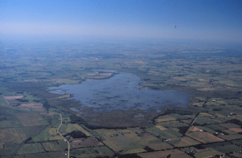
Rush Lake is a 3,000+ acre prairie pothole marsh bounded by two
low hills in southwestern Winnebago County, Wisconsin. Its size
makes it the largest prairie pothole east of the Mississippi River.
Historically, Rush Lake had extensive stands of native aquatic
vegetation and was home to a multitude of wetland birds, including
several threatened and endangered species. Some of the rare birds
that nest on the Lake include Wisconsin’s largest nesting
population of red-necked grebes, as well as Forster’s terns,
and black-crowned night herons. The emergent vegetation community
is dominated by cattails and hardstem bulrush, for which Rush Lake
was named. Average water depth of Rush Lake is 1.5 feet and water
levels are affected by a small dam located in the northeast corner
at the lake’s outlet to Waukau Creek.
The past 30 years witnessed a dramatic decline in the
lake’s aquatic vegetation, water quality, and wildlife
populations. Research has attributed these declines to artificially
stable and high water levels, carp infestation, and
nutrient/sediment runoff.
In order to tackle these problems and formulate a Lake
restoration plan, a steering committee was formed in 1999 including
government representatives, citizens, and user groups. The
15-member committee conducted monthly meetings from 1999-2005 and
completed an extensive citizen involvement process. The group
developed a plan that addressed all the significant problems facing
the lake and had strong public support garnered through citizen
participation. This plan is now being implemented as part of a
holistic lake restoration project.
The Geocache Notification
Form has been submitted to the Oshkosh office of the Wisconsin DNR.
Geocaches placed on Wisconsin Department of Natural Resource
managed lands require permission by means of a notification form.
Please print out a paper copy of the notification form, fill in all
required information, then submit it to the land manager. The DNR
Notification form and land manager information can be obtained at:
http://www.wi-geocaching.com/hiding
*Congratulations to CodeJunkie on the FTF*