Localização
O rio Lima é um curso de água internacional que atravessa o Alto-Minho, no Norte de Portugal e que nasce a uma altitude de 975 m no monte Talariño, na província de Ourense, na Galiza, Espanha. No seu percurso galego de 41 quilómetros, o rio é muitas vezes designado por nomes locais, como Talariño, Freixo ou Mourenzo, apesar da designação oficial galega ser Limia; aí passa, entre outras povoações da província de Ourense, por Xinzo de Limia, à qual dá o nome
Entra em Portugal, próximo do Lindoso e passa por Ponte da Barca e Ponte de Lima, até desaguar no oceano Atlântico junto a Viana do Castelo, após percorrer um total de 135 quilómetros.
Pertencente à bacia hidrográfica do rio Lima e à região hidrográfica do Minho e Lima. No seu contorno a norte é formado pela linha divisória do Rio Minho até à Serra de Arga e desta até ao Oceano Atlântico pelas serras de Perre e Santa Luzia; ao sul pelas serras da Amarela, Nora e Faro
O estuário desenvolve-se num vale relativamente estreito, sendo dominado pelo regime de marés e caudais fluviais. Estes sofreram alterações significativas com a construção do aproveitamento hidroeléctrico do Lindoso que permitiu o controlo de cheias na bacia, apresentando também alterações nas condições de penetração da frente salina para o interior do estuário

Em geografia, um estuário é a boca no mar, um rio largo e profundo, e os intercâmbios com a água salgada e água doce devido às marés. A boca do estuário é formada por uma largura de braço funil se arregalaram. Normalmente, tem praias de ambos os lados, onde a remoção de água permite o crescimento de algumas espécies de plantas que suportam águas salinas. Em suma, é o relevo que é gerado quando a água doce se mistura com água salgada.
-Os Estuários são causados pela entrada de água do mar na maré alta, mantém o rio, enquanto na maré baixa, todas as águas começam a entrar em alta velocidade no mar ou oceano, o que contribui para limpar e aprofundar a sua canal, muitas vezes deixando, grandes áreas de pântano.
Simultaneidade e variabilidade temporal de agentes naturais e da diversidade das ações humanas produzem uma ampla gama de regimes de água do estuário, em uma extremidade os relacionados com a escassez de recursos de água doce e, por outro aquelas causadas por inundações de rios e tempestades na boca
Quando o fluxo de água doce do rio está baixo, a dinâmica do estuário é dominado pela ação das marés e é chamado de regime de baixo fluxo.
-O regime domínio fluvial (corresponde à presença de grandes avenidas), a dinâmica fluvial controla o fluxo de água e substâncias no estuário, a erosão do canal e os processos associados com a maré, salinidade e turbidez, eles estão subordinados para isso.
-Entre eles dois, há um sistema misto rio-corrente em que a dinâmica do estuário passa sem interrupção entre estes dois regimes é reconhecido.
Classificação morfológica
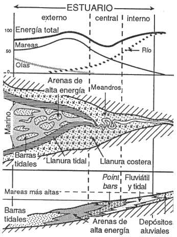
Existem dois tipos de estuários, dominadas pela energia das ondas, e dominado pelas marés.
a) Estuários dominados por ondas: nestes, as ondas têm um importante efeito na boca, onde o sedimento erodido do litoral é transportado ao longo da praia formando um bar. Isso restringe a boca, e irá formar até correntes de maré, que aumentam gradualmente com a secção transversal decrescente, para atingir o equilíbrio para que ponta da haste erosão de sedimentos é tão rápida como é a seu depósito de lá porque deriva litorânea
b) Dominada pela Márea: eles são formados como um resultado de correntes de maré importantes para o efeito das ondas. Boca geralmente tem bancos de areia são alinhados com a corrente de fluxo e em torno do qual circula o sedimento. Na cabeça do estuário a influência das marés e diminui o fluxo do rio se torna dominante.
Os dois tipos apresentados de estuários som duas extremidades, de que muitas variações podem ocorrer dependendo de fatores sedimentares ou morfológicas.
-Influencia mista de ondas e mareas.- Em um estuário dominado pelas ondas, se cresce a energia das marés, as crescidas da maré cortaram a barreira e a areia redistribuída construirá progressivamente barras de maré alongadas. Na parte central, o incremento da energia das correntes de maré cresce. Canais de maré são formadas, e as areias de origem marinha são depositadas. As margens do estuário são cobertas por depósitos de planície de maré. No fundo, o delta, anteriormente dominado pelo rio torna-se dominado pelas marés.
-Influencia das contribuições sedimentarias.- Se as contribuições sedimentares são importantes, o delta da boca progride e rapidamente enche o estuário. Da mesma forma o tamanho do corpo depende de os sedimentos marinhos do mar.
-Morfologia e tamanho do estuário.- Se o vale está enrolando, a areia frena as correntes de maré e diminui a sua energia, promovendo a formação pelas ondas de uma barreira. O gradiente costeiro (declive) e a amplitude das marés controlam o comprimento d os estuários. Além disso, o respetivo fluxo das marés e rio controlam o tamanho das áreas dominadas por tais processos.
- Recheio do estuário. - Em um estuário dominado pelas ondas, o crescimento do delta ao fundo da baía e do delta de maré enchem a parte central, onde o canal de maré e do canal fluviál se ligam, permitindo uma fácil entrada das correntes de maré.
Em um estuário dominado por correntes de maré, elas retrabalham ambas as areias: fluviais e do mar, que rapidamente preenchem as partes profundas e amplas, para formar a morfologia de funil. Em seguida, o sistema progride sem mudança significativa na forma. Em ambos os casos, se continua a crescer, o estuário é recoberto por um delta. A principal diferença entre estuário e delta é a direção de transporte do material: bi-modal no primeiro caso, para o mar no segundo.
Para registrar este earthcache, envie-me um correio eletrónico/mensagem com a resposta para as seguintes perguntas:
1) ¿Cal é o regime dominante no estuário?, Diga-me de uma característica deste tipo de estuários
2) ¿Cal é a principal diferença entre estuário e delta?
3) Segundo o panel presente no local, ¿Que tipo de rocas afloran nas praias que rodean o estuario?
4) Adicione uma fotografia sua no local ou outra na seja possível ver um objeto ou seu nick em um papel
- Se acredita ter concluído com sucesso os objetivos desta Earthcache e já me enviou todos os requisitos conforme solicitado, por favor, sinta-se à vontade para a registar como encontrada. Posteriormente verificarei os requisitos enviados e, caso seja necessário, contacta-lo no sentido de efetuar as devidas correções ao seu registo.
-Todos os logs sem respostas, serão apagados sem aviso prévio.
English (GoogleTranslate)
Location
The river Lima is an international watercourse that crosses the Alto Minho in northern Portugal and which rises to an altitude of 975 m in Talariño lot, in the province of Ourense in Galicia, Spain. In his Galician route of 41 kilometers, the river is often called by local names such as Talariño, Freixo or Mourenzo despite the Galician official name is Limia; there goes by, among other towns of the province of Ourense, for Xinzo de Limia, which gives the name
Come in Portugal, close to Lindoso and goes through Ponte da Barca and Ponte de Lima, to empty into the Atlantic Ocean near Viana do Castelo, after traveling a total of 135 kilometers.
Belonging to the basin of the River Lima and the river basin district of Minho and Lima. In its outline north is formed by the dividing line of the River Minho to the Serra de Arga and this to the Atlantic Ocean through the mountains of Perre and Santa Luzia; south by the mountains of Yellow, Nora and Faro
The estuary is developed in a relatively narrow valley and is dominated by the tidal regime and river flows. These have undergone significant changes with the construction of hydroelectric Lindoso that allowed the flood control basin, also showing changes in the saline front penetration conditions into the estuary
-In geography, an estuary is the mouth at the sea, a broad and deep river, and exchanges with the salt water and fresh water due to tides. The mouth of the estuary is formed by one arm width widened funnel. Usually it has beaches on both sides, where the removal of water allows the growth of some plant species that support saline waters. In short, it is the landform that is generated when the fresh water mixes with salt water.
-The Estuaries are caused by the entrance of seawater at high tide, retains the river, while at low tide, all the waters begin to enter at high speed in the sea or ocean, which contributes to clean and deepen their channel, often leaving, large areas of marsh.
Simultaneity and temporal variability of natural agents and the diversity of human actions produce a wide range of water regimes estuary at one end those related to the scarcity of fresh water resources and on the other those caused by river floods and storms in the mouth
When the freshwater flow of the river is low, the dynamics of the estuary is dominated by tidal action and is called low flow regime.
-In the "regime fluvial" domain (corresponds to the presence of large avenues), fluvial dynamics controls the flow of water and substances in the estuary, channel erosion and the processes associated with the tide, salinity and turbidity, they are subordinated to that.
Including two river-tidal mixed system in which the dynamics of the estuary passes without interruption between these two regimes is recognized.
Morphological classification
There are two types of estuaries, dominated by the energy of the waves, and dominated by the tides.
a) Estuaries dominated by waves: In these, the waves have an important effect in the mouth, where the sediment eroded from the coastline is transported along the beach forming a bar. This narrows the mouth, and will form until tidal currents, which gradually increase with decreasing cross section, to reach equilibrium so that erosion sediment rod tip is as rapid as is its deposit there because longshore drift
b) Dominated by the tidal estuaries: They are formed as a result of tidal currents important for the effect of waves. Mouth usually has sandbars are aligned with the flow stream and around which circulates the sediment. At the head of the estuary the tidal influence decreases and the river flow becomes dominant.
The two types are presented estuarine two ends, of which many variations may occur depending on sedimentary or morphological factors.
-Mixed influence of wave and tidal. - In estuarydominated by the waves, if growing tidal energy, tidal steps cut the barrier and the sand redistributed progressively build tidal elongated bars. In the central part, the income of tidal current energy grows. tidal channels are formed, and sands of marine origin are deposited. The banks of the lagoon are covered by deposits of tidal plain. In the background, the Delta, previously dominated by the river delta becomes dominated by the tides.
-Influence of sedimentary contributions.- If fluvial sedimentary contributions are important, the delta of prograde mouth and quickly filled the estuary. In the same way the size of the body depends on marine sediment from the sea.
-Morphology and size of the estuary.- If the valley is winding, the friction brakes tidal currents and lowers their energy, promoting the building by the waves of a barrier. The coastal gradient (slope) and the amplitude of the tides control the length of the estuarine system. Also the respective flow of the tides and river control the size of the areas dominated by such processes.
- Filling the estuary .- In an estuary dominated by the waves, the delta progradation bottom of the bay and the tidal delta fill the central part, where the tidal channel and the channel fluviátil bind, allowing easier entry of the currents tide. In an estuary dominated by tidal currents, they retrabajan fluviatiles both sands and sea, which quickly filled the deep parts and wide, to form the funnel morphology. Then the system prograde without significant change in shape. In both cases, if you follow the progradation, estuary filling is overlain by a delta. The main difference between estuary and delta is the transport direction of the material: bimodal in the first case, to the sea in the second.
To log this earthcache, send me an email with the answer to the following questions:
1) What is the dominant regime in the estuary ?, Tell me a characteristic of this type of estuaries
2) ¿What is the main difference between the estuary and delta?
3) According to the panel on site, ¿What kind of rocks usually interrupts the beach?
4) Add a photo of yourself at the place, or another in which you can see an object, or your nick on a piece of paper
-If you believe you have successfully completed this Earth Cache goals and has already sent to me all the requirements as requested, Please, feel free to log it as found. Later i will verify the requirements sent and, if necessary, contact you in order to make the necessary corrections to your log.
-Logs without answers, will be deleted without notice.
|
Sources:
-Introducción general sobre estuarios y mareas
-DISTRIBUIÇÃO SALINA NA EMBOCADURA E ESTUÁRIO DO RIO LIMA EM DIFERENTES REGIMES HIDRODINÂMICOS: Associação Portuguesa dos Recursos Hídricos
-Wikipedia |