Natural Monument Zamky EarthCache
-
Difficulty:
-

-
Terrain:
-

Size:  (not chosen)
Please note Use of geocaching.com services is subject to the terms and conditions
in our disclaimer.
[EN] Natural Monument
Zamky
[CZ] Prírodní památka Zámky
!!! ATTENTION !!!
During finding this earthcache you will wander very close to
cliffs. Be very careful, especially if you have children! Entering
at the cliff’s edges is not necessary.
!!! POZOR !!!
Behem nálezu této earthcache se budete pohybovat velmi blízko
útesu. Budte velmi opatní, obzvlášte budete-li mít s sebou deti!
Vstupovat na kraje útesu není nutné.
|
[EN]
Introduction
There are lots of interesting spots in Prague and this beautiful
piece of the nature certainly belongs to the one of them. Although
this earthcache is located outside of the main traffic you can
reach this place quite easy by foot or on bicycle. All the more you
can enjoy this relatively comfortable spot. Unfortunately not so
far from this is planned highway construction. But at these days if
you visit this earthcache you surely will not be disappointed
because the vista from the top of the rock is really cool.
Geomorphology
The natural monument Zamky is spread out on the eastern oriented
slopes of the river Vltava, between the estuary of Drahansky brook
and the settlement Zamky. The territory is divided to two parts by
sharply sliced Zamky’s gulch into. The territory is formed by
proterozoic rocks which are the oldest rocks in the Prague’s
territory. In a majority of the territory there rise to a surface
dark shale that settled at the bottom of ancient sea in more than
about 640 million years. In those shale later penetrated reefs of
diorite porphyrite and touchstone. Very these rocks together with
shale were mined as construction gravel in the big quarry in the
northern part. The aim of protection this area is preservation of
significant geomorphologic aggregation, preservation thermophilic
vegetable community of rocks and rock steppe which were kept on
poor soils and last but not least preservation of significant
archaeological locality.
Flora and fauna
In this locality there vegetate sets of rare and protected sorts of
vegetables. At steep rocks there vegetate rock madwort, on the edge
of rock slopes with shallow soils there vegetate rare Gagea lutea
(yellow star-of-Bethlehem), Veronica dillenii (Dillenius'
speedwell), Pulsatilla pratensis subsp. bohemica (small pasque
flower) and Anthericum liliago (St. Bernard's lily), on moderate
slopes with deeper soils vegetate community of grasses within
Festuca valesiaca (fescue grass), Erysimum crepidifolium
(wallflower), Vincetoxicum hirundinaria (swallowwort) and Cyanus
triumfettii (cornflower). In two places in southern part of the
locality, where basic minerals rise on the surface, there vegetate
rare community within Primula veris (cowslip), Sesleria caerulea
(blue moor grass) and Anthericum ramosum (Branching St. Bernard's
Lily). From significant and protected animals in the territory
there are occur mostly thermophilic insect representative – ground
beetles, leaf beetles, snout beetles. Furthermore there is possible
to see butterflies scarce swallowtail and sphinx. From vertebrates
you can see sand lizard, wood mouse and western hedgehog.
History
The history of settlement and usage this territory by men stretches
back as long as to era about five and half thousand years ago when
in Neolithic period originated highland settlement unit on a rock
promontory above the river Vltava. Later it was settled in
Chalcolithic (a.k.a. Eneolithic) period by people of Rivnac’s
culture and later then continually settled until Slavic people
coming. The grad (Slavic settlement) achieved the greatest
prosperity in the early period of Slavic settlement, in 6th – 8th
century A.D. From latter history is an interesting fact that in
Zamky’s gulch in 1870 was opened the first factory which produced
dynamite in Czech.
Other interests
Drahansky brook, which generate a northern border of natural
monument Zamky, springs at the northern periphery of Dolni Chabry.
A part of its stream generates a border between Prague and
Stredocesky (Middle Czech) region. It falls from the right into the
river Vltava northward from Bohnice. The place of an estuary of the
brook into the Vltava is the lowest place in Prague – 176 metres
above the sea level.
How to get the earthcache coordinates
The earthcache coordinates are reachable via several possible
pathways, namely by foot or by bicycle. First pathway for example
goes from the river Vltava upwards to the hill along the blue
tourist mark. Other pathway you can begin on the street U Drahane
where you also can park your geocar. In every case in certain point
you will have to turn off the blue touristic mark so that you will
reach the earthcache coordinates.
Approving the finding
To approve the finding of this Earthcache you need to:
1) Using profile e-mail me at what time period of proterozioc the
natural monument Zamky was formed.
2) On the access pathway to earthcache on coordinates N 50°08.724 E
014°24.319 is placed educational table that informs about natural
monument Zamky. Using profile e-mail in which natural monument
Zamky was announced (‘ROK VYHLASENI’) and its total area (‘CELKOVA
ROZLOHA’). Both items you can find out on the table.
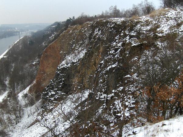
3) At the earthcache coordinates N 50°08.647 E 014°24.029 you can
(but it is not necessary) step forward towards cliff with
coordinates N 50°08.639 E 014°24.009. ATTENTION! Move very
carefully, below is a big steep hill! If you have children with
you, be very very careful! If you take a look at this cliff from
the View point at the coordinates N 50°08.685 E 014°24.042, you can
see that this cliff is formed by several explicit platforms
(terrain teeth). Count these platforms and using profile e-mail me
how many platforms have you counted.
4) At the earthcache coordinates N 50°08.647 E 014°24.029 using
your GPS module measure your altitude above sea level. Using
profile e-mail me:
a) your measured altitude above sea level and
b) height in which you are above the surface of the
river Vltava which you see under yourself.
5) Upload in the log a photo from the earthcache coordinates N
50°08.647 E 014°24.029 or from near cliff N 50°08.639 E 014°24.009
from which will be clear that you have visited the earthcache’s
place (see spoilers).
Please feel free to log your finding and to send your answers for
approving questions at the same time. If your answer will be
incorrect we will contact you for its correction.
[CZ]
Úvodem
V Praze je mnoho zajímavých míst a tento nádherný kousek prírody
urcite patrí mezi jedno z nich. Tato earthcache je sice umístena
mimo hlavní dopravní tahy, ale procházkou nebo na kole snadno
dostupná. O to víc si mužete nyní užít toto klidné místo. Bohužel
nedaleko odsud je plánována stavba dálnice. Dnes však pri návšteve
této earthcache urcite nebudete zklamáni, výhled z vrcholu skály
stojí za to.
Geomorfologie
Prírodní památka Zámky se rozkládá na východne orientovaných
svazích Vltavy mezi ústím Drahanského potoka a osadou Zámky. Území
je rozdeleno na dve cásti ostre zaríznutou Zámeckou roklí. Území je
tvoreno horninami proterozoika (starohory), které predstavují
nejstarší horniny na území Prahy. Ve vetší cásti území vystupují na
povrch tmavé bridlice, které se na dne tehdejšího more usadily v
dobe pred více než 640 miliony lety. Do techto bridlic pozdeji
pronikly žíly dioritového porfyritu a bazaltu. Práve tyto horniny
spolu s bridlicemi byly teženy jako stavební šterk ve velkém lomu v
severní cásti. Cílem ochrany území je zachování významného
geomorfologického seskupení, zachování teplomilných rostlinných
spolecenstev skal a skalních stepí, které se udržely na chudých
pudách a uchování významné archeologické lokality.
Flóra a fauna
V území roste rada vzácných a chránených druhu rostlin. Na strmých
skalách roste chránená tarice skalní, na hrane skalních svahu s
melkými pudami roste vzácný krivatec ceský, rozrazil ladní,
koniklec lucní ceský a belozárka liliovitá, na mírnejších svazích s
hlubšími pudami pak spolecenstvo trav s kostravou walliskou,
trýzelem škardolistým, tolitou lékarskou a chrpou chlumní. Na dvou
místech v jižní cásti území, kde na povrch vystupují zásadité
horniny, roste vzácné spolecenstvo s prvosenkou jarní, pechavou
vápnomilnou a belozárkou vetvitou. Z významných a chránených
živocichu se v území vyskytují prevážne teplomilní zástupci hmyzu -
strevlíkovitých, mandelinkovitých a nosatcovitých, dále je zde
možné zahlédnout z motýlu otakárka ovocného a lišaje pryšcového, z
obratlovcu pak ješterku obecnou, myšici krovinnou a ježka
západního.
Historie
Historie osídlení a využívání území clovekem sahá až do doby pred
asi peti a pul tisíci lety, kdy v mladší dobe kamenné vzniká na
skalnatém ostrohu nad Vltavou výšinné sídlište. To je pozdeji
osídleno v dobe eneolitu lidem rivnácské kultury a poté nepretržite
až do doby príchodu Slovanu. V dobe ranného osídlení Slovany, v 6.
- 8. století n.l., dosahuje hradište nejvetšího rozkvetu. Z novejší
historie je zajímavé, že v Zámecké rokli byla v roce 1870 otevrena
první továrna na dynamit v Cechách.
Další zajímavosti
Drahanský potok, který tvorí severní hranici prírodní památky
Zámky, pramení na severním okraji Dolních Chaber. Cást jeho toku
tvorí hranici Prahy a Stredoceského kraje. Do Vltavy se vlévá
zprava severne od Bohnic. Místo ústí potoka do Vltavy je nejnižším
místem Prahy – 176 m. n. m.
Jak se dostat na souradnice earthcache
Souradnice earthcache jsou dosažitelné více možnými cestami, a to
pešky nebo kolmo. Jedna napr. vede od Vltavy po modré turistické
znacce do kopce. Jiná cestu mužete zapocít v ulici U Drahane, kde
mužete zaparkovat své geovozidlo. V každém prípade budete muset v
jistém míste z modré znacky odbocit, abyste se k earthcache
dostali.
Uznání nálezu
Pro uznání nálezu této Earthcache je nutné:
1) Pres profil mi pošlete e-mail, ve kterém casovém období
proterozoika (starohor) se prírodní památka Zámky tvorila.
2) Na prístupové ceste k earthcache na souradnicích N 50°08.724 E
014°24.319 je umístena cedule informující o prírodní památce Zámky.
Pres profil mi pošlete e-mail, ve kterém bude uveden rok vyhlášení
prírodní památka Zámky a její celková rozloha. Oba údaje naleznete
na ceduli.
3) Ze souradnic earthcache N 50°08.647 E 014°24.029 mužete vykrocit
na útes se souradnicemi N 50°08.639 E 014°24.009. POZOR! Pohybujte
se velmi opatrne, pod vámi je velký sráz! Pokud máte s sebou malé
deti, dávejte na ne náležitý pozor! Podíváte-li se na tento útes z
Pozorovacího bodu na souradnicích N 50°08.685 E 014°24.042,
uvidíte, že je tvoren nekolika výraznými terasami (terénní zuby).
Tyto terasy spocítejte a pres profil mi pošlete e-mail, kolik jste
techto teras napocítali.
4) Na souradnicích earthcache N 50°08.647 E 014°24.029 zamerte
pomocí GPS nadmorskou výšku. Pres profil mi pošlete e-mail
a) s Vámi namerenou nadmorskou výškou a
b) s výškou v jaké se nacházíte nad úrovní hladiny
reky Vltavy, kterou vidíte pod Vámi.
5) Do logu priložte (upload) fotografii ze souradnic earthcache N
50°08.647 E 014°24.029 nebo z blízkého útesu N 50°08.639 E
014°24.009, ze které bude jasné, že jste místo earthcache
navštívili (viz spoilery).
Zalogujte Váš nález soucasne s posláním svých odpovedí na otázky
pro uznání nálezu. Pokud budou Vaše odpovedi nesprávné, budu Vás
kontaktovat pro jejich opravu.
Additional Hints
(Decrypt)
[EN]
1) hfr gur yvfgvat naq vagrearg; Cebgrebmvbp unq guerr renf, juvpu bs gurz vf pbeerpg?
2) svaq gur rqhpngvbany gnoyr naq svaq bhg gur erdhverq vasbezngvba
3) ybbx sebz gur pbeerpg cynpr ng gur pyvss naq pbhag cyngsbezf
4) n) hfvat TCF zrnfher nygvghqr nobir frn yriry naq o) fhogenpg nygvghqr nobir frn yriry bs Iygnin evire sebz lbhe zrnfherq nygvghqr
5) gnxr n cubgb ng gur pnpur pbbeqvangrf (frr fcbvyref)
[CZ]
1) cbhmvw yvfgvat n vagrearg; Fgnebubel zryl gev boqbov, xgrer wr gb fceniar?
2) anwqv anhpabh prqhyv n mwvfgv cbgeroar hqnwr
3) cbqvirw fr mr fceniarub zvfgn an hgrf n fcbpvgrw grenfl
4) n) mzre anqzbefxbh ilfxh cbzbpv TCF n o) qbcbpvgrw ebmqvy zrmv anqzbefxbh ilfxbh uynqval erxl Iygnil
5) ilsbg fr an fbhenqavpvpu pnpur (ivm fcbvyrel)