>
ENG.: The creation of this gorge began relatively late in the Ice Age which started 1,8 Million years ago. In this area, the height of the Late Ice Age was 17,000 years ago. However, this gorge only began to be created 12,000 to 14,000 years ago when massive glacial meltings worked its way through the limestone. The now, Ödenbach worked and filed its way through the mountain to create this natural phenomenon.

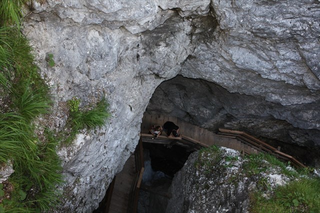
Still today it works itself through about 4 to 6mm rock per year. The gorge itself is 400m long and 80m deep. In some areas it is barely 80cm wide and opens up to 6m at the top.
This "Late Ice Age Gorge" was first made accessible in 1882 through the "Bayern's King's Forestry Commission" and was at that time named the "Kronprinz-Rudolf-Klamm". It was subsidized by moneys from the regional Austrian and German Alpine Clubs: Sections Pinzgau and Berchtesgaden and through "future visitors". In 1914 it was destroyed by storms and was not reopened until 12 years later in 1926 where it was then renamed the Vorderkaser-Klamm. 1940 brought about another huge storm which again destroyed all accessibility. This time it took 22 years before the town of St. Martin rebuilt and extended the gorge close to the form which we know now. In 1977 it was declared a protected natural monument in Land Salzburg.
The Vorderkaserklamm is declared by Land Salzburg as a: "400m long section of the Ödengraben between the Schnappenkogel and Ödenberg which runs into the Schüttbachgraben, the gorge is of a Hauptdolomit of the upper Triaszeit, a Limestone related oceanic sediment; about 200 million years old, contains petrified coralline algae, coral and remains of sea lilies; cleaves up to 80m deep; one of the most impressive gorges in Salzburg; Europe has very few such counterparts" (Land Salzburg Naturdenkmal 00149, Vorderkaserklamm)
 "
"
51 wooden footbridges with 35 stairs and 373 steps lead visitors through the sometimes very wet and slippery gorge.
In order to log this cache:
1. A gorge is created through erosion. Define erosion.
What type of erosion created this gorge? vertical or lateral erosion? Please explain why.
Do you think that the glacial melt water had much force or little? Explain why.
Do you think that the "Hauptdolomit" rock would be considered a hard or soft rock? Explain why.
2. The details of the gorge from Land Salzburg mentions petrified corals, algae and sea lily remains.
How did they get there? Is there a connection with the rock "Hauptdolomit"? What could that be?
Pictures are the second best part of earth caches (optional) post your favorite picture of the gorge.
Answers can be sent to my profile.
Feel free to log, I will contact you if something is wrong with the answers.
I will only accept logs from people who were actually at the Klamm!
So please beware, it is not always accessible!!
DE: Die Vorderkaserklamm liegt zwischen St. Martin bei Lofer und Weißbach bei Lofer in den Loferersteinbergen im Land Salzburg.
Die Eiszeit begann vor 1,8 millionen Jahren. Und obwohl der Höhepunkt der Späteiszeits in der Region vor 17.000 Jahren statt fand, began die Schaffung dieser Schlucht noch etwas später, und zwar vor 12.000 bis 14.000 Jahren gegen Ende der Späteiszeit. Die massive Schmelzwasserbewegung von der jetzt gennanten Ödenbach arbeitete und schliff seienen Weg durch den Kalkstein um dieses Naturwunder zu kreieren. Noch heute, arbeitet sich der Ödenbach jährlich durch 4 bis 6mm Kalkstein. Diese Eiszeitklamm war zuerst begehbar gemacht in 1882 durch die königlichen bayrische Forstverwaltung und wurde damals die "Kronprinz-Rudolf-Klamm" genannt. Und war "unter Besteuer der Umwohner der Sektion Pinzgau u. Berchtesgaden des D. und Ö. Alpenvereins und vielen späterer Besucher. " In 1914 wurde diese Arbeit durch einen Sturm ruiniert und erst 12 Jahre später in 1926 wieder resauriert. Die Klamm wurde neuernannt als die Vorderkaser-Klamm. 1940 kam wieder ein verherender Sturm. Diesesmal wurde der Zugang erst nach 22 Jahren wieder möglich, nachdem die Gemeinde St. Martin die Klamm übernahm und in 1963 wieder eröffnete und erweiterte in ähnlicher Form wie wir es jetzt kennen. Und so wurde auch sie in 1977 zum Naturdenkmal erklärt.
"400 m langer Abschnitt des zwischen Schnappenkogel und Ödenberg in den Schüttbachgraben mündenden Ödengrabens; die Klamm besteht aus einem Hauptdolomit der oberen Triaszeit;ein dem Kalk verwandtes Meeres-Sediment; Alter etwa 200 Jahrmillionen, enthält versteinerte Kalkalgen, Korallen, Reste von Seelilien; Klüfte bis zu 80 m Tiefe; eine der eindrucksvollsten Klammen Salzburgs; hat in Europa nur wenig Gegenstücke." (Beschreibung Land Salzburg Naturdenkmal 00149, Vorderkaserklamm)
51 Holzbrücken mit 35 Stiegen mit 373 Stufen führen den Besucher durch die manchmal sehr feuchte und rutschige Klamm.
Um den Cache zu loggen:
1.) Eine Klamm wird durch Erosion gemacht. Was ist erosion?
Welcher Art der Erosion hat diese Klamm geformt? linienhafte (linearer) oder flächenhafte Erosion? Bitte erklären.
Glauben Sie dass der Gletscherschmeltz viel oder wenig Kraft hatte? Weshalb?
Was glauben Sie, ist Hauptdolomit ein hartes oder weiches Gestein? Wie zeigt sich diese bei der Klammbildung.
2. Die Details gelisted vom Land Salzburg erwähnen "versteinerte Kalkalgen, Korallen, Reste von Seelilien". Wie sind sie dort hin gekommen?
Gibt es da eine Verbindung zum Hauptdolomit? Was könnte die Verbindung sein?
Bilder sind der zweitbeste Teil eines Earthcaches (freiwillig) poste euer Lieblingsbild von der Klamm.
Ich nehme nur Logs an von Personen die wirklich in der Klamm waren.
Bitte Warnung: Es nist nicht immer offen und zugänglich.
Bitte Antworten an mein Profile senden, online loggen und ich melde mich falls es ein Problem gibt.
All listing pictures are private, belonging to gabigirlhs.
All information was found on signs at the site or online on the websites: salzburg.com wiki, Land Salzburg and wikipedia.