The first time I visited Fredericksburg, my
not-yet-wife took me to the Falls of the Rappahannock to show me
this incredible spot where the wild mountain stream, full of
exposed bedrock and rapids turns into the wide calm river that
George Washington swam in as a boy. A couple of years later I
enjoyed returning to hunt the two caches on this island. I hope you
enjoy your visit to this beautiful spot and that you learn
something about this geological wonder, as well.
The questions and a
warning...
As a courtesy to my fellow cachers, I have
placed the questions you need to answer at the beginning of this
page, so that they do not get truncated by gps units that can only
display a limited amount of text in the description. Please take a
moment to read through the rest of the description to discover why
this place is so special, thank you.
In order to log this
earthcache you must answer these questions, and post your picture
to the cache page. You must also exercise caution, while this
location is safe, the water is not. Do not do anything that could
cause you to fall into the water, as there is a significant chance
of injury or drowning if you enter the water above the fall line.
When using your gps to record elevations, shoot them from the
beaches not the rocks. This is a beautiful spot, but like many of
nature's beauties it has it's own dangers and must be respected. I
should also mention that the island is connected to the shore by a
man-made structure that I have always used to access it. Now on to
the important stuff:
1. Proceed to the rock outcropping at the
posted coordinates and take a picture of your group to post to this
page. Here is an example of a picture of Scoot the Frog and
StShelby taken at these coordinates.

2. Walk to the upstream end of this island
and use your gps to record the elevation of the water
level.
3. While on the upstream end of the island
note the geological makeup of this island, what does this tell you
about it's creation and survival in this tumultuous area. What is
the main difference between the upstream and downstream ends of the
island.
4. Head back to the mainland and proceed
downstream to any point below the fall line, use your gps to record
the elevation of the water level. How far has the water dropped as
it crosses the fall line.
The Falls
The Rappahannock River
is a river in eastern Virginia in the United States, approximately
184 miles in length. It traverses the entire northern part of the
state, from the Blue Ridge Mountains in the west across the
Piedmont to Chesapeake Bay south of the Potomac. It is considered
by some to have been the boundary between the "North" and the
"South" during the Civil War, which are geographic regions still
referenced today. An important river in U.S. history, it was the
site of early settlements in the Virginia Colony and was later a
major theater of battle in the American Civil War. It drains an
area of 2,848 square miles, approximately 6% of the state of
Virginia.
The name of the river comes from an Algonquian language word
lappihanne (also noted as toppehannock), meaning "river of quick,
rising water" or "where the tide ebbs and flows." This name was
taken from the name given to it by the local native population the
Rappahannock Tribe.
The Rappahannock River begins as streams flowing from the eastern
slopes of the Blue Ridge mountains, flows southeast through the
fall line at Fredericksburg (where freshwater and tidal effects
meet), and ends as a wide estuarine river that meets the Chesapeake
Bay. The Rappahannock river is joined by the Rapidan river at a
confluence approximately ten miles northwest of Fredericksburg. The
Rappahannock River basin is 2,725 square miles in area, with a
maximum width of fifty miles in the headwaters, and a minimum width
of ten miles just north of Fredericksburg. There is also an
additional 2,432 miles of streams and rivers within the basin
providing an abundance of water resources.

The underlying strata of the eastern seaboard
along the Fall Line.
The Fall Line
The Fall Line is a low east-facing cliff
paralleling the Atlantic coastline from New Jersey to the
Carolinas. It separates hard Paleozoic metamorphic rocks of the
Appalachian Piedmont to the west from the softer, gently dipping
Mesozoic and Tertiary sedimentary rocks of the Coastal Plain. This
erosional scarp, the site of many waterfalls, hosted flume- and
water-wheel-powered industries in colonial times and thus helped
determine the location of such major cities as Philadelphia,
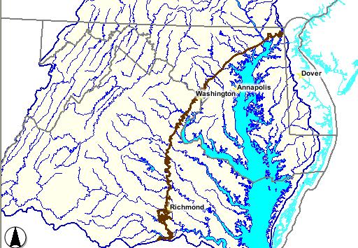
Baltimore, Washington, and Richmond.

The interstate highway is a rough guide to
the location of a geologic boundary known as the Fall Line, which
is the boundary separating the soft Coastal Plain from the hard
Piedmont. East of I-95, the soil is sandy, it is light-colored
(sometimes almost yellow or even white), and there are few hills.
West of the interstate, the plowed fields expose red clay and the
land rises steadily to the Blue Ridge, the eastern edge of the
Valley and Ridge. The Piedmont rock was once the soft sediments of
the Outer Continental Shelf, and located offshore from the ancient
shoreline of Virginia in the Iapetus Ocean. When Africa and Europe
bumped into the North American continent and created the
Appalachian Mountains, those soft sediments were scrunched up from
the ocean bottom and pushed onto the North American continent. In
the process of being scrunched, the sediments from the Iapetus
Ocean floor were squeezed and baked into the hard metamorphic rock
that now underlies much of Virginia between I-95 and the Blue
Ridge. The metamorphosed sediments are exposed at many spots along
the fall line including Great Falls on the Potomac River, just
upstream from Washington, DC and the Falls of the Rappahannock,
here in Fredericksburg.
After the continents collided and formed the
Appalachians, the continents then split and formed the Atlantic
Ocean. When it opened, the Virginia shoreline was at the eastern
edge of the Piedmont. Since then, sediments have washed down as the
mountains eroded. Those sediments have accumulated east of the
Piedmont to form the Coastal Plain. In addition, the water levels
in the Atlantic Ocean have risen at times, and deposited more
sediments east of the Piedmont to increase the extent of the
Coastal Plain. Those relatively recent Coastal Plain sediments,
formed by freshwater rivers eroding the modern Appalachian
Mountains and by deposition when ocean levels were higher, have not
been baked and squeezed tight like the Piedmont bedrock and are
much more subject to the effects of erosion.
When the Rappahannock flows eastward from
the Piedmont onto the Coastal Plain, it leaves a zone where the
riverbottom is hard rock and encounter easier-to-erode Coastal
Plain sediments. The energy of the water carves a deeper channel in
the softer sediments, creating waterfalls. This edge of the
Piedmont/Coastal Plain is marked by a line of waterfalls (the Fall
Line) where various rivers move from harder to softer
bedrock.

These photos show the effects of the Fall Line on
the navigability of the Rappahannock. These photos were taken
within 15 minutes of each other less than 1.5 miles
apart.
The waterfalls are most obvious at Great
Falls on the Potomac River, on the Rappahannock River at
Fredericksburg, and on the James River near downtown Richmond. The
waterfall on the Occoquan River near Lorton has been "dried out" by
the construction of a dam, trapping the water in the Occoquan
Reservoir, but you can see the exposed rocks at the Fall Line by
walking upstream from the town of Occoquan. The Fall Line is a zone
- sometimes several miles wide, rather than just a narrow line -
between the Coastal Plain and the Piedmont physiographic provinces.
The bedrock in the Piedmont is the hard crystalline rock that you
can see at this location and the sandy beach just below this spot
is evidence of the soil structure of the coastal plain that this
line marks the boundary of.
Email your answers to me and log the
cache.
I hope that you enjoy your visit to this
beautiful location, I visit every time I am nearby and I really
love it here. While reading an article about the fall line a couple
of weeks ago, I thought about how this island is a microcosm of
what is happening in the surrounding area, and how this would make
it the perfect classroom in which to learn about the Fall Line
while enjoying this wonder of nature. Have fun and be careful out
there.