
 This Earthcache looks at the formation of Southern
California’s second highest peak and the North America’s
second steepest terrain and a rain shadow.
This Earthcache looks at the formation of Southern
California’s second highest peak and the North America’s
second steepest terrain and a rain shadow.
 This location provides a wide
overlook of the San Gorgonio pass to the north and the
Coachella valley to the east, including, on clear days, the
Salton Sea. To the west and up another 2,000 feet or so is Mt.
San Jacinto. If you can make the hike, I would highly
recommend climbing the peak. I have read that you can see the
Channel Islands on clear days, but good luck finding a clear
day in Southern California.
This location provides a wide
overlook of the San Gorgonio pass to the north and the
Coachella valley to the east, including, on clear days, the
Salton Sea. To the west and up another 2,000 feet or so is Mt.
San Jacinto. If you can make the hike, I would highly
recommend climbing the peak. I have read that you can see the
Channel Islands on clear days, but good luck finding a clear
day in Southern California.
Mt. San Jacinto rises about 9,000 feet above the desert in less
than six miles. Only Telescope Peak in Death Valley has a steeper
topographic change in North America. The steep mountainside is the
result of both a sinking valley and a growing mountain.
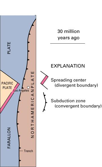
The creation of Mt. San Jacinto begins about 135 million years
ago, the end of the Jurassic. At that time the North American Plate
was moving over the Farallon Plate pushing the Farallon down into
the earth creating a subduction zone similar to plate margins of
the Pacific North West of today.
The melting Farallon plate created huge masses of molten magma
beneath the North American plate called plutons. These plutons
migrated up toward the surface. In some cases they erupted at the
surface as volcanoes.
About 70 million years ago, the late Cretaceous, most of the
Farallon plate had disappeared beneath the North American Plate
removing the source of magma for the region. The plutons cooled
into huge masses of granitic rock called a batholith (“deep rock”).
Mt. San Jacinto sits at the north end of the Peninsular Batholith
which extends hundreds of miles to the south. At this point, the
Peninsular Batholith was still deep underground.
Following the disappearance of the Farallon plate beneath the
North American Plate, the San Andreas Fault formed between the
Pacific Plate and the North American Plate. Movement along the San
Andreas moved the San Jacinto Mountains about 155 miles northwest.
Along the way, erosion continually removed rock above the
batholith.
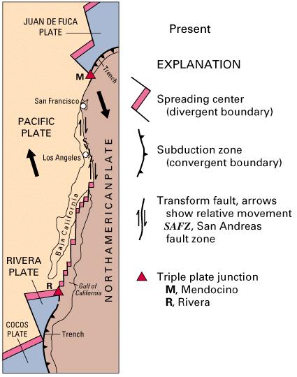 About 23 million years ago, the
Miocene, the spreading center that the North American Plate
moved over began to separate Baja California from North
America. This began a clockwise rotation of what would become
Baja California and began the uplift of the San Jacinto
Mountains. At the same time, the movement of Baja California
away from North America began forming a depression that
extends from the Gulf of California all the way up Imperial
Valley and Coachella Valley to San Gorgonio Pass. As spreading
deepened the valleys, the rising mountains filled in
depression. About 7.5 million years, the Gulf of California
formed and has been widening ever since.
About 23 million years ago, the
Miocene, the spreading center that the North American Plate
moved over began to separate Baja California from North
America. This began a clockwise rotation of what would become
Baja California and began the uplift of the San Jacinto
Mountains. At the same time, the movement of Baja California
away from North America began forming a depression that
extends from the Gulf of California all the way up Imperial
Valley and Coachella Valley to San Gorgonio Pass. As spreading
deepened the valleys, the rising mountains filled in
depression. About 7.5 million years, the Gulf of California
formed and has been widening ever since.
This configuration of a rising mountain and a deepening valley
continues today and has created the magnificent mountain you stand
on and the exceptionally steep mountain side in front of you.
Rain Shadow
This tall mountain range also forms a rain shadow creating the
large desert to the east that includes Palm Springs and the
Imperial Valley.
A rain shadow is formed when tall mountains force wet moist air
up. As the air moves up, it cools and looses its capacity to retain
moisture forming rain. As the air moves across the top of the
mountain it then descends back down where it warms and increases
its potential to retain moisture and less rain forms.
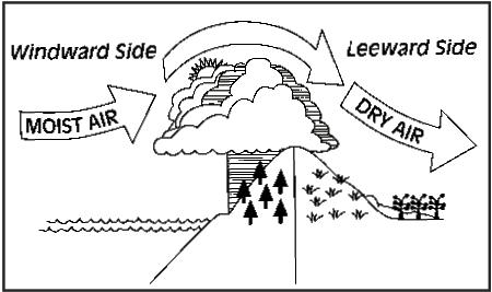 Here, moist air from the Pacific is blown on-shore where it is
forced up by the the mountain ranges all along Southern California.
At these higher elevations, the air cools and drops its moisture as
rain in the mountins. Once the air crosses the mountain ranges, the
air drops back down and warms. Now, not only has the air lost alot
of moisture by raining in the mountains, but it has also warmed and
can hold more moisture. Thus the landward side of the mountians
rarely gets water and a desert is formed.
Here, moist air from the Pacific is blown on-shore where it is
forced up by the the mountain ranges all along Southern California.
At these higher elevations, the air cools and drops its moisture as
rain in the mountins. Once the air crosses the mountain ranges, the
air drops back down and warms. Now, not only has the air lost alot
of moisture by raining in the mountains, but it has also warmed and
can hold more moisture. Thus the landward side of the mountians
rarely gets water and a desert is formed.
Logging requirements:
Send me a note with :
- The text "GCQHZT Mt. San Jacinto Earthcache" on the first
line
- The number of people in your group.
- Comparing the vegitation at the top of the mountain and the
vegitation down in the valley and the possible reasons for the
difference.
As always you can post any pictures of the area.
The following sources were used in generating
this cache:
- Images: USGS and NPS
- Paul Remeika and Lowell Lindsay. Geology of
Anza-Borrego: Edge of Creation. San Diego: Sunbelt Publications,
1992
- USGS,
http://pubs.usgs.gov/publications/text/Farallon.html
- San Jacinto DUSEL Detailed Site Information,
San Jacinto Dusel S2 Proposal, University of California Irvine,
April 20, 2005, http://www.ps.uci.edu/%7ESJNUSL/
- NPS,
http://www.nps.gov/grba/EdPages/RAG/Unit%204.pdf