
Falls of The Ohio River
_________________________________________
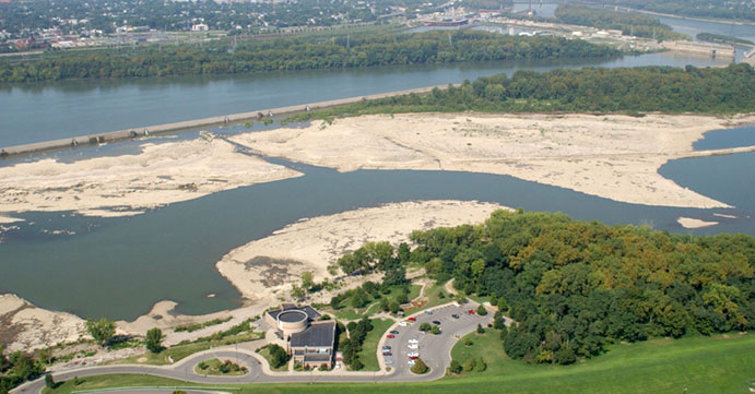 Present Day Falls Of The Ohio River
Best viewed from the Falls of The Ohio River Park located at Clarksville, Indiana. It is NOT necessary to stand at GZ to appreciate this site or log this cache!
This earthcache is located at the Falls of the Ohio River, the only navigational barrier along the 981-mile length of the river in earlier times.
The falls were a series of rapids, or CASCADES, formed by the relatively recent erosion of the Ohio River operating on 386 million-year-old Devonian period hard limestone rock shelves.
Louisville, Kentucky, and the associated Indiana communities of Jeffersonville, Clarksville, and New Albany all owe their existence as communities to the falls, as the navigational obstacles the falls presented meant that late 18th Century and early to late 19th Century river traffic could benefit from local expertise in navigating the 26-foot drop made by the river over a distance of two miles.
In its original form, the falls could be characterized more as rapids extending over a length of the river, than as a point-like discontinuity in a river such as Niagara Falls. Still, the falls provided a singular, dramatic and daunting obstacle to navigation on this important inland waterway.
The first locks on the river were built on a bypass canal there to provide year-round navigation on the river. The falls were then largely covered by the McAlpine Locks and Dam, built by the Army Corps of Engineers. The taming of the Ohio River at the falls, with the attendant reduction in local flow velocity has of late led to the covering over of the fossil beds by large and increasing quantities of low-velocity effluvia: although an impediment to viewing of the fossils, this action serves to protect the portions of the falls covered over by sediment and therefore temporarily immune to direct weathering. However, a significant area of the fossil-rich Devonian limestone rock is still left exposed, and is accessible to visitors today.
The best time for visitation is during the low water season of the Ohio River between August and October.
Removal of fossils is prohibited.
Because of the shallowness of the river at the Falls, it was a favorite crossing point for bison in pre-settlement times, and an easy crossing point for Native Americans.
In 1990, a section of the area in Indiana became the Falls of the Ohio State Park. An interpretive center is open throughout the year.
Geology
The rock unit upon which the falls are formed is referred to as the Jeffersonville Limestone. The limestone formed approximately 387 to 380 million years ago during the Emsian Age (in the latest part of the Early Devonian Period) and the Eifelian Age (Middle Devonian).
During the Devonian Period, the region lay at the bottom of a shallow inland sea about ten degrees north of the equator in the supercontinent of Euramerica.
To log this cache, do the following:
Take a picture of yourself and/or your GPSr with the Falls of the Ohio in the background.
To demonstrate the educational value of your visit please answer the following two questions:
1. Over what distance does the river drop at the falls and by how many feet?
2. The rock that the falls formed upon is referred to as what?
____________________________________________________________
Please email your answers to :
Please do not wait on a reply from me. FOUND IT logs which do not meet requirements will be quietly removed.