
Geologie Ripu/Geology of Mountain Rip
Czech :
Tato EarthCache se nachází na Památné hore Ríp, která patrí mezi Evropsky významné lokality a je státní kulturní památkou.
Tato EarthCache Vás seznámí s geologií hory Ríp. Souradnice N 50°23,464 E 14°17,433 Vás privedou k informacní tabuli na úpatí hory, kde si mužete precíst první informace o geologii hory. Zde se také seznámíte s první tabulí Naucné stezky - Ríp, která má svá stanovište na hore Ríp. Ke splnení úkolu této EarthCache Vás bude zajímat zejména tabule na samotném vrcholu, která je venována speciálne geologii hory Ríp.
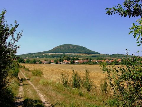
Hora Ríp dosahuje 459 metru nadmorské výšky. Vystupuje jako sopouch z roudnické roviny a je klasickým príkladem vyvrelé stolové hory, vzniklé v dobe tretihorní. Teleso Rípu lze považovat za bývalý hluboce erodovaný rozsáhlý vulkán. Predpokládané povrchové vulkanické produkty byly erozí zcela odneseny. Klasický zvonovitý tvar hory vznikl až pozdeji, uložením sute na úpatí hory. Složením je hora Ríp dosti výjimecná. Liší se od vetšiny ostatních tretihorních produktu vulkanické cinnosti v oblasti Ceského masivu. Podobné horninové typy jsou známy pouze ze stredoceské oblasti, jako je napríklad Slánská a Vinarická hora. Hornina Rípu má porfyrickou strukturu charakteristickou výskytem diopsidického pyroxenu, vzácne i olivínu v jemnozrnné základní hmote, tvorené prevážne nefelinem, rozloženým sklem, obou znacne premenených na analcim, a pseudomorfózami (vyplnenými novotvorenými minerály) sodalitové skupiny (sodalit, hauyn). Hora Ríp je známá silným magnetismem. Byla puvodne holou a bezlesou kupou, zalesnenou až v roce 1879, jejím tehdejším majitelem Moricem Lobkowitzem. V okolní krajine má velký význam jako prirozené útocište zvere a hnízdište ptactva. Na svazích se vyskytuje vzácná a teplomilná kvetena.
Pro uznání logu musíte splnit následující úkoly :
1) Součástí Vašeho logu musí být Vaše fotografie s GPS u tabule věnované geologii hory Říp, která se nachází na souřadnicích N 50°23,166 E 14°17,365
2) Na e-mail twicerap@volny.cz nebo přes náš profil zašlete odpovědi na tyto otázky :
a) Které dvě další známé oblasti (kopce) v Čechách jsou tvořeny podobným horninovým typem jako hora Říp?
b) Co způsobuje magnetismus hory Říp?
****************************

English :
This EarthCache is located on Mount memorable Rip, which belongs between important European locations. Rip is also an national cultural monument.
This EarthCache will familiarizes you with the geology Mountain Rip. The coordinates N 50°23,464 E 14°17,433 brings you to the information board on the bottom of the mountain, where you can read the first information about the geology of the mountain. There is also the first sign nature trails - Rip, which has its standpoints on the Mountain Rip. If you would like to be success in the tasks, for you is important the particular board on the top of the mountain, which is specially about geology of the Mountain Rip.
The high of the Mountain Rip is 459 m altitude. It is a classic example of eject table mountain, which was incurred during the Tertiary. The body of Rip can be regarded as a former deeply eroded large volcano. The supposed surface of the volcanic products has been fully carried away by the erosion. Classic bell-shaped form of the mountain was originated later, by depositing debris on the bottom of the mountain. The composition of Mountain Rip is quite exceptional. This mountain is different from the most of other products of Tertiary volcanic activity in the Bohemian Massif. The similar mineral types are known only from the Central area of the Czech Republic, for example such as the Slaný Mountain and the Vinarice Mountain. The mineral of Mountain Rip has got a porphyritic structure, which is characteristic by occurrence of diopsidic pyroxene, rarely quantity of olivine in fine-grained matrix, which is primary consisting by nepheline, glass divided, both substantially converted to analcim, and finally by the sodalits group of minerals. The Mountain Rip is known for the strong magnetism. It was originally bare mountain without forests, which has been afforested in the year 1879, by the owner Moric Lobkowitz. The Mountain Rip has got in the surrounding countryside the great importance as a natural place for the movement of animals and birds roost. On the slopes are occurred the rare and thermophilous flora.
For the recognition of the log must fulfill the following tasks:
1) As part of your log have to be your photos with GPS near the board of geology Mountains Rip, which is located at coordinates N 50°23,166 E 14°17,365
2) Through the GC.com profile or via e-mail twicerap@volny.cz send us the answers for these questions:
a) Which two other famous area in the Czech Republic are consist by the similar volcanic mineral as The Mountain Rip?
b) What does induce the magnetism of The Mountain Rip?
****************************
