Das Wiener Becken
Seit 20 Millionen Jahren senkt sich das Wiener Becken entlang von Bruchlinien um insgesamt 6 km ab. Dieser Vorgang ist nicht immer gleichmäßig, sondern geschieht manchmal ruckartig und in Begleitung von kleinen Erdbeben.
Gleichzeitig werden Sedimente abgelagert, so dass die entstandenen Senken wieder mit Gesteinsmaterialien verfüllt werden.
Der Harzbergbruch
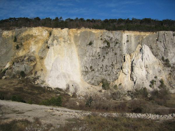
Hier verläuft in West-Ost-Richtung eine tektonische Bruchzone, das Merkensteiner Störungssystem. Der Steinbruch Bad Vöslau (ehemals Steinbruch Strauß) bietet einen Blick auf den größten österreichischen Aufschluss einer geologischen Bruchzone. Über eine Länge von 400 m und einer Höhe von 50 m liegt eine Fläche frei, entlang der es zu gewaltigen Verschiebungen in der Erdkruste gekommen ist.
Die im Zeitraum von 5 Millionen Jahren abgesenkte Tiefscholle befindet sich heute etwa 70 – 100 m tiefer als die Hochscholle (graue Kalke und Dolomite der Trias, 240 Millionen Jahre alt). Die auf der Tiefscholle abgelagerten Meeressedimente bilden die weiße Gainfarner Brekzie (16 Millionen Jahre alt). Diese wurde hier großräumig abgebaut und damit der Harzbergbruch (Neigungswinkel ca. 60 Grad nach Süden abfallend) freigelegt. Reste der Brekzie „kleben“ noch an der Felswand und bilden auch den Boden des Steinbruches.
Nur durch diesen Abbau ist es uns möglich, 2 Gesteine, die einen Altersunterschied von über 200 Millionen Jahren aufweisen, hier direkt nebeneinander zu sehen.
Logbedingungen
Schicke ein mail mit den Antworten zu folgenden Fragen über unser Profil:
Vor 16 Millionen Jahren bildete die Gegend von Bad Vöslau die Festlandküste eines tropischen Meeres. Vor der Küste gab es Inseln (ca. 30 km entfernt), die von Riffen umgeben waren.
a) Der Name des Meeres?
b) Heutiger Name der ehemaligen Inseln?
Der Harzbergbruch verläuft in West-Ost-Richtung.
c) In welchem Winkel verläuft er zu den Brüchen des Wiener Beckens?
Über ein Foto von dir/euch an den Headerkoordinaten, neben dem markanten Felsblock stehend, das GPSr sichtbar in der Hand haltend und mit dem Harzbergbruch als Hintergrund würden wir uns sehr freuen.
Der Bahnhof Bad Vöslau ist ca. 2,5 km (1,7 km Luftlinie) von Station 1 entfernt.
An den angegebenen Koordinaten (add. waypoints) sind ausreichend kostenlose Parkplätze vorhanden.
Station 1 und Station 2 befinden sich in unmittelbarer Nähe des Parkplatzes. Folge anschließend dem „GeoLehrpfad“ (grüne Schilder) bis du zum Harzbergbruch und zur Station 10 (dein Foto) kommst. (Die Stationsnummern sind vom Lehrpfad übernommen.)
Falls du einige künstliche Höhlen besichtigen möchtest, so nimm eine Taschenlampe mit.
Additional waypoints:
Parkplatz: N 47 58.076 E 16 12.109
Station 1: N 47 58.089 E 16 12.139
Station 2: N 47 58.081 E 16 12.122
Harzbergbruch: N 47 58.094 E 16 11.476
Station 10 = dein Foto N 47 58.149 E 16 11.348
TheVIENNA BASIN
Since 20 million years the Vienna Basin is sinking down almost 6 km along fault lines. This does not happen steadily, but sometimes jerky and accompanied by earthquakes.
Contemporaneous sediments are filling up the depression .
The HARZBERG- Fault
A tectonic fault zone – the Merkenstein fault system - extends in W-E-direction. The quarry “Bad Vöslau” (former: Strauß quarry) offers a view to the largest exposure of a geological fault zone in Austria. For a length of 400 metres and a height of 50 metres you may see the steep fault surface demonstrates the mighty shiftings of the earth´s crust. The lower block, sinking for about 5 million years is today 70 – 100 metres lower than the higher one. The latter built up of grey limestones and dolomites of Triassic age, 240 million years old. The former one is built up by marine deposits of the white Gainfarn Breccia of Neogene age (16 million years old). The Gainfarn Breccia was extensively quarried in the past exposing the Harzberg Fault with an inclination angle of 60 degrees sloping towards south). Remnants of the breccia are still present on the rock face and on the bottom of the quarry. The quarry in its present condition allows to observe two different rocks with an age difference of more than 200 million years.
Conditions to log this cache:
Send an e-mail with the answers to the following 3 questions to:
cg2007gc@gmail.com
16 million years ago Bad Vöslau has been situated at the shore of a tropical sea. Offshore, in a distance of about 30 km, islands surrounded by reefs were located.
a) The name of the sea?
b) Todays names of the former islands?
The Harzberg Fault extending in W-E-direction.
c) What is the angle between the Harzberg Fault and the fault zones of the Vienna Basin?
We would be glad if you add a photo of you at the header co-ordinates, standing beside the prominent rock with the GPSr in your hand and the escarpment of the Harzberg Fault in the background.
The railway station of Bad Vöslau is in about 2.5 km distance (1.7 km air distance) of stage 1. On the given co-ordinates of the parking area are enough free parking places.
Stage 1 and stage 2 are directly beside the parking area. Follow the “GeoLehrPfad” (green sign-posts) till you reach the Harzberg Fault and stage 10 (photo-point). The numbers of the stages are identic with that ones of the information path.
If you want to visit some man-made caves take an electric torch with you.
Additional waypoints:
Parking area: N 47 58.076 E 16 12.109
Stage 1: N 47 58.089 E 16 12.139
Stage 2: N 47 58.081 E 16 12.122
Harzbergbruch: N 47 58.094 E 16 11.476
Stage 10 = your photo N 47 58.149 E 16 11.348