Deutsch
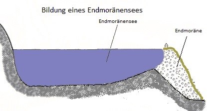
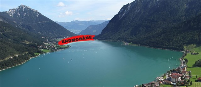
Der Achensee ist ein Endmoränensee , ein von Gletschern geschaffener Natursee
Entstanden ist der Achensee nach der letzten Eiszeit als mesozoisch gebildetes Quertal zwischen Karwendel- und Rofangebirge. Schuttströme der Seitenmoränen des Inntalgletschers, stauten das früher ins Inntal abfließende Wasser. Heute ist die Landschaft um den 6,8 km² großen und bis zu 133m tiefen See wegen ihrer Vielfalt Reizvoll: Liebliche Täler im Westen, die sanften Riesen des Rofangebirges im Osten machen den im Sommer karibisch türkisen See zum schönsten Tirols
 Der Inntalgletscher schürfte das Achenseetal vor rund (siehe Tafel ) Jahren aus ,
und es blieb Toteis zurück .Moränen des sich zurückziehenden Gletschers verriegelten das Tal weitestgehend
Endmoränen entstehen, wenn sich am Ende eines Gletschers Abschmelzen und Eisnachschub die Waage halten. Der Eisrand bleibt dann über längere Zeit stabil. Das Eis selbst bewegt sich aber nach wie vor.
Vom Inn-Gletscher ging die Vergletscherung der bayerischen und des östlichen Voralpenlandes aus.. Während die Voralpen bis auf die höheren Spitzen flächenhaft vergletschert waren, lassen sich mehrere Gletscherzungen identifizieren, die durch Haupttäler nach Norden vom Inntal abzweigten und die Vorlandgletscher bildeten.
-
über den Fernpass schob sich die westliche Zunge des Isar-Loisach-Gletschers, die über das Alpentor des heutigen Loisachtals bei Garmisch-Partenkirchen die Ammersee-Zunge bildete.
-
über den Seefelder Sattel rückte die östliche Zunge des Isar-Loisach-Gletschers vor, die sich im Raum Walchensee aufspaltete und über das Stammbecken des Kochelsees die Starnberger Zunge und die Wolfratshauser Zunge ausbildete, und über die Jachenau das obere Isartal und die Tölzer Zunge.
-
westlich des Rofan-Gebirges schob sich der Tegernsee-Gletscher nach Norden vor, schürfte den Achensee aus und schuf die Zungenbecken desTegernsees und des Schliersees. Ihre Schmelzwasser wuschen die Täler der Mangfall und der Schlierach aus.
 Volumen – Wasserinhalt: 481 Mio. m³
Umfang: 21,3km
Erdkrümmung: 1,38m
Theoretische Wassererneuerung: 1,9 Jahre
Wasserqualität: sehr gut
Fläche der gesamten Achensee Region: 390km²
( Quellen Wikipedia, Tafel Naturpark Karwendel )
Alle Hinweise können vor Ort gelöst werden
Logbedingungen :
1. Schätze wie breit das Tal bei Wegpunkt " 01 Endmoräne" ist , das von der Endmoräne verschlossen wurde.
2. Optional : Mach ein Foto von Dir und dem Achensee
3. bei der Tafel an den Headerkoortinaten : Wie alt ist das Karwendelgebirge ?
Vor wie vielen Jahren schürfte der Inntalgletscher den Achensee aus ?
Sende mir die Antworten über mein Profil
Es kann sofort geloggt werden, falls die Angaben stark abweichen melde ich mich.
Über Fotos würden wir uns sehr Freuen
Viel Spass wünscht euch hami+
English
The Achensee lake is a end moraines lake, a natural lake created by glaciers
The Achensee is emerged after the last ice age as Mesozoic formed transverse valley between the Karwendel and Rofangebirge. Debris flows of the lateral moraines of the Inn valley glacier dammed the water flowing formerly to the Inn valley.
Today, the landscape around the 6.8 km ² and up to 133m deep lake because of their diversity Beautifully: Lovely valleys to the west, the gentle giants of the Rofan in the east, make the turquoise lake in the summer to the most beautiful of Tyrol
The Inn valley glaciers scraped the Achensee Valley before round (see table) years,
and it remained stagnant ice back. Moraines of the retreating glacier locked the valley largely.
End moraines are formed when at the end of a glacier, melting and ice replenishment is balanced.
The edge of the ice is then stable over time. The ice itself but moves on.
From the Inn glacier went out the glaciation of the Bavarian and the eastern foothills of the Alps. While the Alps were glaciated areally up on the higher peaks, several glacier tongues can be identified that branched off through the main valleys to the north of the Inn Valley and the foothills glaciers formed.
-
over the Fern Pass be pushet the western tongue of the Isar-Loisach glacier, that formed the Ammersee-tongue over the saddle of the Loisachtal valley near Garmisch-Partenkirchen.
-
on the Seefeld saddle moved up the eastern tongue of the Isar-Loisach Glacier, which split in space Walchensee and trained on the root pool of Kochelsee, the Starnberg's tongue, and Wolfratshauser tongue, and on the Jachenau the upper Isar Valley and the Tolz tongue.
-
west of the Rofan Mountains, the Tegernsee glacier pushed northward, scraped out the Achensee and created the tongue basin least egern lake and the Schliersee. Their melting water washed out the valleys of the Mangfall and Schlierach.
Volume - water content: 481 million m³
Circumference: 21,3km
curvature of the earth: 1,38m
Theoretical water renewal: 1,9 Years
Water quality: very good
Area of the entire Achensee Region: 390km ²
( Quellen Wikipedia, Tafel Naturpark Karwendel )
All notes can be solved locally
Logging conditions:
1. guess how wide the valley at waypoint "01 Endmoräne ", that was closed by the terminal moraine.
2. Optional: Take a picture of you and the Achensee
3. panel by the Headerkoorinaten : How old are the Karwendelgebirge ?
How many years ago scraped the the Inn valley glacier the Achensee?
Send me the answers to my profile
It can be logged immediately if the details differ greatly I sign.
About photos we would be very features
Lots of fun wishes you hami +