River Mersey Bore EarthCache
-
Difficulty:
-

-
Terrain:
-

Size:  (other)
Related Web Page
Please note Use of geocaching.com services is subject to the terms and conditions
in our disclaimer.
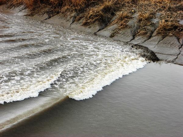
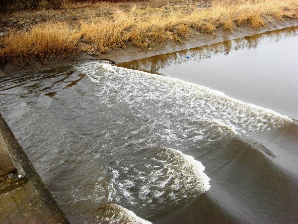
River Bores are caused when water flows up an estuary on a rising tide to produce a noticeable wave or ‘bore’. Worldwide there are only about 100 rivers that produce bores, of which about 20 are in the UK. They occur in funnel-shaped estuaries, and even then, decent sized bores only tend to occur in a handful of these rivers, and on a few days each year when there are the largest tides.
The UKs most famous and spectacular river bore is the Severn Bore, where it reaches up to 2 metres in height, and it is possible to kayak or surf the bore. In the North-West, the River Dee that passes through Chester and the Kent Estuary in Cumbria also have their own bores. Less well known, and more elusive, is the Mersey Bore that can be witnessed all the way from Hale Point and the Runcorn Bridge up to Howley Weir in Warrington. Occasionally this bore bounces back off Howley Weir, so it is sometimes possible to witness the wave a second time heading back down the Mersey.
To have the best chance of seeing the rare Mersey Bore it needs to be a Spring tide when the sun, earth and moon are aligned and combining to create the largest gravitational pulls on the seas, and thus making the highest tides - ideally 10+ metres. These tend to occur close to the Spring and Vernal Equinoxes (March & September respectively). Forecasts of tide heights and times of High Water (HW) in Liverpool can be found at http://www.ntslf.org/tides/tidepred
The times given below for each waypoint are relative to high water in Liverpool, but the bore, if it occurs (and it frequently doesn’t!), can be up to ten minutes before these times depending on local conditions. Tide times are normally listed in GMT, so during BST remember to add an hour. Always arrive early with your camera and be prepared, as the bore will not wait for you! As this is a wave, low lying land next to the River Mersey can get flooded, so take extra care in selecting a safe viewing location, especially with children and dogs.
To claim a find, please include the following in your log
1 - Co-ordinates and name of your chosen viewing location.
2 - The expected height and time of high tide in Liverpool.
3 - The actual time of the bore, and an estimated wave height.
4 - The speed of the bore in metres per second*
5 - Recent and current weather conditions e.g. wind direction/strength, is it during or after a wet or dry period?
6 – Optionally, photographs of the bore with your GPS and surrounding area in the picture.
* To calculate its speed, time how long it takes to cover a specific distance (eg between two points along the river bank). If possible, measure this distance with the GPS by waypointing one of these points, then walking to the other and seeing how far that point is away from the first (if this isn’t possible, just estimate the distance). For example, if the wave travelled 50m in 25 seconds, its speed is 50/25=2m/s. Everyone’s answers will be different as no two bores are the same!
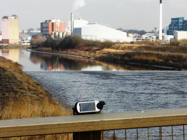
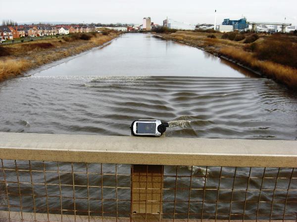
The listed co-ordinates are for the Forrest Way road bridge over the River Mersey. This is an excellent vantage point as it is elevated, and there are excellent views of the river in both directions. The other recommended viewpoints are in the vicinity of the Runcorn Bridge, and waypoints are given for them. The difficulty rating is purely based on the rarity of high spring tides of over 10 metres that produce a good sized bore on the Mersey.
On my first visit on 2nd March 2010.
1 - Forrest Way Bridge (N 53 22.763 W 002 37.042)
2 - HW Liverpool 12:09pm – height 10.19m (highest of year)
3 - Bore passed at 11:42am. Wave height estimated at 40cm
4 - Speed Estimated at approximately 3 m/s
5 - Today, calm, cool and sunny. Recently plenty rain!
On my Second visit on 3rd March 2010.
1 – Forrest Way Bridge (N 53 22.763 W 002 37.042)
2 - HW Liverpool (Gladstone Dock) 12:50pm – height 10.07m
3 - Bore passed at 12:28pm. Wave height estimated at 40cm
4 - Speed : 520m in 3mins 20 secs which is 2.5 m/s.
5 - Today, light SE Breeze, cool and overcast. Recently plenty rain!
Special thanks go to Tech17 for his assistance in providing valuable information about the Mersey Bore, used in the creation of this earthcache.
List of UK River Bore Earthcaches :
River Severn - GCN6EP - Severn Bore EarthCache (Gloucestershire)
River Dee - GCND09 - Dee Bore Earthcache (Cheshire/Flintshire)
River Kent - GC1400H - Kent Estuary Tidal Bore, Arnside Cumbria
River Trent - GC244QP - Trent Aegir - A Natural Phenomena
River Mersey - GC24HEP - River Mersey Bore
According to Wkipedia, the following United Kingdom rivers can also exhibit “Bores”. As yet, these are not listed as earthcaches
- Other tributaries of the Humber Estuary as well as the Trent
- River Parrett
- River Welland
- River Great Ouse
- River Ouse, Yorkshire
- River Eden
- River Esk
- River Nith
- River Lune, Lancashire
- River Ribble, Lancashire
Additional Hints
(No hints available.)