Now it lives on only in the name of two roads and a creek. This multi-cache will take you on a tour of the old village.
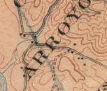
Start at N 37 22.875 W 122 23.495. Here, behind a gate and a rosemary bush you will find a vacant lot, surrounded by full grown Monterey cypress. This is the site of the Tunitas School, which stood on the watershed between Tunitas and Lobitos Creeks. It still shows on USGS topo maps. Back in the day, there were a few houses up here. Look around. Nearby you will see the same four numbers repeated three times. Those four numbers are ABCD.
Next proceed to N 37 22.985 W 122 24.000. The small creek you just crossed is Schoolhouse Creek, which combines just below here with Lobitos Creek to flow into the Pacific. The second cluster of homes that made up Lobitos was here. The old railroad station was along the creek on the other side of Hiway 1, now on private property. Look around. You should see four numbers nearby, all in yellow. They are EFGH.
Time for a little math. The final cache that you seek is at:
N 37 23.G(D+1)B W 122 24.A(E-5)(H+1)
You are looking for a 35mm film can.
As you drive Verde Road towards the final, you are following the former alignment of the old coast route, before it was straightened. Verde Road and the old stagecoach route head north towards another lost village, Purissima.
Update 2/23/07: Fixed a typo in the formula for the final. Apologies to any who tried to use the first one!