
Heligoland - is a small German archipelago in the North Sea
Geography
Heligoland is located 70 km (44 miles) from the German coast line and actually consists of two islands: the populated triangular-shaped 1 km² (0.4 sq mi) main island (Hauptinsel) to the west and the Düne ("dune," Heligolandic: de Halem) to the east. While the former is what the place name "Heligoland" normally is used to refer to, the latter is somewhat smaller (0.7 km²), lower, surrounded by sand beaches and not permanently inhabited.
The main island is commonly divided into the Unterland ("Lower Land," Heligolandic: deät Deelerlun) at sea level (to the right on the photograph, where the harbour is), the Oberland ("Upper Land," Heligolandic: deät Boperlun) consisting of the plateau visible in the photographs and the Mittelland ("Middle Land") between them on one side of the island; the latter came into being in the course of the "Big Bang" (see below).
The main island also features small beaches in the north and the south and drops down to the sea 50 metres (about 160 feet) in the north, west and southwest. In the latter, the ground continues to drop underwater to a depth of 56 metres below sea level. Northwest of the island proper Heligoland's famous landmark is found: The Lange Anna ("Long Anna" or "Tall Anna") which is a free standing new red sandstone rock (or column), weighing about 25,000 tonnes.
The two islands were connected until 1720, when the natural connection was destroyed by a storm flood. The highest point is on the main island, reaching 61 metres (about 200 feet) above sea level.
Although culturally closer to North Frisia in the German district of Nordfriesland, the two islands are part of the district of Pinneberg in the state of Schleswig-Holstein. The main island has a good harbour and is frequented mostly by sailing yachts.
Geology
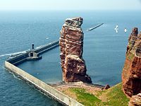
Lange Anna
The island of Heligoland is a geological oddity; the presence of the main island's characteristic red sedimentary rock in the middle of the German Bight is unusual. It is the only such formation of cliffs along the continental coast of the North Sea. The formation itself is from the early Eocene geologic age. It is younger than and layered on top of a much thicker bedrock of white chalk, the very same which is well known to form the white cliffs of Dover in England, and cliffs of Danish and German islands in the Baltic Sea. In fact, a small chalk rock close to Heligoland, called the whitte klippe (white cliff) is known to have existed within sight of the island to the west till the early 18th century, when storm floods finally eroded it to below sea level.
Heligoland's rock is significantly harder than the postglacial sediments and sands forming the islands and coastlines to the east of the island. This is why the core of the island, which a thousand years ago was still surrounded by a large, low-lying marshland and sand dunes and separated from coast in the east only by narrow channels, has remained to this day, although the onset of the North sea has long eroded away all of its surroundings. A small piece of Heligoland's sand dunes remains — the sand isle just across the harbour called Düne, which today holds Heligoland's airstrip.
Quelle: wikipedia
- How high ist the "Lange Anna"?
To log your visit send a photograph of your group (with GPS) at the site and email the answer to the above question.

Zum Cache:
Um disen Earthcache zu loggen müsst ihr nur eine einfache Frage beantwoten. Wie hoch ist die Lange Anna?
Schickt mir bitte Eure Antwort per Mail, danach könnt ihr sofort loggen.
Ein Foto könnt ihr dann Eurem Log anfügen, wenn ihr möchtet.
Happy hunting und viel Spaß auf der Insel wünscht
sanchopancho 