Geocaching - The Official Global GPS Cache Hunt Site

You are not logged in. Log in.


GC128K7

Traditional CacheThe Twelve Labors of Hercules: Labor Eleven

A cache by weeds19     Hidden: 4/15/2007

Size: Size: Regular (Regular)     Difficulty: 2 out of 5     Terrain: 5 out of 5 (1 is easiest, 5 is hardest)


You Are Not Logged InYou must be logged in with an account to view the detailed Location Information. It's free!

N/S ? ??.??? W/E ??? ??.??? 
In New Mexico, United States

Print:
 5 Logs 10 Logs | 

Download: Read About Waypoint Downloads

| | |

Warning

Please note: To use the services of geocaching.com, you must agree to the terms and conditions in our disclaimer.

This cache is a singular cache that can be done on its own or as part of a larger series of caches that make up "The Twelve Labors of Hercules"

Hercules is the Roman name for greatest hero in Greek mythology. Like most authentic heroes, Hercules had a god as one of his parents. Hercules was the son of the supreme deity Zeus and a mortal woman. As Hercules was growing up he was a victim of a number jealous attacks and antagonisms that eventually led him to kill his own children. To atone for his crime, he was sentenced to perform a series of tasks, or "Labors", for his cousin Eurystheus, the king of Tiryns and Mycenae.

Labor Eleven: the Apples of the Hesperides


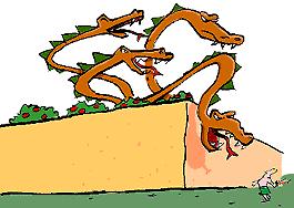
The Hesperides were nymphs entrusted by the goddess Hera with certain apples which she had received as a wedding present. These were kept in a grove surrounded by a high wall and guarded by Ladon, a many-headed dragon. The grove was located in the 
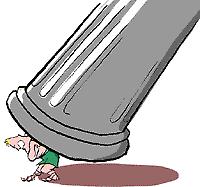
far-western mountains named for Atlas, one of the Titans or first generation of gods. Atlas had sided with one of his brothers in a war against Zeus. In punishment, he was compelled to support the weight of the heavens by means of a pillar on his shoulders. Heracles, in quest of the apples, had been told that he would never get the them without the aid of Atlas. The Titan was only too happy to oblige.


He told the hero to hold the pillar while he went to retrieve the fruit. But first Heracles had to kill the dragon by means of an arrow over the garden wall. Atlas soon returned with the apples but now realized how nice it was not to have to strain for eternity keeping heaven and earth apart. Heracles wondered if Atlas would mind taking back the pillar just long enough for him to fetch a cushion for his shoulder. The Titan obliged and Heracles strolled off, neglecting to return.

... and now onto the cache

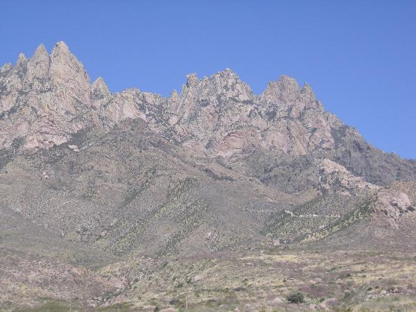
The cache is hidden at the top of Organ Needle. In the picture below the Needle is a part of the second from the right outcropping. It is the highest point in the Organ Mountains.


The climb to the top of Organ Needle is a full day affair and will require an elevation gain of ~4K feet. The climb will also require some rock scrambling and lots of hiking up steep, loose terrain. Bring plenty of water and energy for this one!

The most common method for ascending the Organ Needle starts at the road that leads up to Modoc Mine. Intrepid drivers with very capable vehicles can drive all the way to the mine, but for the rest of us the hike starts not far from Baylor Canyon Road. Here are some directions to get you to the correct road:
0.0 miles Exit I-25 at the University exit and drive east
4.9 miles continue straight at the junction with Soledad Canyon Road
6.1 miles cross a cattle guard
7.9 miles turn left onto Baylor Canyon Road
9.3 miles turn right onto a narrow dirt road heading east
9.6 miles bear right at a junction
Continue to follow this road (in vehicle or on foot) that gets increasingly rougher as it heads up the mountain.

Shown below is a view of the Organs from where a stock Grand Cherokee could comfortably drive to. In this photo you can see (bottom, middle right) the road cut just before it reaches the Modoc Mine.


The route to the top follows the old road past Modoc Mine (don't forget to grab the cache there!) and then a steep use trail that is cairned, but somewhat difficult to follow at times. Eventually the route heads up the length of Dark Canyon, a narrow, steep canyon that ascends to a small saddle alternately referred to as Dark 
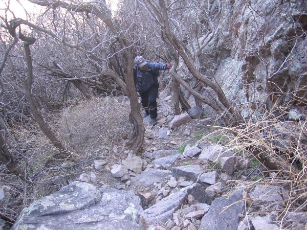
Canyon Saddle or Hummingbird Saddle. A typical segment of the trail in Dark Canyon is shown below as my climbing partner, Max, makes his way up.


From this saddle climbers should descend to the left and after a few feet this informative trail concrete marker will erase all doubt as to which way to continue.


Follow the instructions on the sign and after a few minutes you'll reach the crux of the route. A 20 foot high right leaning crack system that leads to easier ground above.


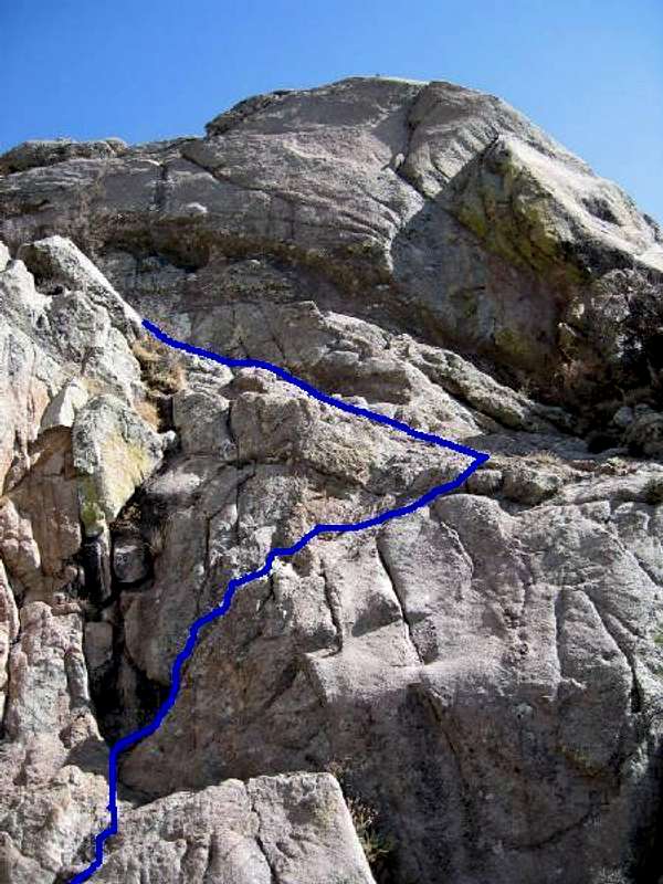
The route is a little intimidating at first glance, but upon further inspection good hand holds can be found. This section is certainly dangerous and unexperienced climbers should not attempt it if they feel uncomfortable. Remember, it's always easier to get up than it is to come down! Please use your best judgement. Some people do choose to use a rope on this section, because of that fact I am rating the terrain a 5. However, IMHO this section is a fair bit easier than the section on Florida Peak, but every climber is different.

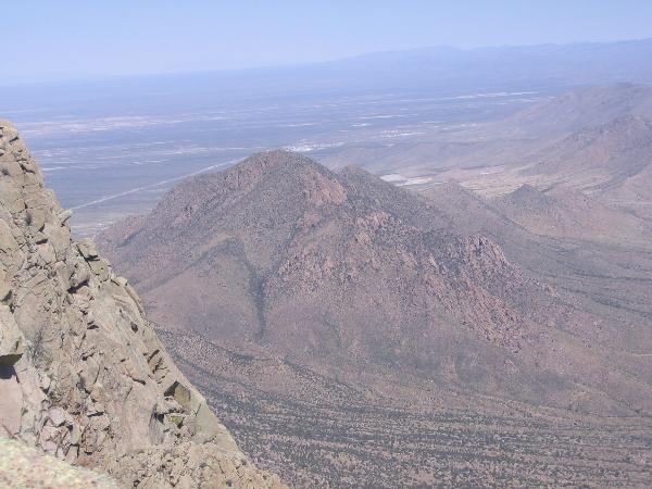
After breaching this barrier the summit is a short distance away and some spectacular views of the surrounding areas await. Shown below is that tiny little peak that constituted Labor 2, Baylor Peak!


This climb should not be undertaken with solely the knowledge gleaned from this page. Additional information about climbing Organ Needle can be found here:Gerry Roach's trip report, Adam Helman's trip report, and The Summitpost.org page

*** When you find the cache be sure to write down the three digit code inside the front cover of the log book. That code will be needed to find the final cache in the series. ***

Visit The Twelve Labors of Hercules: Labor Eleven details at the DGP


10 user(s) watching this cache.

Inventory Inventory

There are no Travel Bugs in this cache.
See the history
What is a Travel Bug?

Additional Hints (Decrypt)

Nybat gur obggbz bs gur furys(Decrypted Hints)

Decryption Key

A|B|C|D|E|F|G|H|I|J|K|L|M
-------------------------
N|O|P|Q|R|S|T|U|V|W|X|Y|Z

(letter above equals below, and vice versa)

Find...

Back lit Organs

Baylor Peak from Organ Needle

Concrete Instructions

Orchard

Pillar

The Organs

Typical trail on the way up Dark Canyon

Logged Visits (12 total. Visit the Gallery (41 images))

Found it9     Write note2     Publish Listing1     

Warning. Spoilers may be included in the descriptions or links.
Cache find counts are based on the last time the page generated.

 July 7, 2009 by Harried Harry (233 found)

On 5 Jul 09, Aberwak and I decided to labor up to find this cache. We left his house around 0545 and drove up Baylor Canyon to the turnoff. We then drove as far as we could (I don't know the miles, but it took an hour, lots of dings & scrapes on the truck, before we parked just below the cable across the road. We left the truck at 0730 and arrived at the top of the Needle just below the last challenge. I tried it twice, but almost fell. Aberwak tried it once and he almost fell. We then decided to try something different. He took off his small pack and left it with me; he was able to make it up the "last stretch" with a LOT of adrenaline.
Since it was only 1600, I decided I needed to eat my lunch. We had pushed pretty hard to get where we did. I am sorry to say, I didn't try that last little bit. I'll admit I was afraid I would get up the last bit, but not be able to get down. My knees and feet were really starting to tell me about all the pain I had given them on the way up. They didn't want to hear about climbing any more -especially since they knew what the terrain was like going back. I will admit the thought of slipping off the corner was not encouraging, especially since I used to be afraid of heights. It was nice sitting in the sun and watching the raindrops drop around me. At least it was cool.
Aberwak took about 20 minutes to find the cache and then took a lot of pictures. We will upload some pretty soon. The sight of the rain below us was great. He got some terrific shots of the sunset while we were in the saddle.
I am very grateful I had a very sturdy walking stick. Without it I would still be on the mountain. A good part of the way, I had to walk in reverse since my feet don't always do what I want them to do. The worst part of the trip was finding out my hiking boots have zero traction when the rock gets damp or wet (like at the waterfalls). What a waste of money. Now I know the only boots to wear are my old reliable work boots or running shoes. I'll get new boots soon that have some traction on slippery slopes so I don't have to worry about sliding down a couple hundred feet of rock face.
On Monday I was barely able to walk. I had to use my cane so I could stand up; without the cane, I would not have been able to get out of a chair. I think by Friday I'll be doing better. Now my biggest challenge is to climb the stairs at work (three flights) instead of taking the elevator. I know I need to do the climb, but my muscles sure tell me about it!
For those who are fit, like Aberwak, it is a GREAT challenge. I didn't know we had such beautiful canyons in this area. I encourage others to take the chance and do the trek. By the way, take plenty of water; I used 6.5 liters on my trip, although Aberwak only used two (darn youngster).

View This Log
 July 5, 2009 by Aberwak (799 found)

I think my dad and I can probably take the record for longest hike. We started out about 7:30 near Modoc (he was very determined to get his truck up as high/far as he could on that road). It started off a pleasant, slow-paced hike. The trail was very well marked for most of the way (plus, Mr. Waldo's waypoints helpd out quite a bit... but we still managed to lose the trail in a few spots) and quite enjoyable. At one point, or probably several, my dad fell- nothing major, but I'm sure not comforting to him. We thought we were doing good when we made it to Juniper Saddle still early in the day. The trail hadn't been too rough (for me, at least), and the weather was only slightly gloomy. Shortly after this, going through the next canyon was quite a pain- lots of bushwhacking, even though the trail was still oddly visible. It wasn't too bad- except for some nettles every now and then. We finally made to Dark Canyon Saddle. Oy. We weren't pleased with how the trail continued from there- it started going down, rather steeply, and around the peak. We wandered through there, wondering when to go up. We finally made it to the crux. *whew* It was already mid-afternoon. I tried to go up once, wasn't quite comfortable with it. Neither was my dad. I tried it without my backpack- felt much better. I managed to find some good handholds to feel I could do it. Once I was up, I took off to the Needle. My dad stayed behind, however. Getting to the Needle from the one steep part wasn't bad. It felt so great to be up on top of the Organs. I took quite a few pictures, but wanted to get back down (since I knew it'd take us a while). This didn't leave me with too much time to enjoy the view on top- just enough to walk around to the top, snap some pictures, and find the cache. Oddly, I don't think I ever came across that one sign indicating the Needle was 125 feet away. I was probably in too much of a hurry once I got up the crux- that I just went for the top.

Getting back down the crux was a bit intimidating, but also somewhat easier in some ways. It also helped that my dad was below me and could help me find holds. We made quite a bit better time going down than going up, despite my dad getting tired. He made it all in good health, with only a few minor falls, although he does claim he just barely made it back to the truck (8:30-9:00). Of course, by the time we did make it back there, it was already dark. I had actually taken a slight detour from the mine road to look for Modoc View. I ended up getting back to the truck just minutes after he got there.

Also on the way back, we experienced some pretty bad weather. After getting up to Dark Canyon Saddle, we noticed the dark clouds. We kept going, and by the time we came to the next clearing, we could see rain pouring over the valley. Very cool to look at, not so great considering how far of a hike we still had. The lightning added a bit of... "excitement?" into the way back. The rain also made some of the rock slippery. This made going back over the waterfall a bit intimidating. Luckily, by the time we made it back to Juniper Saddle, the bad weather had passed. We could see some sun out to the north of the valley, but rain elsewhere. As we made our way down from here, it remained dark. The sun came back out again for a while just before it set.

All in all, this was a great cache- I'm somewhat surprised I made it up to the top. I almost didn't think I was (especially just looking at the crux when I was beneath it). I managed to find the right handholds, and am glad I got up there. Glad I at least attempted it, wouldn't have been disappointed if I hadn't made it to the top- it's still a wonderful hike. This now completes my 11th Hercules cache. As always, the series is great- thanks for the effort.

[This entry was edited by Aberwak on Sunday, July 05, 2009 at 11:00:36 PM.]

View This Log

Photo Driving up
Photo The top of the Organ Mountains
Photo Aberwak at the top
Photo Top of the crux

 July 3, 2009 by dogue (491 found)

Well this one was a grueling 6 hour climb for me (don’t know how you hero's do it in 2.5-3 hours) from the Dripping Springs Visitors center to the peak. The day was slightly overcast and a little cooler than it had been and since I had to work this weekend it was the only day I could go, I decided to tackle this peak and LOH. The weather appeared a bit questionable but didn’t seem like it would turn to bad so I decided to forge ahead. The hike up was incredible, as Birddroppings stated, someone has cairned and flagged the trail pretty good together with that and the coordinates I got from Adam Helmans report I was able to pretty much stay on course, however there are sections that required some effort to locate the trail, nothing as difficult as the Sugarloaf trail but pretty close. The track log on my gps looks like a child did it using an etch-a-sketch though. The views were incredible, I'll only include a few of the over 200 pics that took. Once I entered Dark Canyon the effects of the recent rains become evident, the trail has become so overgrown that it resembles something you would see in Appalachians rather than here in New Mexico, I couldn't find the infamous, informative marker because of it. Once I reached the saddle of Dark Canyon I was surprised by the thick cloud layer pushing up out of the valley on the east side, visibility was reduced to 50' on that side. I located the CL3 climb and made the accent quickly to the peak. Once there, I found the cache and the summit log, signed both and marveled at the views. My plan was to eat lunch and let my legs recoup for a while before descending, but the mountain gods had other plans, thunder and lightning moved in with rain. I scurried down the CL3 and back to the Dark Canyon saddle where, huddled against the rock, I ate lunch and waited for the deluge to pass. Once a lull came I headed down through the now wet foliage were I became soaked through and through before another downpour began. I rested under a large pine tree and waited it out then began the down climb again, this time I made to the vicinity of the "On Slope" waypoint were a bolt of lightning flashed with no pause before the bang. I found cover under an overhang and waited out that deluge. The next leg I made it near the "Waterfall" waypoint when another 0 flash to bang lightning bolt made me seek shelter, this time I crawled under large flat rock and waited 30 minutes before the storm had moved on and the rain subsided. After that it was a leisurely hike back to the visitor’s center where (after a 4 hour descent) I arrived exhausted, soaking wet, covered in mud, battered and bruised from the spills I took on the way down. All in all a great hike and a lot of fun, however, this one marks the last of the LOH series I will be able to collect. I will be leaving for Germany next month then Afghanistan in December, I wish to thank Weeds for an outstanding series and the awesome memories I will take with me. I feel his caches will be the high water mark for any backcountry, mountain climbing, bushwhack caching adventures that other caches will be measured. T-bug repellant (the bugs were extremely annoying), L-army man as a battle buddy for the GI Joe, SL, TFTH.

View This Log
Photo The Goal
Photo Hummingbird nest
Photo Dark Canyon trail
Photo At Dark Canyon saddle
Photo Dark Canyon saddle
Photo Sugarloaf Peak
Photo Cache in hand
Photo Muggin on the peak
Photo Dripping Springs visitors center
Photo At the waterfall waypoint

 May 4, 2009 by Birddroppings (1985 found)

Back on Jan 4 of this year as Weeds and I bounced down the Modac mine road after climbing The Wedge I told him, and promised myself, that "This is the last time I'll ever drive up this road". I guess "Never say Never" applies here...cause I did it again today. And it does seem to get worse with each trip. I can't get my truck up as far as I used to be able to. In fact I think the road got worse in the 3+ hours I was parked up at the top. Because of the road, I was dreading this Labor. I shouldn't have...it ended up being a great morning!

I got off work last night at midnight. Got in bed and asleep around 1AM. Woke to the alarm at 4:15AM. Drove up from Santa Teresa and was parked just below the mine around 5:50AM. Plenty of daylight as sunrise was only 20 min away. But I was trying to beat the heat and I had to go to work in the afternoon so that prompted the early start. I huffed up the road and below the yellow outcropping. Immediately after getting off the road and on the trail I noticed that somebody has done some trail improvement in the form of clearing brush off of it, and tying florescent pink flagging along the way. It seems as though someone drove a heard of elephants up the mountain.

This was my 6th climb of the Needle and the easiest of them all. Because the route-finding is challenging in a few places, I always get off trail a time or two...but the trail was almost a no-brainer to follow today. Above Juniper Saddle up in Dark Canyon it's still a little brushy...but not as bad as I've seen it. The flagging makes it easy to get up and down the mountain. The summit register already had five names for May...a busy first weekend!

I got to the crux of the climb and walked up it without stopping as if were nothing. I guess 6 times up it will do that for you. I was at the top at 7:55AM...a 2hr and 5 min climb...my fastest. I think it's due to the easier trail following.

I was back down before 9:30AM so I easily beat the heat...and the rattle snakes (last time I almost got tagged by a Banded Rock Rattler).

This was another great Labor. I found out today...I love climbing the Needle more than I realized. It's views are incredible! The challenge of it's unrelenting steepness is a heart-pounder. Thanks for another great day in the hiking shoes. Ten down...two to go to get to the final.

SL

View This Log

Photo First Rays from above Juniper Saddle
Photo Early light shining through Dark Saddle
Photo Proceed as such...
Photo Cache in Hand
Photo Dark canyon immediately below
Photo Sugarloaf View from the Needle
Photo Looking down on the route's crux
Photo View off Juniper Saddle to the south

 March 1, 2009 by madmarauder (4 found)

Cache is still there. Showed to friends. No Log entries since my last visit. TNLN
-MMR

View This Log

There are more logs. View Them All on One Page

Current Time: 3/18/2010 7:54:48 PM Pacific Daylight Time (2:54 AM GMT)
Last Updated: 7/7/2009 8:30:03 PM Pacific Daylight Time (3:30 AM GMT)
Rendered: From Database
Coordinates are in the WGS84 datum


Geocaching, a Groundspeak Project.

Copyright © 2000-2010 Groundspeak, Inc. All Rights Reserved.
About Groundspeak | Contact Us | Knowledge Books
Designated trademarks and brands are the property of their respective owners.
Use of this Web site constitutes acceptance of the Groundspeak Terms of Use.
Read our Geocaching Logo Usage Guidelines.
Hotels | Altrec Gear | GPS Reviews