Moel yr Hydd – Moelwyn Mountains
Introduction
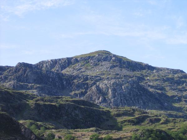
Moel yr Hydd (Hill of the Stag) lies at the heart of the Moelwyn mountains. My favourite approaches all start from the appropriately named village of Tanygrisiau (Bottom of the Steps), though you could start from Croesor instead. It is a small but rocky mountain, often used for mountain leader & climbing courses. Ironically, most of this wild and rugged area was excluded from the Snowdonia National Park when it was created.
Moel yr Hydd is also at the heart of an important slate quarrying area. Clockwise from the north are, Conclog, Cwmorthin, Wrysgan, Moelwyn, Croesor and Rhosydd Quarries. Wrysgan is the easiest of these to include in an ascent of Moel yr Hydd, with its incline through a tunnel being an obvious feature seen from the café at Llyn Tanygrisiau. The Rhosydd craters are a spectacular remnant of the slate industry between Moel yr Hydd and Moelwyn Mawr. Please be careful near these giant holes, especially the eastern one, which is still actively collapsing. The underground journey from Croesor to Rhosydd quarry is probably the most adventurous (& dangerous) approach to Moel yr Hydd available!
The south eastern face of Moel yr Hydd has been carved by the glaciers of the last ice age to reveal cliffs made of what is know as the Moelwynion Volcanic Formation (MVF for short). There are some great roche moutonee at the entrance to Cwmorthin. Over the millennia, the softer rock has been eroded from its igneous surroundings to leave lots of holes. These pockets make excellent hand holds for climbers and there are some classic routes on Craig yr Wrysgan and Clogwyn yr Oen (Cliff of the Lamb). My favourites are Gelynen, finishing with Honeysuckle Corner and Kirkus’s Climb Direct: beautiful on a summer’s evening.
At the foot of Moel yr Hydd is Llyn Tanygrisiau. This is the lower reservoir for a pump-storage power station, which uses more electricity than it makes. Find out why here… The Lakeside Café does meals, teas, ice-cream and homemade cake. Excellent for tired geocacher! You can also pay to drive up to Stwlan Dam here and start your walk up Moel yr Hydd from 500m above sea level, but that would be cheating!
Some Routes to the Top
All of these routes start from the car park above Tanygrisiau (SH 68290 45444). This list is by no-means exhaustive and the adventurous scrambler will be able to find many new routes and variations. On the evening that I placed the cache, I didn’t use any of these routes to go up or down! The OS maps have the area on the join between both 1:50,000 & 1:25,000 sheets and contain a lot of clutter. There is a Harvey’s map which covers the area with no joins. In the gallery there is a sketch map with my route numbers on that you can print out. I hope that it helps!
- Follow the track towards Cwmorthin and cross the river into a garden of trees. Follow the track out of the garden and around the end of a rocky ridge. Turn left and follow the miner’s steps and inclines up to Wrysgan Quarry and eventually to the tiny reservoir of Llyn y Wrysgan. From here you can either scramble directly up to the summit (following the electric fence in places) or follow a faint path around to the bwlch (col) between Moel yr Hydd and Moelwyn Mawr. From the bwlch, turn right and up easy, grassy slopes to the summit.
- Either walk up the dam road to where the incline crosses it or follow the climbers’ path to Craig yr Wrysgan. Work your way up to the mouth of the tunnel and scramble up it to emerge at Wrysgan Quarry. Continue as for route 1. You don’t normally need a torch for this route.
- Walk up the road to Stwlan dam. From the east end of the dam, follow a small path up to the bwlch between Moelwyn Mawr and Moel yr Hydd.
- Walk up the road, turning off at a footpath sign and crossing a stile. Go up to the dam and then scramble up the rocks at its base to its western end. Go up to Bwlch Stwlan. From here you can follow the miners’ path around the cwm to the bwlch between Moelwyn Mawr & Moel yr Hydd or ascend Moelwyn Mawr with its geocache (GCXYEV) by charlieg0pzo. Peak baggers can also pop up Moelwyn Bach from here!
- Go into Cwmorthin on either side of the river and then follow the track around Llyn Cwmorthin and up to Rhosydd Quarry. There is a geocache here (GCG7BF) by BESS’S FRIENDS. Follow the inclines up to the big holes at the bwlch between Moelwyn Mawr & Moel yr Hydd.
- My favourite! Go into Cwmorthin and along the lakeside track to around SH 67747 46194. Turn left and start scrambling along the top of the roche moutonee ridge. Cross a boggy patch and go up a gully on to the main ridge. At the top of the gully, turn left and keep scrambling along until you reach an electric fence. Follow this to the summit.
- The longest (that I’m listing!). Go up the track into Cwmorthin and keep following it around the east side of the lake until a right turn just before the old mine buildings. The track goes steeply but safely, up through the old spoil tips. When you run out of track, follow a path onto the ridge and then turn left along to the summit of Allt Fawr, with its geocache (GCX1ER) by charlieg0pzo. In places on this ridge, there are large “crevasses”, caused by 6,000,000 tons of rock collapsing into Cwmorthin mine in 1894. Descend to the outflow of Llyn Conclog and then navigate down to Llyn Cwm-corsiog. Take the path down to Rhossydd Quarry.
Books
J Meirionnydd – Climbers’ Guides to Wales – ISBN 0-901601-63-2 – Only of interest to rock climbers.
J Snowdonia Rocky Rambles – Bryan Lynas – ISBN 1-85058-469-9 – Guided geological walks for the non-specialist. Includes a route around (but not up!) Moel yr Hydd and walks that take in lots of other geocaches in Snowdonia.
J A Gazetteer of the Welsh Slate Industry – Alun John Richards – ISBN 0-86381-196-5 – Does what it says on the tin.
J Cwmorthin Slate Quarry – Graham Isherwood – ISBN 0-9522979-1-4 – An in depth study of the quarry with maps & photos, both old and new. Contains a fascinating interview from 1895 about working conditions.
J Rhosydd Slate Quarry – MJT Lewis & JH Denton – ISBN 0-9522979-0-6 – Similar to the above book.