Die Wingertsbergwand EarthCache
-
Difficulty:
-

-
Terrain:
-

Size:  (other)
Please note Use of geocaching.com services is subject to the terms and conditions
in our disclaimer.
Achtung!
Je nach Regen der vergangenen Tage kann man ggf. nicht mit dem Auto bis ganz zur Wand fahren.
Attention!
Depending on the rain during the last days it may not possible to go with the car close to the wall.
English version see below
Die Wingertsbergwand
Dieser EarthCache führt euch zur Wingertsbergwand.
Der Berg gehört zu den schönsten und bekanntesten Vulkanaufschlüssen der Eifel. Der Wingertsbergvulkan ist das Ausbruchszentrum der beiden Niedermendiger Basaltlavaströme. Er war ursprünglich 322 m hoch, er wurde inzwischen vollständig abgebaut.
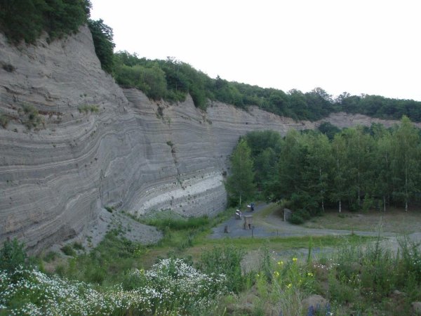
Die Wingertsbergwand ist eine bis zu 30 m hohe Wand nördlich des Wingertsberges. Man kann hier anhand mehrerer Tephrasequenzen den gewaltigen Ausbruch des Laacher See Vulkans auf einmalige Art rekonstruieren.
Die Tephraablagerungen am Wingertsberg sind typisch für sogenannte Plinianische Eruptionen - explosive Ausbrüche, die große Mengen vulkanischer Asche fördern. Bei den Gesteinen in der Wingertsbergwand handelt sich um Ablagerungen aus Glutlawinen und um die Produkte von vulkanischen Ascheregen. Die Tephra ist besonders im unteren Teil reich an großen Fremdgesteinseinschlüssen, insbesondere an Basalt aber auch an devonischem Grundgebirge.
Die Ablagerungen aus Glutlawinen sind unregelmäßig, faserig geschichtet und zeigen interne Strukturen, die auf einen raschen Transport hindeuten. Man beobachtet starke, rasch wechselnde Korngrößenunterschiede, mit einem allgemeinen Trend zu feineren Korngrößen in den jüngeren Ablagerungen. Die feinen Tufflagen in den höchsten Schichten stellen die noch Tage nach dem Ausbruch herabregnenden Aschepartikel dar.
Quellen: Schaubilder vor Ort & http://www.geomontanus.com/
Um diesen EarthCache zu loggen, mußt Du folgende Fragen beantworten (siehe Schautafeln!) und an eine bestimmte eMail Adresse senden:
- Frage1: Ausbruch fand vor wie vielen Jahren statt? (5-Stellige Zahl)
- Frage2: Eruptionsdauer (die größere 2-Stellige Zahl der Tagesabgabe; Monate ignorieren)
- Frage3: Eruptiertes SO2-Gas (die größere 2-Stellige Zahl)
Deine Antwort wird automatisch geprueft & und Du bekommst innerhalb weniger Minuten eine Antwort mit (oder ohne) Logerlaubnis. Solltest Du keine eMail innerhalb einer Stunde erhalten, schreibe zur Sicherheit mir eine Mail über mein Profil.
Weiterführende Informationen:
http://de.wikipedia.org/wiki/Laacher_See
Anfahrt:
Von der Laacher-See-Straße kommend die Laachgrabenstraße durchfahren und die Brücke überqueren. Dort dann links abbiegen und nach wenigen Metern den Feldweg recht nehmen. Dann der Beschilderung „Wingertsbergwand“ folgen. Ihr braucht keinen Offroad Wagen.
Wir wünschen euch einen interessanten Ausflug!
Martin & Julia aka WEINEMA
The Wingertsbergwand
This EarthCache leads you to the Wingertsbergwand (“Wingertsmountain wall”).
The mountain belongs to the most beautiful and most well-known volcanic explanations of the Eifel. The Wingertsbergvulkan (“Wingertsmountain volcano”) is the outbreak center of the two Niedermendiger basalt lava streams (Niedermendig is a part of the city Mendig). The mountain was originally 322 m high; it has since been completely diminished.
The Wingertsbergwand is to the north of the Wingertsberg one, a wall up to 30 m high. One can reconstruct on the basis several Tephrasequenzen that the enormous outbreak of the Laach lake volcano here is unique.
The Tephra deposits at the Wingertsberg is typical for so-called Pliniani eruptions - explosive outbreaks which promote large quantities of volcanic ash. With the rocks in the Wingertsbergwand concerns around deposits out of glow avalanches and the products of volcanic ashtray gene. The Tephra is particularly in the lower part richly at large foreign rock inclusions, in particular at basalt in addition, at devonischem basement.
The deposits from glow avalanches are irregularly and fibrously laminated, and show internal structures which point to a rapid transport. One observes strong, rapidly changing grain size differences, with a general trend to a finer grain size in the recent deposits. The fine sediments of Tuff in the highest layers represents still the days after the outbreak raining ash particle.
Sources: At site information & http://www.geomontanus.com/
In order to log this Earthcache as found, you must answer following questions (see information plates) and send an email to a specific email address:
- Question1: Outbreak took place before how many years (5 digit number)
- Question2: Eruption duration (the larger 2 digit number of the days specification; ignore the month)
- Question3: Erupted Pumice (=Bims) (the larger 2 digit number)
Your answers will be checked automatically and you will receive an automatic email with (or without) your log permission. If you don't receive a mail within one hour better send me an additional mail via my profile.
Further information:
http://de.wikipedia.org/wiki/Laacher_See (in german, but some links are available in english)
How to get there:
Coming from the Laacher-See-Strasse follow the Laachgrabenstrasse and cross the bridge. Then turn left and after few meters follow the dirty road on the right. Then follow the signs "Wingertsbergwand". You do not need a 4WD.
We wish you an interesting trip!
die WEINEMAs
Additional Hints
(No hints available.)