Every bench mark hunter and land surveyor should know about this
place. MEADES RANCH is the Geodetic Center of the nation,
the "Primary Station" for all surveys in the United States and in
Mexico and Canada. With permission from the owners, this event is
for all who wish to make the trek to the geodetic "Mecca" of the
surveying world - to the Meades Ranch bench mark.
The Meades Ranch bench mark is generally located 45 miles
northeast of Hays, Kansas, and 60 miles west-northwest of Salina,
Kansas. Coordinates displayed on this page are in degrees, minutes,
and decimal minutes, the format common to Geocaching.com.
The Meades Ranch bench mark is on private land and is being made
available to the public as a courtesy for those reverently inspired
by its significance to the infrastructure of this continent. As a
condition of being open to the public, the owners have established
some guidelines.
- It is private agricultural land. To prevent fire damage, no
smoking will be permitted on the premises.
- Each person will be charged 20 dollars cash for the use
of the property. The Kansas Society of Land Surveyors will
not receive any proceeds from this event. Children under 16
years old may participate for free. The owners call this home and
are not set up for swiping credit cards, scanning checks, etc,
therefore, cash is prefered.
- This event is a "pack-it-in, pack-it-out" idea. Please take all
trash with you to protect the environment.
- Collecting a georock speciman is allowed.
- Our "tour group" can stay up to three hours. There is a lot to
explore, and feel if you want to take some time.
- Bring a sack lunch, something portable, something that can be
taken back with you when you're done with it. Evie will have some
iced water and some soft drinks up at the disk.
- Camcorders are encouraged.
The posted coordinates mark the meeting place where we will all
gather together. Air Conditioning will be running at the Gallery
for cooling off before heading out for the final stretch. When we
are ready, we'll make the trek up to The Bench Mark. The
owners will provide rides into the land up to the location of
Meades Ranch. Since this event is being held as a cooperative
effort, it would also be helpful if some participants could bring
four-wheel drive vehicles for support. If you can bring a
four-wheel drive vehicle, please mention it in a "will attend"
log.
Please bring along some personal items such as a small trash bag
for yourself, a water bottle, etc.
Filming on the Property
Everyone is encouraged to bring along your camcorder. The Kansas
Society of Land Surveyors is attempting to make a DVD movie of this
event using clips provided by as many participants as possible. The
DVD will be provided at a future surveying convention and to all
who would like a copy. This endeavor is an attempt to focus on
documenting the memories of the occassion, and is not meant to be a
professionally produced movie for profiteering. Again, all
participants are encouraged to bring camcorders for your own
memories of Meades Ranch and also to contribute to the contents of
the KSLS DVD movie.
On-site contact information
Evie Wray, 785-698-2555 in case someone gets lost.
The Meeting Place
N 39° 14.046' W 098° 39.597'
The Geodetic Center
N 39° 13.445' W 098° 32.529'
Driving directions
to reach the Meeting Place:
Reference Point #1: N39° 11.472' W98° 41.666'
To get to Reference Point #1, take U.S.281 north from Luray or
south from Osborne, Kansas. At about 12-15 miles either direction
that you'll be coming there is a County sign at Reference Point #1
that says: HUNTER, via county road.
Reference Point #2: N39° 11.479' W98° 38.872'
From reference point #1, take the county road east. It is well
marked as Osborne County Road 412. Drive East 2.5 miles and
junction then with Osborne County Road 677 at Reference Point #2 at
N39* 11.479' W98* 38.872'.
Reference Point #3: N39° 14.059' W98° 38.875'
From reference point #2, turn North. Continue for 3 miles to
reach West 230th Drive at N39° 14.059' W98* 38.875', being
reference point #3.
Meeting Place: N39° 14.046' W98° 39.597'
From reference point #3, turn West on the good gravel road.
Drive for half a mile to N 39° 14.046' W 098° 39.597' and turn into
a driveway on the South side of the road. The studio house is
Gray.
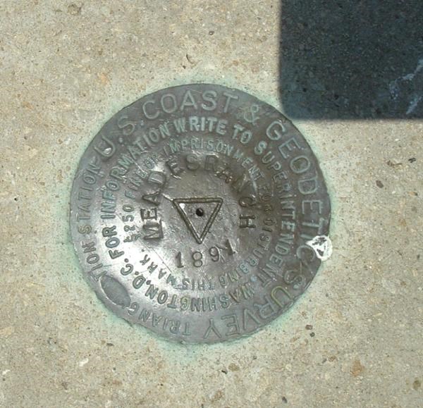
Photo taken by the infamous GEO*Trailblazer 1.
Additional information
Geocaching ID - KG0640 Meades Ranch BM
http://www.geocaching.com/mark/details.aspx?PID=KG0640
(GC9064) Geodetic Center-as close as you get..
by barondriver
GEODETIC CENTER OF THE NATION - Kansas
Historical Markers on Waymarking.com
Bench Marks nearest to Meades Ranch -
information from Geocaching.com
Evie has pictures of the 2005 and 2006 Geodetic Tours on her
website at www.eviewrayartist.com.
Duplicate event information is listed in the forums at the
website for the Kansas Society of Land Surveyors.
A shortened version of the link to this webpage: http://tinyurl.com/2kkwlr
REMEMBER:
- Make the fair trade.
- Log your visit.
- Leave the site better than you found
it.
- Protect the environment —
always.
- Educate those around you.
- Find another cache!
Good luck, and may all your cache dreams
come true.