The photograph below was
taken exactly from the cache hide.
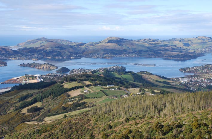
If you do not recognize the
location at once, here is how you can calculate the cache
coordinates:
The photograph was taken
with a film camera through a 50mm lens on 35mm negative.
The left edge of the image
goes exactly through Observation Point, S45º48.836
E170º37.749.
At the centre of the image
you should recognize Peggys Hill,
S45º52.356 E170º37.867. The top of the hill is 17.837mm from the
left edge of the negative.
Just to the right of
Sawyers Bay you might recognize Kilgours Point, and across the harbour is Grassy Point, S45º50.698 E170º36.292.
Grassy Point is 28.827mm from the left edge of the
negative.
Remember that a 35mm
negative is actually 36mm wide, and ignore the curvature of the
earth (the numbers have been adjusted so you can treat this as a
2-dimensional geometry problem). Notice also that the New Zealand
Map Grid is a 2-D coordinate system, while latitude and longitude
are not.
You will find a track
starting from the nearest road, at a location at 116º true from GZ.
If you follow the track carefully, it will take you all the way to
the cache. It’s half an hour to 45 minutes up the hill, a bit less
on the way down. Sturdy shoes with good traction are recommended.
The track improves beyond the cache site, and in about 5 minutes
you will reach an obvious viewpoint with even better all-round
views. It’s best to visit the cache on a fine
day, as the sight is well worth a photograph. It’s not just about
signing the logbook, right?