Comporta do Sal / Salt Gate [Bizorreiro] Traditional Geocache
Comporta do Sal / Salt Gate [Bizorreiro]
-
Difficulty:
-

-
Terrain:
-
Size:  (micro)
Please note Use of geocaching.com services is subject to the terms and conditions
in our disclaimer.
Uma cache fácil, junto às Comportas do Sal / An easy cache, next to the Salt Gates ...
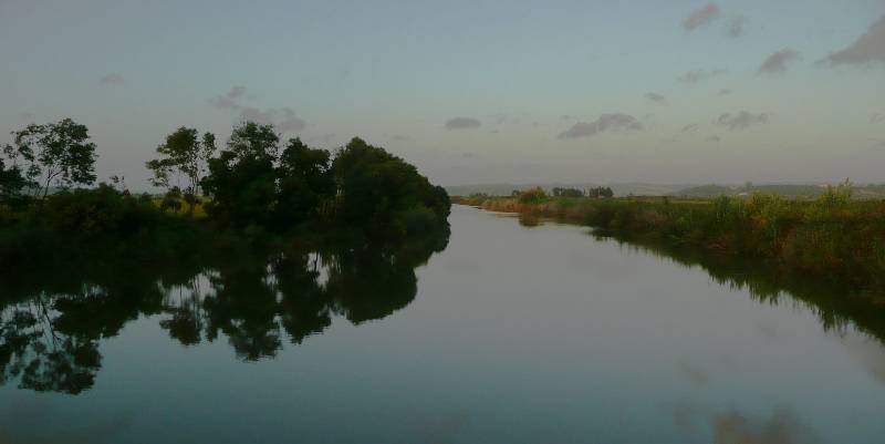
O Vale do Baixo Mondego situa-se na Região da Beira Litoral e corresponde a uma extensa planície de origem aluvial, com cerca de 14.000 hectares, situada entre as cidades de Coimbra e da Figueira da Foz.
As culturas do arroz e do milho ocupam mais de 90% da superfície agrícola útil do Vale. Mas o cultivo do arroz — mais exigente em termos de necessidades hídricas — continua a ser predominante, mesmo em algumas áreas mais a montante (ver Eu já vos dou o arroz! [Montemor-o-Velho]). Este facto levou a adoptar para todo o Vale uma rede de irrigação secundária adaptada à cultura orizícola, possibilitando a sua viabilização sem quaisquer restrições.
O estuário do Mondego está sujeito a um grande stress ambiental devido à descarga de efluentes domésticos e industriais não tratados e à actividade intensiva de orizicultura e aquicultura.
O braço norte é mais profundo (4 a 8 metros versus 2 a 3 m, em preia-mar) e recebe o caudal fluvial do rio Mondego, já que o assoreamento ocorrido na secção montante do braço sul apenas recebe o escoamento fluvial do rio Pranto, que é controlado por comportas destinadas a assegurar as quantidades de água necessárias à orizicultura e a impedir a intrusão de água salina durante a preia-mar (a próposito, ver a Sal da Cobra [Figueira da Foz]').
The Lower Mondego Valley is located in the Beira Litoral Region and is composed of a large flood plain, with an area of around 14.000 hectar, set between the cities of Coimbra and Figueira da Foz.
Rice and corn cultures occupy over 90% of the fertile lands in the Valley. The Rice culture - more demanding in water needs - is still predominant, even in the areas most up river (see Eu já vos dou o arroz! [Montemor-o-Velho]). This led to the adoption of a secudary irrigation grid, adapted to rice needs, allowing its widespread planting without restrictions.
The Mondego estuary is under a great ambient stress due to the discharge of untreated domestic and industrial residues and to the intensive fish and rice farming.
The northern arm is deeper (4 to 8 meters, vs 2 to 3 meters in low tide) and receives the Mondego flow. The southern arm only gets the flow from the Pranto River, controlled by flood gates, built to assure the ammount of water needed for rice growing and to stop the upflow of salt water (btw, see Sal da Cobra [Figueira da Foz]').
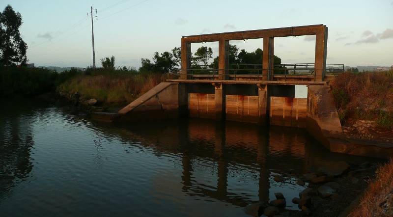
Esta cache vai levá-lo até às comportas da Quinta do Canal, uma vasta área de cultivo, responsáveis pela manutenção dos níveis da água e de salobridade do Rio Pranto.
Para além da sua importância funcional, o local possui uma agradável paisagem. As comportas representam uma fronteira física entre os dois Rios, Mondego e Pranto. As águas da zona são francamente poluídas pelos campos de cultivo, como é comum em outras zonas semelhantes. Apesar disso, a zona é óptima para a observação de aves, canoagem, pesca e os ocasionais banhos. Por vezes, os flamingos marcam também a sua presença na área.
The Pranto river flow depends on the ammount of rain and gate opening. These are opened or closed depending on the need of rice farming, controlling the Rivers height and the ability to irrigate or dry the lands.
This cache will take you to the gates of Quinta do Canal, a large farming area,responsible for the maintenance of water and salt levels in the Pranto River.
Beyond their function, the place provides a pleasante landscape. The gates are a physical border between the Mondego and Pranto Rivers. Due to the heavy farming, the waters are quite polluted. Even so, the area is great for bird watching, canooning and the occasional swim. Sometimes, it's possible to see flamingos in the area.
Esta comporta é também uma ponte, que lhes dará acesso ao caminho para a cache do Moinho das 12 Pedras.
This gate is also a bridge, that will give you access to the road to the 12 Stones TideMill.
Additional Hints
(Decrypt)
[PT] Ahz ohendhvgb, qronvkb qr hzn crqen!
[EN] Va n yvggyr ubyr, haqre n fgbar!