A cache with a view,
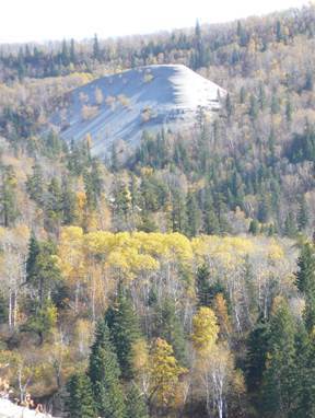
While on your journey look for Bald Hill, a curious natural feature (250 feet above Bald Hill Creek) that can be seen from the trail when there are no leaves on the trees. Near the cache location, there is a spur trail which leads you to the Bald Hill. If you decide to hike to the top of Bald Hill, keep in mind there are several steep sections along the trail that create a good challenge for those who attempt to ascend its slopes (Terrain = 5). Try not to disturb the shale slopes when ascending or descending.
The Escarpment
The escarpment was formed because of the nature of the Riding Mountain shale. The top layer of siliceous shale forms an erosion resistant cap rock. This cap rock, maintains the relatively steep face of the escarpment, collapsing when the softer underlying shale are eroded away. The Manitoba Escarpment runs 675 kilometers across eastern Saskatchewan, western Manitoba and into North Dakota. In places the escarpment rises 427 m (1500 ft) above the Manitoba Plain. During Tertiary times easterly-flowing rivers, such as the ancestral Assiniboine River, have divided the Manitoba Escarpment into a series of uplands that we today call the Pasquia Hills, Porcupine Hills, Duck Mountain, Riding Mountain, and the Pembina Hills.
The Hike
You can hike to Bald Hill either from the Northeast (in yellow) or from the Southwest. Moses and I have not done the hike from the Southwest, but we do plan to do it in the future. Coming from either direction will be about a 14 km total return hike. Here is a map of the hikes.