1ère étape : vous rendre au parking (car park)
Entre Belgentier et Méounes, prendre en direction de
Signes.
Coordonnées du parking : N43°15.7794, E5°57.7977
2ème étape : vous rendre à la chartreuse
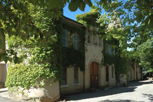
Coordonnées : N43°15.5157, E5°57.9565
Marchez jusqu'à la Chartreuse. [eng] Walk to the
Chartreuse.
Une fois rendu sur place, prenez le temps d'admirer le bâtiment,
puis rendez vous à la fontaine en face de l'entrée principale
(l'eau est potable).
[eng] Contemplate the building and then go to the fountain
facing the main entrance.
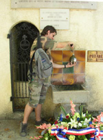
Lisez le panneau : cette fontaine est un des lieux de mémoire de
la résistance durant la 2de guerre mondiale.
[eng] Read the notice : this fountain is an historic place
linked to the history of french resistance during World War
2.
Pour obtenir les coordonées de la cache :
Recherchez la date où eu lieu le rassemblement autour de la
fontaine, et retranscrivez la au format jj/mm/aaaa
[eng]Search for the date of the gathering, and transcribe it in
a jj/mm/aaaa format (jj=day, mm=month, aaaa=year)
Pour calculer les coordonnées de la cache, utilisez le tableau
ci-dessous :
[eng] Use this table to calculate the coordinates of the
cache.
| A1=jj-4 |
A2=(aaaa*4)-805 |
| B1=(mm*mm)-6 |
B2=(aaaa+(jj*mm))+401 |
La cache se trouve en N43°A1.A2,
E5°B1.B2
3ème étape : vous rendre à la cache
Redescendez la route puis bifurquez sur un sentier à droite à
300m.
[eng] Walk back and take a path on the right at 300
meters.
Cherchez la cache avec votre matériel hautement technologique.
Elle se trouve sous un tas de pierre, derrière un arbuste.
N'hésitez pas à vous aider des photos spoiler ... à ce stade là ce
n'est plus de la triche !
[eng]Seek the cache with your hi-tech GPS. It is under some
stones, behind a thin trunk. Don't hesitate to use the spoiler
photos, it's not cheating !