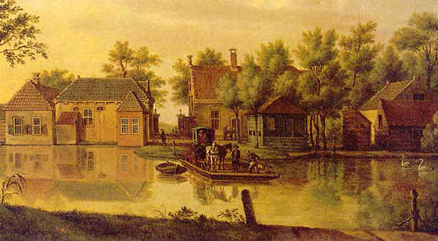
Haagse Schouw met veerpont nabij Valkenburg 1774 (P.C. la Fargue 1729 - 1782)
Haagse Schouw with ferry near Valkenburg 1774 (P.C. la Fargue 1729 - 1782)
Al van oudsher is de Haagse schouw de manier om de Rijn over te steken om van Leiden naar den Haag te komen. Een schouw is een platte pont waarmee mensen, beesten en zelfs koetsen overgevaren kunnen worden. Verderop de weg zijn de tolpoorten te zien waar tot 1912 tol werd geheven voor het gebruik van de weg naar Wassenaar.
De oorspronkelijke herberg werd in het begin van de zeventiende eeuw door Johan van Duivenvoirde ende Wassenaer gebouwd. Nog steeds zijn er een hotel en restaurant gevestigd. Kortgeleden is een nieuw restaurant gebouwd en het oorspronkelijke gebouw is in oude luister hersteld (waypoint HR01).
Already in ancient times the Haagse Schouw was the way to ford the river Rhine to get from Leiden to the Hague. A "schouw" is a flat ferry with which people, animals and even coaches could be taken across. Further on the road one sees the toll gates where until 1912 toll was raised for the use of the road to Wassenaar.
The original guesthouse was built in the beginning of the seventeenth century by Johan van Duivenvoirde ende Wassenaer. Still there are a hotel and a restaurant. Recently, a new restaurant was built and the original building has been completely restored (waypoint HR01).
Vraag: Welk jaartal staat op de voorgevel van het oorspronkelijke gebouw? (A = het jaartal).
Question: What year is written on the facade of the original building? (A = year)
De grote parkeerplaats ligt achter de gebouwen, aan de Valkenburgseweg. Er is nog een tweede parkeerplaats links van het restaurantgebouw aan het water. Vanaf de steiger (waypoint HR02) is een mooi uitzicht over de Rijn naar de buitenplaats Rijnhof.
The large parking area is behind the buildings, along the Valkenburgseweg. There is a second parking lot left of the restaurant building at the water front. From the landing platform (waypoint HR02) there is a beautiful view across the river Rhine to the country house Rijnhof.
Vraag: Hoeveel ramen zijn er in het dak van de koepel? (B = het aantal ramen).
Question: How many windows are there in the roof of the dome? (B = number of windows)
De voorkant van de buitenplaats Rijnhof (waypoint HR03) bereiken we door de brug over de Rijn over te steken en vervolgens linksaf de Rhijnhofweg in te gaan. Aanvankelijk waren langs dit stuk van de Rijn steenbakkerijen. Een van die steenbakkerijen werd door Nicolaas van Kampen, schepen van de stad Leiden, tot buitenplaats gemaakt. De plaats heette Dubbelhof en in 1715 werd de koepel aangebouwd. In 1729 verkreeg de arts Willem Mullius het gebouw en in die tijd kreeg het de naam Rijnhof. Het huis heeft talloze verbouwingen ondergaan en in 1774-5 werd het door Johann Samuel Creutz verbouwd in Louis XVI-stijl. Daarna is het gebouw talloze malen van eigenaar gewisseld tot het in 1908 in bezit kwam van de laatste eigenaresse mevrouw Werndly. In 1908 kwam het hele landgoed in handen van de Hervormde Gemeente van Leiden die er een begraafplaats van maakte. Het herenhuis is sinds die tijd in gebruik als ontvangstruimte en aula tot 1991 waarna het weer werd verkocht, inmiddels als monument. Het gebouw is nu in prive bezit en niet toegankelijk voor publiek.
The front of the country house Rijnhof (waypoint HR03) is reached by taking the near by bridge to cross the river Rhine and then to turn left into the Rhijnhofweg. Originally there were brick works along this part of the river. One of these brick yards was bought by Nicolaas van Kampen, an official from the city of Leyden, who made it into a country house. The house was called Dubbelhof and in 1715 the dome was built. In 1729 the physician Willem Mullius begot the building and named it Rijnhof. The house has been restructured many times and in 1774-5 it was rebuilt by Johann Samnuel Creuts into Louis XVI-style. After that period the house had many owners out of which mrs. Werndly was the last owner. In 1908 the whole estate went to the Reformed Church of Leyden to turn it into a grave yard. From that time on the country house was used as reception room and auditorium until in 1991 it was sold again, now as a monument. The building is now private property and not accessible to the public.
Vraag: Wat is het huisnummer van het buitenhuis? (C = het getal).
Question: What is the number of the country house? (C = the number)
Teruglopend langs de Rhijnhofweg komt men bij een rotonde en links staat een herdenkingsmonument voor de gevallenen bij de verdediging van vliegveld Valkenburg bij de inval in mei 1940 (waypoint HR04). Dienstplichtig soldaat J. Koper is op 10 mei 1940 te Katwijk overleden; zijn naam staat op het monument vermeld.
Walking back along the Rhijnhofweg one comes to a roundabout and on the left side there is a memorial statue for the fallen during the defence of the airport Valkenburg during the invasion in May 1940 (waypoint HR04).
Vraag: Tot welk depot bataljon behoorde de soldaat J. Koper? (D = het depot bataljon nummer).
Question: To what depot battalion belonged the soldier J. Koper? (D = the depot battalion number)
Verder lopend langs de Haagse Schouwweg komt men bij de ingang van de begraafplaats. Hier zijn vele markante Leidenaars begraven, zoals Boudewijn Franciscus Krantz (1884-1933) die bestuurder werd van de lakenfabrieken van diezelfde naam, Koene Dirk Parmentier (1904 - 1948) die met de KLM-Douglas DC2 Uiver van Londen naar Melbourne in Australie vloog, Cees Laseur (1899 - 1960) de toneelspeler en de onkreukbare politicus Maarten van Traa (1945 - 1997)
Continuing along the Haagse Schouwweg one arrives at the entry of the grave yard. Many remarkable residents of Leiden are buried here.
De begraafplaats is beperkt toegankelijk. Raadpleeg deze webstek voor de voorwaarden, toegangstijden en voor informatie over de graven.
The grave yard is not continuously accessible. Consult the above link for conditions, opening hours and for information on the graves.
Vraag: Op de begraafplaats vindt men ook het graf van Oma van Dam (waypoint HR06), de toen oudste inwoonster van Leiden. Hoe oud werd oma van Dam? (E = de leeftijd).
Question: On this grave yard one also finds the grave of Grandmother van Dam (waypoint HR06), in her days the oldest resident of Leyden. How old became Grandmother van Dam? (E = the age).
Teruglopend naar de ingang van de begraafplaats steekt men de Haagse Schouwweg over en loopt men het fiets- voetpad ertegenover in. Bij een parkeerplaats staat links een sporthal die door de week ook in gebruik is bij het CBR.
Walking back to the entrance of the grave yard one crosses the Haagse Schouwweg and enters a cycle- and footpath. Near a parking lot on the left side is a gymnasium that during weekdays is also used for driving license tests.
Vraag: De naam van de sporthal bevat een cijfer. Welk cijfer is dit? (F = het cijfer).
Question: The name of the gymnasium contains a digit. Which digit is this? (F = the digit)
Bij de Smaragdlaan linksaf tot aan de busbaan waar rechts genomen wordt. Voor de brug rechts is de voormalige Engelbertha hoeve (waypoint HR08), nu een appartmentencomplex . Op 25 oktober 1979 legde Bram Favier de eerste steen van het nieuwe restaurant voor zijn Engel. Daarvoor voerde Engel de scepter over hotel Nieuw Minerva aan de Boommarkt te Leiden. In 1981 wordt het restaurant Engelbertha hoeve geopend door burgemeester Goekoop. Na Bram overlijdt Engel in 1992 en het restaurant gaat over in nieuwe handen. Rond 2019 verwerft Stadsherstel Amsterdam het gebouw en zet het om in een appartmentencomplex
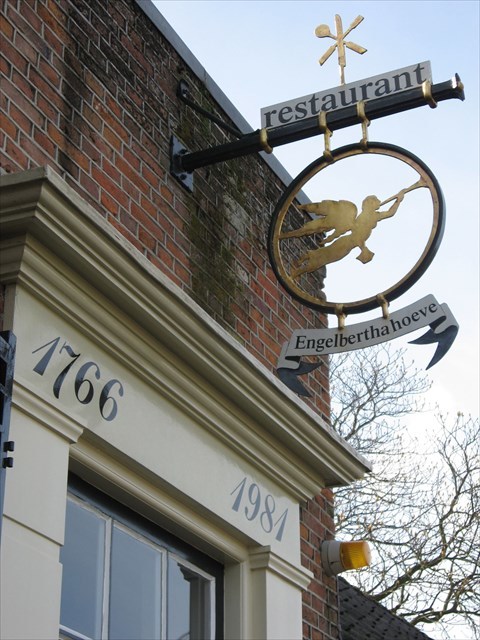
At the Smaragdlaan left to the bus lane where one takes right. In front of the bridge right is the former Engelbertha hoeve (waypoint HR08), now an appartment building. On 25 October 1979 Bram Favier put the first stone of the new restaurant for his Engel (= "angel"). In the year before, Engel ruled the hotel Nieuw Minerva at the Boommarkt in Leyden. In 1981 the restaurant Engelbertha hoeve is opened by the mayor Goekoop. After Bram, Engel passes away in 1992 and the restaurant passes on to a new owner. Around 2019 Stadsherstel Amsterdam acquires the building and turns it into an appartment complex.
Vraag: Uit welk jaar zou het originele gebouw dateren volgens het vroegere opschrift boven de ingang? (G = het jaartal)
Question: From what year dates the original building according to the earlier writing over the entrance? (G = the year)
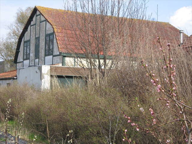
Teruglopen op de Hoge Morsweg naar nummer 111 (waypoint HR09). Verscholen achter een oude tuinderswoning stond een witgekalkte bloembollenschuur met vakwerk en vrolijk geknikte bovenverdieping met rood pannendak; een in Duin- en Bollenstreek vrijwel uniek exemplaar. Op de aanpalende "kwekerij" hebben ten minste zeven generaties van het geslacht Van Egmond hun land- en tuinbouwbedrijf uitgeoefend. Het gebied is opnieuw ontwikkeld maar de bollenschuur is in hernieuwde glorie opgebouwd.
Walk backwards on the Hoge Morsweg to number 111 (Waypoint HR09). Hidden behind an old farm there used to be a whitewashed flower bulb shed with skeleton structure and a inflected roof of red tiles; in this area a unique species. On the nearby nursery at least seven generations of van Egmonds have farmed. The area has been redeveloped and the flower bulb shed has been restored.
Vraag: Hoeveel vensters heeft de bollenschuur op de eerste etage aan de voorkant (vanaf de weg gezien)? (H = aantal vensters).
Question: How many windows has the shed on the first floor on the front side (as seen from the road)? (H = number of windows).
Teruglopend op de Hoge Morsweg komt men bij scheepswerf Akerboom (waypoint HR10), zie hier . Op 1 januari 1927 vestigt de scheepswerf zich aan de Hooge Morschweg, toen nog Oegstgeest. Het bedrijf doet het goed en in 1981 vieren de directeuren C.H. en J.A. Akerboom hun respectievelijke 25- en 50-jarige jubileum. Nog steeds gaat het goed en is het bedrijf bezig met een uitgebreide nieuwbouw.
Walking back on the Hoge Morsweg one arrives at the ship yard Akerboom (waypoint HR10), see here . On 1 January 1927 the warf is installed on the Hooge Morschweg, then still the city of Oegstgeest. The company runs fine and in 1981 the directors C.H. and J.A. Akerboom celebrate there respective 25th and 50th jubilee. Still business is fine and the company is largely being restructered.
Vraag: Tegenover de werf staat een oud schoolgebouw met rechts daarvan de hoofdmeesterswoning. Welk huisnummer heeft de hoofdmeesterswoning? (I = het huisnummer).
Question: Opposite the yard is an old school building with on the right side the headmasters' house. What number has the headmasters' house? (I = the house number)
Verder teruglopend over de Hoge Morsweg komt men bij waypoint HR11, de nieuwe brug over de Rijn. Aan de overkant gaat men linksaf de Rijndijk op, naar het bedrijf Diastatische Producten (*waypoint HR12) dat oorspronkelijk een schoolgebouw was; indertijd behoorde dit deel van Leiden tot Voorschoten.
Continuing along the Hoge Morsweg one arrives at waypoint HR11, the new bridge across the river Rhine. On the opposite side one turns left on the Rijndijk, to the company Diastatische Producten (waypoint HR12), originally an old school building; in those days that part of Leyden belonged to the city of Voorschoten.
Vraag: Hoeveel stenen dragen de dakrand van het witte hoofdgebouw? (J = het aantal stenen).
Question: How many stones carry the roof front on the white washed main building? (J = the number of stones).
De Rijndijk teruglopende de brug voorbij komt men bij de Haagse Schouwkerk (waypoint HR13), gewijd aan Maria Middelares van alle Genaden ; het gebouwtje staat inmiddels op de monumenlijst. Oorspronkelijk was het een houten kerkje van de broeders Montfortanen bij het naastliggende klooster. In 1948 werd het herbouwd en in 1949 gewijd tot parochiekerk voor de omgeving. Nu maakt het deel uit van de Lam Gods-parochie.
Walking backwards pas the bridge one comes to the Haagse Schouwkerk (waypoint HR13), consecrated to Mary of all Mercies; the building is now a monument. Originally, it was a wooden chruch of the friars Monforteans of the nearby cloister. In 1948 it was rebuilt and in 1949 consecrated as a parish church for the environment. Now it is part of the Lam Gods parish .
Vraag: Hoeveel personen zijn uitgebeeld in de sculptuur aan de voorgevel? (K = het aantal personen).
Question: How many persons are displayed in the sculpture on the front? (K = the number of persons).
Van hieruit kan men de schat (cache) gaan zoeken (vul links aan met nullen tot 3 cijfers).
From here one can look for the stash (left pad zeroes until 3 digits).
N 52° 09.X, X = G-A+E+2xI+K
E 04° 27.Y, Y = (B+C+F+H)xJ/K
Let op: de schat is eenvoudig te vinden, geen graafwerk nodig!
Note: the stash is easy to find, no digging necessary!