[EN]
Welcome to
Santalahti
The path goes mainly throught the forest lands and seashores of the
city of Kotka. The whole route is about 4,5 km long. The route goes
throught very variable terrain as bare rocks, forests, seaside and
swamps.

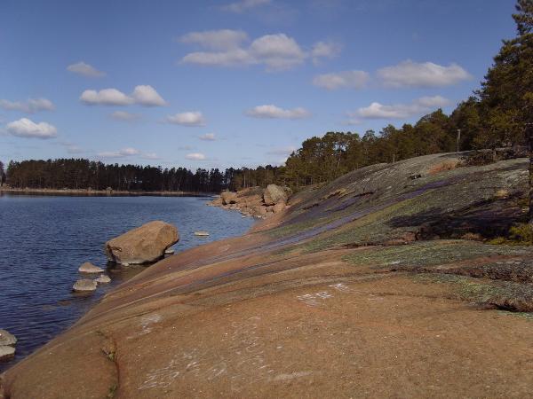
Erratic boulders
A Erratic boulders (glacial erratic) is a piece of rock that
deviates from the size and type of rock native to the area in which
it rests; the name "erratic" is based on the errant location of
these boulders. These rocks were carried to their current locations
by glacial ice, often over hundreds of kilometres. Erratics can
range in size from pebbles to large boulders (more than tousands
tons).
Geologists identify erratics by studying the rocks surrounding
the position of the erratic and the composition of the erratic
itself. Erratics were once considered evidence of a massive flood
approximately 10,000 years ago, similar to the legendary floods
described in the texts of ancient civilizations throughout the
world.
In the 19th Century, many scientists came to favor erratics as
evidence for the end of the last glacial maximum (ice age) 10´000
years ago, rather than a flood. Geologists have suggested that
landslides or rockfalls initially dropped the rocks on top of
glacial ice. The glaciers continued to move, carrying the rocks
with them. When the ice melted, the erratics were left in their
present locations.
In Kotka area there are a lot of erratic boulder who were moved
by glacial ice. This kind of boulder has polished the sharpest
edges. But Kotka´s boulder didn't travel long way. Glacial ice
moved them even dozens of kilometres. Material of erratic and local
rock is same type of granite respectively Rapakivi granite.
Rapakivi
granite
is a hornblende-biotite granite containing large rounded crystals
of orthoclase mantled with oligoclase. The name has come to be used
most frequently as a textural term where it implies plagioclase
rims around orthoclase in plutonic rocks. Rapakivi is Finnish for
"crumbly rock", because the different heat expansion coefficients
of the component minerals make exposed rapakivi crumbly. Rapakivi
is a fairly uncommon type of granite.
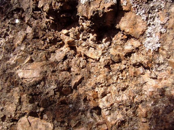
Rapakivi granite
Other location in the World: North and South America, parts
of the Baltic Shield, southern Greenland, southern Africa, India
and China.
Erratic boulders are very common in the Kotka area.
For the valid "cache found"
log:
- you have to upload a photo of:
- a typical example of erratic boulder on the stop 24;
- you with GPS on the rocky shore;
- particular of rapakivi granite (for example on the stop
16).
- And send me via profile e-mail answers to these
questions:
- GPS coordinates of "your" boulder;
- estimate his weight;
- how long was most recent ice age and when
ended.
In supplement there is appended listing in [FR], [DE] and
[FI].
[FI] by Ms. Irina Popenko
Tervetuloa
Santalahtiin
Reitti kulkee pääasiassa metsän kautta ja merenrannalla Kotkan
kaupungilla. Reitin pituus on noin 4,5 km. Reitti on asettu oikein
vaihtelevalla maapohjalla kuin paljakset kalliot, metsät,
merenrannikko ja suo.
Epävakaa kivenjärkäle
Epävakaa lohkare (jäinen epävakaa) on osa kalliosta joka vaihtaa
kokon ja tyyppin paikkan riippuessa. "Epävakaa" (erratic) nimi
merkitsee niiden lohkaren sijainti. Ne kalliot ovat vieneet
nykyiseen sijanniin jäin takia, usein ne ovat levittäneet yli
satoja kilometria. Kivet vaihtelevat kokot nupulalta suurin
lohkareen (yli kuin tuhatta tonnia).
Geologit identifioivat lohkaret lohkaren ympäristön tutkimuksen
tekemässä ja epävakaa kivien kokoelman. Niita kiveja ovat
tunnustuivat aiemmin jykevän tulvan todistuksen noin 10,000 vuotta
sitten, sama kuin legendaariset tulvat, jotka ovat kuvailleet
tekstissamuinisesta kultturista ympäri maailma.
19 -vuosisadassa monta tutkijoita päättivät, että se on enemmän
jääkauden todistus vain tulvan. Geologit ehdottivat maanviremä ja
kallion romahdus alkuaan tipahtuivat kalliot jääkauden huippussa.
Kun jää jatkoi siirtyä, se kantoi kalliot samassa aikassa. Jää on
sulanut ja epävakaa lohkaret jaivat tämähetkisessa sijannissa.
Kotkassa on monta epävakaa lohkareita, jotka ovat vieneet jäin
takia. Tämä lohkaren laji on kiillotettu teräviä reunoja. Mutta
kotkalaisia lohkareita eivat matkustaneet pitkän tien. Jää siirtyi
niitä vain tusinan kilometrin päin. Epävakaa kiven ja paikallisen
kallion aine on sama tyyppinen kuin graniitti tai Rapakiven
graniitti.
Rapakiven
graniitti
On hornblendiitti joka sisältää suuri pyöristetty ortoklaasiset
kristallit. Nimi on käytetty iseimmiten rakenteelliseksi termiksi
jossa se merkitsee plagioklaasisia reunoja ortoklaasisen ympärillä
plutonisessa kallioissa. Rapakivi suomeksi on"raikas kallio" koska
mineralisten komponnentien lukumäärät erilaisessa lämpötilan
laajennuksessa asetti rapakiven murenevaksi. Itse asiassa rapakivi
on epätavallinen graniittin tyyppi.
Muut sijannit maailmassa: Pohja ja Etelä America, osat
itämeren suojalta, eteläinen Grönlanti, eteläinen Africa, Intia ja
Kiina.
Epävakaiset lohkaret ovat tavallisia Kotkassa.
"Aarren löytämiseen"
tarvitset:
- Ladata kuvan:
- tyyppinen esimerkki epävakaisesta lohkaresta on pyysäkilla
24;
- olet GPS systemin kanssa kallioisella rannikkolla;
- erityisesti rapakivi graniitti (esim. pysäkilla
16).
- Lähettää minulle sähköpostitse vastaukset seuravista
kysymyksistä:
- GPS koordinattit sinun lohkaresta;
- arvioi sen paino;
- kuinka kauan kesti äskeinen jääkausi ja millon se
loppui.