N 38° 44.427 W 009°
27.986

The Sun (Latin: Sol) is the star at
the centre of the Solar System. The Earth and other matter
(including other planets, asteroids, meteoroids, comets, and dust)
orbit the Sun, which by itself accounts for about 99.8% of the
Solar System's mass. Energy from the Sun, in the form of sunlight
and heat, supports almost all life on Earth via photosynthesis, and
drives the Earth's climate and weather.
The Sun orbits the center of the Milky Way galaxy at a distance of
approximately 26,000 light-years from the galactic center,
completing one revolution in about 225–250 million years. Its
approximate orbital speed is 220 kilometers per second, plus or
minus 20 km/s. This is equivalent to about one light-year every
1,400 years, and about one AU every 8 days. These measurements of
galactic distance and speed are as accurate as we can get given our
current knowledge, but will change as we learn more.
The Sun is a yellow dwarf star. It comprises approximately 99%
of the total mass of the solar system. The Sun is a near-perfect
sphere, with an oblateness estimated at about
9 millionths, which means that its polar diameter differs from its
equatorial diameter by only 10 km. 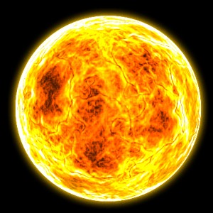 As
the Sun exists in a plasmatic state and is not solid, it undergoes
differential rotation as it spins on its axis (i.e. the Sun rotates
faster at its equator than at its poles). The period of this
actual rotation is approximately 25 days at the equator
and 35 days at the poles. However, due to our constantly changing
vantage point from the Earth as it orbits the Sun, the apparent
rotation of the Sun at its equator is about 28 days. The
centrifugal effect of this slow rotation is 18 million times weaker
than the surface gravity at the Sun's equator. Also, the tidal
effect from the planets does not significantly affect the shape of
the Sun.
As
the Sun exists in a plasmatic state and is not solid, it undergoes
differential rotation as it spins on its axis (i.e. the Sun rotates
faster at its equator than at its poles). The period of this
actual rotation is approximately 25 days at the equator
and 35 days at the poles. However, due to our constantly changing
vantage point from the Earth as it orbits the Sun, the apparent
rotation of the Sun at its equator is about 28 days. The
centrifugal effect of this slow rotation is 18 million times weaker
than the surface gravity at the Sun's equator. Also, the tidal
effect from the planets does not significantly affect the shape of
the Sun.
The Sun does not have a definite boundary as rocky planets do; in
its outer parts the density of its gases drops approximately
exponentially with increasing distance from the centre of the Sun.
Nevertheless, the Sun has a well-defined interior structure,
described below. The Sun's radius is measured from its centre to
the edge of the photosphere. This is simply the layer above which
the gases are too cool or too thin to radiate a significant amount
of light; the photosphere is the surface most readily visible to
the naked eye. The solar core comprises 10 percent of its total
volume, but 40 percent of its total mass.
The solar interior is not directly observable, and the Sun itself
is opaque to electromagnetic radiation. However, just as seismology
uses waves generated by earthquakes to reveal the interior
structure of the Earth, the discipline of helioseismology makes use
of pressure waves (infrasound) traversing the Sun's interior to
measure and visualize the Sun's inner structure. Computer modelling
of the Sun is also used as a theoretical tool to investigate its
deeper layers.
Source: adapted from http://en.wikipedia.org/wiki/Sun
 An
ocean [from Greek Okeanos (Oceanus)] is a
major body of saline water, and a principal component of the
hydrosphere. Approximately 71% of the Earth's surface
An
ocean [from Greek Okeanos (Oceanus)] is a
major body of saline water, and a principal component of the
hydrosphere. Approximately 71% of the Earth's surface  (an
area of some 361 million square kilometres) is covered by ocean, a
continuous body of water that is customarily divided into several
principal oceans and smaller seas. More than half of this area is
over 3,000 meters deep. Average oceanic salinity is around 35 parts
per thousand (ppt) (3.5%), and nearly all seawater has a salinity
in the range of 30 to 38 ppt.
(an
area of some 361 million square kilometres) is covered by ocean, a
continuous body of water that is customarily divided into several
principal oceans and smaller seas. More than half of this area is
over 3,000 meters deep. Average oceanic salinity is around 35 parts
per thousand (ppt) (3.5%), and nearly all seawater has a salinity
in the range of 30 to 38 ppt.
Geologically, an ocean is an area of oceanic crust covered by
water. Oceanic crust is the thin layer of solidified volcanic
basalt that covers the Earth's mantle where there are no
continents. From this perspective, there are three oceans today:
the World Ocean and the Caspian and Black Seas, the latter two having been formed by the
collision of Cimmeria with Laurasia. The Mediterranean Sea is very nearly a
discrete ocean, being connected to the World Ocean through the
Strait of Gibraltar, and indeed several times over the last few
million years movement of the African continent has closed the
strait off entirely. The Black Sea is connected to the
Mediterranean through the Bosporus, but this is in effect a natural canal cut
through continental rock some 7,000 years ago, rather than a piece
of oceanic sea floor like the Strait of Gibraltar.
The deepest point in the ocean is the Marianas Trench located in
the Pacific Ocean near the Northern Mariana
Islands. It has a maximum depth of 10,923 meters. It was
fully surveyed in 1951 by the British naval vessel, "Challenger II"
which gave its name to the deepest part of the trench, the
"Challenger Deep". In 1960,
the Trieste successfully
reached the bottom of the trench, manned by a crew of two men.
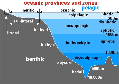 Oceans are divided into numerous regions depending on the
physical and biological conditions of these areas. The pelagic zone includes all open ocean regions,
and can be subdivided into further regions categorized by depth and
light abundance. The photic zone covers the oceans from surface
level to 200 meters down. This is the region where the
photosynthesis most commonly occurs and therefore contains the
largest biodiversity in the ocean. Since plants can only survive
with photosynthesis any life found lower than this must either rely
on material floating down from above (see marine snow) or find
another primary source; this often comes in the form of hydrothermal vents in what
is known as the aphotic zone (all depths
exceeding 200m). The pelagic part of the photic zone is known as
the epipelagic. The pelagic part of
the aphotic zone can be further divided into regions that succeed
each other vertically. The mesopelagic is the uppermost region, with its
lowermost boundary at a thermocline of 12°C, which, in the tropics
generally lies between 700 and 1,000 m. After that is the bathypelagic lying between 10°C and 4°C, or
between 700 or 1,000 m and 2,000 or 4,000 m. Lying along the top of
the abyssal plain is the abyssalpelagic, whose lower boundary lies at
about 6,000 m. The final zone falls into the oceanic trenches, and
is known as the hadalpelagic. This lies
between 6,000 m and 10,000 m and is the deepest oceanic zone.
Oceans are divided into numerous regions depending on the
physical and biological conditions of these areas. The pelagic zone includes all open ocean regions,
and can be subdivided into further regions categorized by depth and
light abundance. The photic zone covers the oceans from surface
level to 200 meters down. This is the region where the
photosynthesis most commonly occurs and therefore contains the
largest biodiversity in the ocean. Since plants can only survive
with photosynthesis any life found lower than this must either rely
on material floating down from above (see marine snow) or find
another primary source; this often comes in the form of hydrothermal vents in what
is known as the aphotic zone (all depths
exceeding 200m). The pelagic part of the photic zone is known as
the epipelagic. The pelagic part of
the aphotic zone can be further divided into regions that succeed
each other vertically. The mesopelagic is the uppermost region, with its
lowermost boundary at a thermocline of 12°C, which, in the tropics
generally lies between 700 and 1,000 m. After that is the bathypelagic lying between 10°C and 4°C, or
between 700 or 1,000 m and 2,000 or 4,000 m. Lying along the top of
the abyssal plain is the abyssalpelagic, whose lower boundary lies at
about 6,000 m. The final zone falls into the oceanic trenches, and
is known as the hadalpelagic. This lies
between 6,000 m and 10,000 m and is the deepest oceanic zone.
Along with pelagic aphotics zones there are also benthic aphotic zones, these correspond to the three
deepest zones. The bathyal zone covers the continental slope and
the rise down to about 4,000 m. The abyssal zone covers the abyssal plains between 4,000
and 6,000 m. Lastly, the hadal zone corresponds to the hadalpelagic zone which
is found in the oceanic trenches. The pelagic zone can also be
split into two subregions, the neritic zone and the oceanic
zone. The neritic encompasses the water mass directly above the
continental shelves, while the oceanic zone includes all the
completely open water. In contrast, the littoral zone covers the region between low and
high tide and represents the transitional area between marine and
terrestrial conditions. It is also known as the intertidal zone because it is the area where
tide level affects the conditions of the region.
Source: adapted from http://en.wikipedia.org/wiki/Ocean