Reka Strela - Pramen
The river Strela – the spring
Prichází na svet a nemá viny.
Zvolna se rozlévá do krajiny.
Matkou je mu zem, po které zvolna stéká.
Rodí se jako pramen a umírá jak reka ......
(Bedrich Ludvík, z titulní písne seriálu Zpet k pramenum)

[CZ]
Reka Strela
Reka Strela pramení pod Prachometským kopcem (andezitová stolová hora) na severním okraji Tepelské vrchoviny v nadmorské výšce 674 m nad morem. Protéká hlubokým údolím a její kanony a zátociny jsou vyhledávány milovníky romantiky. Historicky byla jmenovaná jako Lososnice, Schnella, Sagita ci Šipka. Na své ceste se vlévá do vodní nádrže Žlutice, protéká nejmenším mestem Ceské republiky (Rabštejn nad Strelou), mestem Plasy a vlévá se do Berounky.
Prameny a jejich základní klasifikace
Cást vody, která se dostane v podobe srážek na zemský povrch po nem odtéká a cást se vsakuje do zeme. V zemi voda protéká porézními ci rozpukanými horninami dolu dokud nedosáhne hladiny podzemní vody nebo nepropustné vrstvy. Pokud není hladina podzemní vody vodorovná dochází dále k proudení vody bocním smerem stejne jako pokud narazí na naklonenou nepropustnou vrstvu. Prosakující voda i hladina podzemní vody se muže v urcitých místech dostat na zemský povrch - taková místa pak nazýváme jako prameny. Jako pramen se tedy oznacuje výver podzemní vody na zemském povrchu ale také pod hladinou vody v rekách, jezerech ci morích.
Podzemní voda muže sestupovat propustnými horninami a na nižších místech povrchu muže volne vytékat, muže na povrch pretékat v místech, kde naráží na nepropustné horniny, a nebo vystupuje k povrchu pusobením tlaku. Podle toho se také prameny delí na sestupné a vzestupné.
Sestupné prameny vznikají na místech, kde se nepropustná vrstva nebo hladina podzemní vody sklání ve smeru výveru vody a voda tak vytéká samospádem.
Príklady sestupných pramenu:
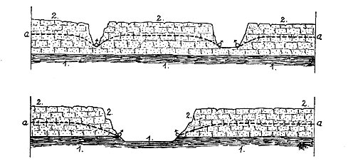
schématické znázornení pramenu roklinových a údolních. 1 = vrstvy nepropustné, 2 = vrstvy propustné, a = hladina spodní vody, # pramen
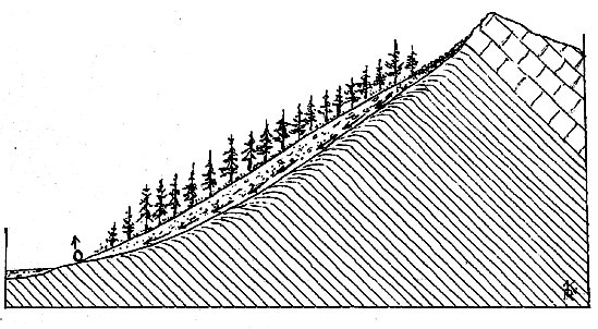
pamen sutový
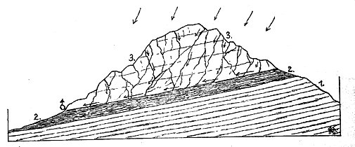
Vrstevný pramen: # vyverající na dolním výchozu naklonené stycné plochy mezi vrstvami nepropustnými 2. a propustnými horninami rozpukanými 3.

Pretékající pramen, vznikající na jednom okraji pánve zvodnených vrstev
Vzestupné prameny vznikají na místech, kde voda vyverá proti smeru gravitace v dusledku pretlaku (zpusobeného napr. plyny) nebo hydrostatického tlaku vyvolaného vodou, která se nachází výše (princip spojených nádob).
Príklady vzestupných pramenu:
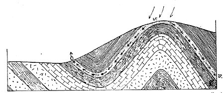
výstupný pramen vyverající pretlakem ze zvodnených vrstev v. v rameni synklináli. Zvodnené vrstvy jsou v podloží i nadloží sevreny vrstvami nepropustnými.

Výstupný pramen vyverající ze zvodnených vrstev v. na poruchovém pásmu pri dislokaci
Krome tohoto zpusobu delení mužeme dále vyclenit napríklad prameny minerální nebo termální (jejich teplota prevyšuje bežné teploty vzduchu).
Earthcache
Aby byl Váš log uznán je zapotrebí splnit následující úkol:
- Vyfotit se u pramene reky Strely.
(Pramen je na soukromé zahrade, ale majitel vás rád k prameni pustí - stací požádat. V prípade, že by jste ho nezastihli, vyfotte se u plotu a cedule obce.)
- poslat mi zprávu s odpovedmi na otázky:
1) Jak dlouhá je reka Strela? (± 5 km)
2) Jaký je výškový rozdíl mezi pramenem Strely a soutokem s Berounkou? (± 5 m)
[EN]
The river Strela
The river Strela has got a spring under the hill Prachometsky (that is an andesite mesa) at the northern edge of the Tepelska vrchovina (the Tepelska Highlands) in the altitude of 674 metres above the sea. The river goes through a deep valley and its canyons and meanders are sought out by lovers of romance. In history the river had different names such as the Lososnice, the Schnella, the Sagita or the Sipka. The river issues into the Zlutice dam on its way. It flows through Rabstejn nad Strelou, the smallest town in the Czech Republic. Then it passes through the town called Plasy and discharges into the Berounka river.
Water springs and their basic classification
A part from water, which lands in a form of rainfall, flows off the Earth´s surface. Another part soaks into the soil. This water goes through porous or cracked rock below the ground until it reaches the level of subterranean water or impervious layer. Leaking water or even the level of subterranean water can get at certain places on the Earth´s surface. These places are called springs. Therefore the headspring of subterranean water on the Earth´s surface but also under the water level in rivers, lakes or seas is labelled as a spring.
Subterranean water can descend through pervious rock and in the lowest places it can flow out freely. It can also overflow at places where water bumps into impervious rock and it can ascend to the surface because of pressure. According to this logic we divide springs into two groups - descending springs and ascending springs.
Descending springs emerge at places where impervious layer or the level of subterranean water slopes in the direction of the water headspring and then water flows out by gravity.
The examples of descending springs:
Schematic representation of ravine and valley springs. 1= impervious layers, 2= pervious layers, a= the level of subterranean water, # spring
Debris spring
Stratified spring: # flowing out at the bottom outcrop of sloping contact surface between impervious layers 2. and pervious cracked rock 3.
Overflowing spring, emerging at one edge of a basis of aquiferous layers
Ascending springs emerge at places where water flows out against gravitation because of excess pressure (caused by e.g. gas) or hydrostatic pressure initiated by water that is situated higher (principle of connected vessels).
The examples of ascending springs:
Ascending spring flowing out because of excess pressure from aquiferous layers v. in the arm of syncline. Aquiferous layers are surrounded both in subsoil and overlying rock by impervious minerals.
Ascending spring flowing out from aquiferous layers v. at the area liable to break down thanks to dislocation
Apart from this classification we can further highlight mineral springs and thermal springs (their temperature exceeds the common air temperature).
Earthcache
Your log will be accepted when you fulfil the following tasks:
- Take a photo of yourself at the river Strela´s spring.
(The spring is situated in the private garden but the owner is willing to let you in. Just ask. In case he is not at home, take a photo at his fence and at the notice of the village.)
- Send me a message with answers to these questions:
1) How long is the river Strela? (± 5 km)
2) What is the difference in height between the Strela´s spring and the junction of the Strela and the Berounka rivers? (± 5 m)
Cache je soucástí série Reka Strela, jednotlivé cache jsou umísteny v bezprostrední blízkosti reky nebo s výhledem na ní.
Cache is the part of the River Strela´s series.
RS #1 - Pramen
RS #2 - Smírcí kríž
RS #3 - Prehrada Žlutice
RS #4 - Vyhlídka u Chyše
RS #5 - Mlýny a Hamr
RS #6 - Prehrada Plasy
RS #7 - Doubrava
RS #8 - Finále
Cache je soucástí projektu " K pramenum " nebo stránky autora zde.

Tady mužete tuto cache ohodnotit.