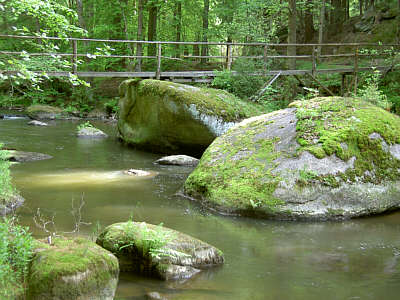
the Waldnaab valley
The wild and romantic nature reserve Waldnaabtal, which takes up 180 hectares, reaches from Falkenberg to Windischeschenbach. The river bed with its many alders is edged by quaint granite rocks, reaching up to 30 meters high. Due to several hiking trails, the area is easily accessible and a textbook example for the effects of exogenous forces on granite.
The Waldnaab valley is a station of the “GEO-TOUR Granite”, which was founded by the Geocentre Windischeschenbach in cooperation with the Bavarian state office for geology. The valley will also been added to the list of Bavarian’s 100 most beautiful geotops (Geotop-Nr. 377R013).
source: GEOPARK Bayern
Geological information
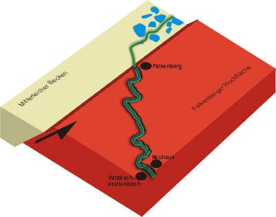
The Waldnaabtal is a valley that, at 12 km length and similar to a canon, ranges the plateau of granite surrounding the Falkenberg. By cutting into the ground quite like a saw blade, the Waldnaab manages to balance the elevation of the Falkenberg block; preferably following the loose areas of the granite, such as the subverted ones. Hence, the partly right-angled course of the river can be explained (see image).
source: GEOPARK Bayern
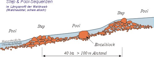
Step & Pool sequences
The repetitive sequences of rock agglomerations and mostly unblocked parts of a river are called step and pool sequences. They are a natural phenomenon in any flowing waters carrying rock like material. With their help, the river can regulate its flow on its own.
source: GEOPARK Bayern
The hike
Park at one of the many hiking trail parking lots, such as at one of the following:
| P1 |
N49 51.382 E12 10.437 |
| P2 |
N49 51.496 E12 12.750 |
| P3 |
N49 50.414 E12 10.827 |
| P4 |
N49 48.687 E12 10.080 |
Start your hike to the following 7 waypoints:
| WP1 |
N49 51.230 E12 11.778 |
| WP2 |
N49 51.131 E12 11.477 |
| WP3 |
N49 50.946 E12 11.354 |
| WP4 |
N49 50.577 E12 11.342 |
| WP5 |
N49 49.844 E12 11.414 |
| WP6 |
N49 49.707 E12 11.356 |
| WP7 |
N49 49.493 E12 11.652 |
Depending on where you start and which route you take, the way is between 10 and 20 kilometers long. You can also reach every stop with your bike – preferably a mountain-bike.
The different stops
During your hike you will pass all of the stops listed below: they are worth seeing and given in random order. Write down at which waypoint you saw what, and remember the solutions for the bonus tasks. Don’t forget to take the pictures that two of the stops will ask you to!
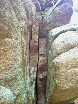
Picture A - "Butter tub" (Butterfass)
A kolk (also known as colc) is an underwater vortex that is created when rapidly rushing water passes an underwater obstacle in boundary areas of high shear. High velocity gradients produce a violently rotating column of water, similar to a tornado. Kolks are capable of plucking multi-ton blocks of rock and transporting them in suspension for some thousands of meters.
Kolks leave clear evidence in the form of plucked-bedrock pits, called Rock-cut basins or lakes and downstream deposits of gravel-supported blocks that show percussion but no rounding.
Note down the number of the steps in the rock!
|
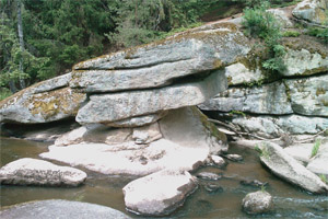
Picture B - "Anvil" (Amboss)
This protruding rock of granite is a textbook example for fluvial cuts.
Take a picture of you and your GPS in front of the rock!
|
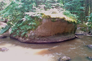
Picture C - "Tablestone" (Tischstein)
It is said that at the beginning of the 19th century the passing Napoleonic troops tried to pull the top down by using 120 horses. They were, however, unsuccessful.
Don’t forget to take a picture of you and this rock!
|
Picture D - "Packed wagon" (Kammerwagen)
The square rocks and the entire structure resemble a greatly packed wagon. Therefore, in former times the second “wagon” was called “wedding procession”, carrying the bride’s endowment in big chests.
|
Picture E - "Glacial mill" (Gletschermühle)

An impressive example for the eroding qualities of water. The name is confusing, for this hole has nothing to do with glaciers. But the similarity with alpine glacial mills is striking.
Remember the diameter of the hole!
|
Picture F - "Memorial stone" (Gedenkstein)
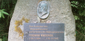
This memorial stone is dedicated to Ferdinand Windschiegl, the „father of the Waldnaab“.
Note the date of the erection!
|
Picture G - "Acid well" (Sauerbrunnen)
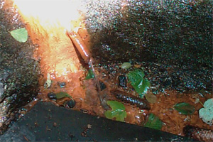
The rosset color that can be seen on the rock results from precipitated iron minerals. Carbonic acid from the water rises, and, on its way, solves many minerals, such as iron.
|
The tasks:
- - Assign the correct pictures to the waypoints WP1 to WP7.
- - Which diameter does the hole of the glacial mill (Gletschermühle) have?
- - How many steps lead up to the Butter tub (Butterfass)?
- - What is the date of erection of the memorial stone (Gedenkstein)?
- - (additional logging requirement on voluntary basis) Publish, along with your log entry, the photos that depict you and your GPS in front of the table stone (Tischstein) and the anvil (Amboss).
Please email me the answers using my geocaching.com-profile or fill in the online form on our homepage.
Log entries which do not fulfill the required tasks will be deleted!
Further links:
Bavarian – Bohemian Geopark – Europe’s geological center
http://www.geopark-bayern.de/Public/GeoTourGranit/Waldnaabtal.htm
Friends of mineralogy and geology in Weiden
http://www.vfmg-weiden.de/min.htm
Waldnaabtal in Wikipedia
http://de.wikipedia.org/wiki/Waldnaab
 A German version of this text is available on our homepage! - Auf unserer Homepage gibt es diesen Text auch auf Deutsch!
Viel Spass beim Suchen!
Happy caching!
reindeer