Lone Peak EarthCache
-
Difficulty:
-

-
Terrain:
-

Size:  (other)
Please note Use of geocaching.com services is subject to the terms and conditions
in our disclaimer.
Lone Peak
Elevation 11,253 feet
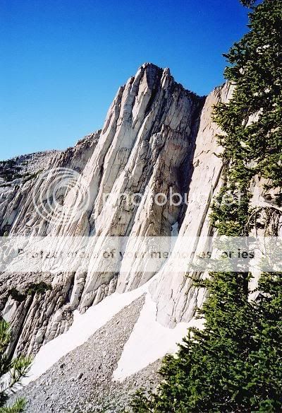
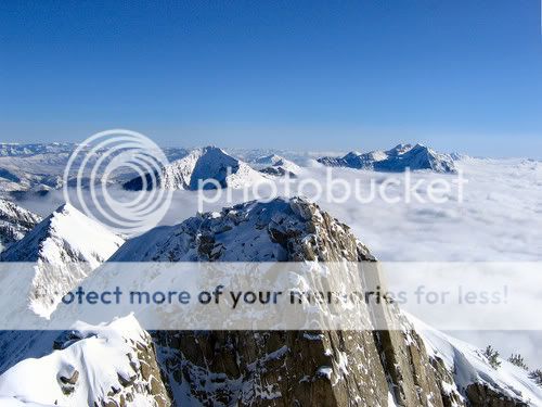
Located in the heart of the Lone Peak Wilderness Area, the Lone Peak summit is rather unique in the Wasatch. It features jagged, gray granite composition, unlike any mountain in Utah, really. The sheer 650+ foot face is a classic rock climb, a favorite of climbers willing to make the rugged approach. Spectacular and easily accessed, the Wilderness Area even has a few lakes, the most well known of which is Lake Hardy.
The product of 20 million years of geologic faulting, volcanic activity, and glaciation, the Wasatch Mountains, the western range of the Rocky Mountains, stretch across Utah from the Bear River in the north to Mount Nebo near Nephi in central part of the state. Most elevations along the range are generally between 9,000 and 10,000 feet; Mount Nebo is the highest peak at 11,877 feet. Some of the other significant peaks from north to south include Willard Peak, Mount Ogden, Bountiful Peak, Mount Olympus, Lone Peak, Mount Timpanogos, Provo Peak, Spanish Fork Peak, and Loafer Mountain.
Uplifting of the Uinta Mountains and downwarping of the Uinta Basin resulted from the creation of the Rocky Mountains. Smaller uplifts created such scenic attractions as Waterpocket Fold, the San Rafael Swell, Monument Upwarp, and the Circle Cliffs anticline. Lakes occupied large basins east of the Wasatch line. The Green River lake beds were in one of these basins, and now are an important source of oil and oil shale. Much of the area not covered by these lakes eroded.
Regional uplift of much of the western North American continent raised Utah to its present elevation, on average about one mile above sea level. Steepened river gradients greatly accelerated erosion, and several rivers still sculpt the great canyonlands of the Colorado Plateau and carry incredible volumes of sediment to the Colorado River toward the Gulf of California. As the western coast of the North American continent moves slowly westward relative to the continent east of the Wasatch line, the east-west stretching has broken the crust along north-south faults, creating elongated basins and ranges, disrupting drainages, isolating mountain ranges, and creating closed basins that have been filling with sediments ever since. Active faults such as the Wasatch fault accommodate this stretching and tilting in jarring, potentially destructive readjustments called earthquakes. Volcanism continues, particularly in southwestern Utah. Substantially cooler and wetter climate periods created glaciers at high elevations and lakes in basins. One such was Lake Bonneville, which reached its highest level, in places more than 1,000 feet deep, about 15,000 years ago. Significantly drier conditions intervened. Today we live in one of the drier periods. The glaciers have retreated and hotter conditions have almost dried up the extensive lakes, leaving the Great Salt Lake as the largest remnant of the lake that once covered most of northwestern Utah.
The geologic structure of the area is varied and complex, consisting of granitoid rock masses and several sedimentary formations. Much of the higher elevation is alpine, characterized by large, open cirque basins and exposed rocky ridges. A few small natural and reservoired lakes add to the scenic beauty.
To log this Cache you must Visit the location then E- Mail me some observations.
What are the two causes of the formation and shaping of the Lone Peak Area.
What is the evidence of your observation?
OPTIONAL: Post a photo of you and your group on the cache page.
We will be fair in our Judging.
Additional Hints
(No hints available.)