This hike can also be started at Roque de las Muchachos where
the GR 131 (red/white) starts towards Somada Alta, but we
start at a point located further on where the GR crosses the
road.
Following the path you will soon pass by
 .
.
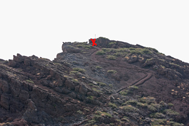
Continu up and down and before reaching the cachelocation this
will be your route:
 .
.
Once you reached and found the cache enjoy the marvellous views
 and either return the same way or continue towards our next cache
on top of Roque Palmero!
and either return the same way or continue towards our next cache
on top of Roque Palmero!
Take about 1.5 hours time for this route.
BTW: This is a high mountaineous area where the sun can be
burning much stronger than down on the beaches. Be sure to use
a good sunprotection. Wear good hikingboots en carry plenty of
drinks . Especially when you also go for Roque Palmera !!
Rother Wanderfuhrer, 2008 , hike nr.61 describes the route as
going to Somada Alta.
Enjoy !
RedRocks.
Many thanks to Ruth and Horst , Kangoo for helping maintain
this and other caches!