 View from the top clearly showing Tukituki River
There are a number of short walking trails through the Te Mata Peak Trust Park (approximately one hour each way). Plus there are some great mountain bike trails. For the purposes of this EarthCache though, you are able to drive almost to the top, with just a short uphill walk to the summit.
Te Mata Peak is a “Hogs Back” ridge of erosion resistant limestone dipping steeply to the west. Across the Tukituki Valley immediately to the east is another limestone rock ridge. These sedimentary rocks, originally deposited in horizontal layers on the seabed, have been tilted and bowed upwards by the geological forces generated by the collision of the Pacific and Australian tectonic plates. The features of Te Mata peak are a consequence of the earthquake fault which runs from Wellington in the south, through the Ruahine range to the Hawkes Bay.
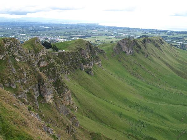 The Limestone "Hogs Back" ridge
History
Te Mata Peak “Te Mata o Rongokako” is land originally settled by Ngati Ngarengare a sub tribe of Ngati Kahungunu. The land that makes up the Te Mata trust park was included in a block purchased in 1862 by John Chambers. In 1927 his son gifted the 98 hectares which make up the park to the people of Hawkes Bay.
Geology
This land district separates readily into three regions of geological structure; the main forms of the eastern Wellington district are continued into Hawke's Bay. The western boundary is formed by high, rugged mountain ranges running south-west — north-east and composed of Triassic-Jurassic greywacke. The east is characterised by broken, hilly country formed from Cretaceous and Tertiary sediments. Here complex earth movements have upthrust small ridges or tilted blocks, exposing anticlinal cores of late Cretaceous rocks. The third region, which is a continuation of the wide Wairarapa trough from Woodville through the Takapau Plains to Mohaka and Wairoa on the shore of Hawke Bay, is filled with thick Upper Tertiary and Pleistocene sediments. The land district lies within the zone of active crustal instability.
The range as a whole has been pushed up along major faults to the east and west. The active Wellington Fault, continuing from further south, lies along the eastern edge of the range, while numerous other small faults, also active, are present. Earthquake tremors are frequent in this area and surface movements have occurred on many of the faults.
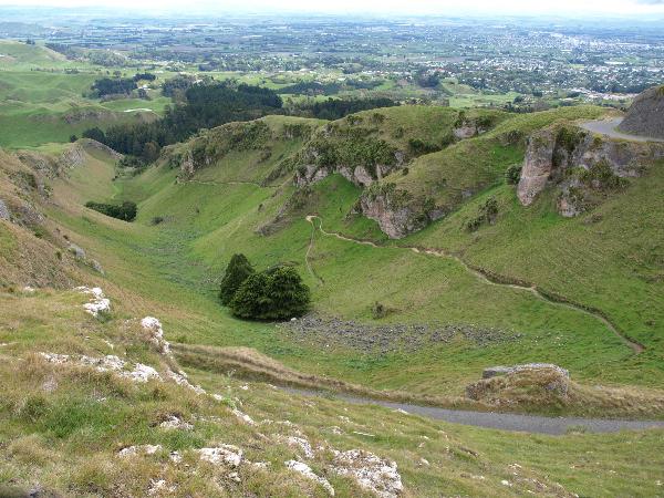 View of the ridge from the opposite direction
Greywacke similar to that of the Ruahine Range probably underlies most of the area to the east of the range, as is shown in diagram 5. Tilting movements along faults have exposed this basement greywacke in a number of places (for example, Waewaepa and Wakarara Ranges), but here it is only moderately folded and faulted and is possibly younger than the Ruahine greywacke. Further east again (for instance, in the Otane Range) the basement greywacke is not itself exposed, and the oldest rocks at the surface are Lower Cretaceous fossiliferous sandstones with local patches of grits and conglomerates, deposited in basins developed after the Rangitata Orogeny.
Spilites, with their associated red shales and jaspers, occur widely in the Hawke's Bay greywackes, and at Maharahara they contain small quantities of copper, which was worked for a short time.
The coastal series of low ranges and hilly country forming the second region run parallel to the Ruahine axis, from Mahia to Palliser Bay in the Wairarapa, bordering and projecting into the Wairarapa — Hawke Bay — Wairoa trough. Structurally the much folded and faulted late Cretaceous and Tertiary sediments of the coastal zone form a complex fold system trending north-east — south-west The Akitio Syncline lies inland, running parallel to the southern Hawke's Bay coastline and ending at Hastings. Along the seaward side are complexly faulted, tilted, and folded strata, mainly of massive mudstones which form a number of parallel anticlines and synclines. The striking hogback of the Silver Range north of Elsthorpe is composed of alternating sandstones and mudstones of Miocene age. Kahuranaki is a complexly faulted mass of upper Pliocene cemented shelly limestone, and Te Mata Peak is part of a prominent dip slope in the same limestone on the west flank of the Elsthorpe Anticline. The limestone forms prominent dip slopes throughout central Hawke's Bay and is often quarried for agricultural use; very occasionally some layers are pure and are used in glass manufacture (for example, Pakipaki, Waipawa Gorge, etc.). Fossils are abundant in most of the Tertiary rocks of the district; the Dannevirke Series is based on the sequences exposed near Te Uri and Waipawa. The late Cretaceous rocks do not contain many fossils, but New Zealand's largest ammonite (2 ft in diameter) was found near Porangahau.
The Wairarapa Fault Zone continues into this region of Hawke's Bay District and many active faults are known. Earthquakes of considerable intensity are frequent in the region and the Napier earthquake of 1931, which devastated the city of Napier, raised the sea bed at Ahuriri 7–9 ft to form dry land, now used by industry and housing. The Pahiatua earthquake of 1934 occurred in the same fault zone and the Wairoa earthquake of 1932 in the continuation of the zone on the northern side of Hawke Bay.
Mythology
Centuries ago the people living in pa (fortified villages) on the Heretaunga Plains were under constant threat of war from the coastal tribes of Waimarama. At a gathering in Pakipaki (5km south of Hastings) to discuss the problem, the solution came when a wise old woman (kuia) sought permission to speak in the marae. "He ai na te wahine, ka horahia te po, " she said. (The ways of a woman can sometimes overcome the effects of darkness).
Hinerakau, the beautiful daughter of a Pakipaki chief, was to be the focal point of a plan. She would get the leader of the Waimarama tribes, a giant named Te Mata, to fall in love with her, turning his thoughts from war into peace. The plan succeeded, but she too fell in love.
The people of Heretaunga, however, had not forgotten the past and with revenge the motive, demanded that Hinerakau make Te Mata prove his devotion by accomplishing seemingly impossible tasks. The last was to bite his way through the hills between the coast and the plains so that people could come and go with greater ease.
Te Mata died proving his love and today his half-accomplished work can be seen in the hills in what is known as The Gap or Pari Karangaranga (echoing cliffs). His body forms Te Mata Peak, the legend says. At sunset one can often see, in the mists which stretch from the crown of Kahuraanake, the beautiful blue cloak with which the grieving Hinerakau covered the body of her husband before leaping to her own death from the precipice on the Waimarama side of the peak. The gully at the base of the cliff was formed when her body struck the earth.
Once you complete the following EarthCache requirements you can post your find without delay, as per the EarthCache guidelines. You will also need to verify your find by sending us a message with your answers to these questions and we will answer in due course:
1. Use the text "Te Mata Peak" - GC1JPG7 in your email.
2. At the GZ is a trig station. What is the bench mark number of this trig?
3. Place your GPS on the foundations of the trig. What is the altitude here?
4. The viewing area surrounding the GZ was developed in what year?
5. (Optional). Take a picture of yourself at the trig holding your GPS. (Just post the photo with your log – no need to email this)