Big Pinnacle EarthCache
-
Difficulty:
-

-
Terrain:
-

Size:  (not chosen)
Please note Use of geocaching.com services is subject to the terms and conditions
in our disclaimer.
The Grayson Highlands Park is on U.S. 58 midway between
Independence and Damascus. The Park entrance is 8 miles west of
route 16 on US 58. Both trails to the cache are moderate with the
Twin pinnacles Trail being the easiest.

The Big Pinnacle
The 4,935-acre Grayson Highlands State Park showcases the
Natural beauty of waterfalls, red spruce-fir forests and igneous
rock outcroppings such as the Buzzard's Rock , Listening Rock and
the Big and Little Pinnacles. Native trout streams, rugged
mountains, and high alpine meadows with panoramic vistas of valleys
below are features of the Park. A community of hardy wildflowers,
shrubs, insects, birds, amphibians, and mammals that can withstand
the harsh conditions of the open highlands have adapted to life in
the alpine meadows.
Very few people know that the Mount Rogers chain with the
surrounding mountain peaks are remnants of ancient volcanoes.
Roughly 750 million years ago, rift-related (divergent) volcanoes
erupted along part of the axis of what was to become the
Appalachian Mountains. The major peaks of the Mountain Rogers Chain
are: Mount Rogers, Pine Mountain, Whitetop Mountain and the Haw
Orchard Mountain with it’s Twin Pinnacles. Mount Rogers is the
highest peak in Virginia at an elevation of 5729 feet. The Mount
Rogers chain occupies about 206 square miles. This Earthcache is
about one of those high peaks of the Mount Rogers chain………..The
Big Pinnacle of Grayson Highlands.
Because of the volcanic activities of the Mount Rogers
Chain, its geological history is very different from most of the
Appalachian Mountains. Peaks and outcroppings on most ridges of the
‘Appy” mountains are definitely sedimentary rock. The sedimentary
rock is predominately limestone with sandstone/shale found in the
more northern areas. The volcanic eruptions have left major igneous
formations. These formations have been weathered by millions of
years of wind and rain.

The Formation Of Igneous
Rocks
The Big Pinnacle is a wonderful outcropping with a
panoramic view of Massie Gap and it proudly looks on it’s two
higher neighbors, Mount Rogers and the Little Pinnacle. The Big
Pinnacle is found on the Haw Orchard Mountain along with the
Little Pinnacle and Buzzard’s Rock.
Instead of the usual gray of limestone or the rust color of
sandstone, the igneous outcroppings vary from red to pink with
streaks of white quartz and some purple/amber variations. What is
this ‘igneous rock?
Igneous rock is from magma. Because of that, it is often
referred to as ‘Fire Rock”. Igneous rock is classified in many
ways. Among the methods of classification are: where it was formed
(above or below the surface); color/texture (dark/black to reds to
light/gray) ; mineral composition (amount of quartz, feldspar,
plagioclase, etc. present) and chemistry such as silica saturation,
the alkali index and iron enrichment.
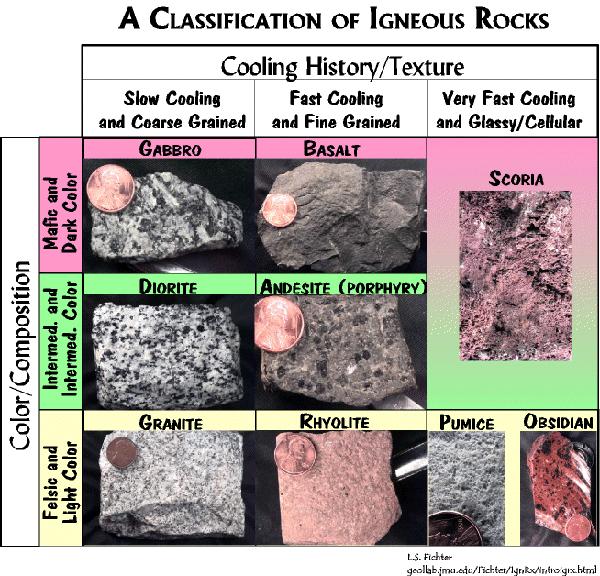
Igneous rocks are either intrusive or extrusive. Intrusive
are igneous rocks that were formed below the surface of the Earth.
Some examples of intrusive igneous rocks are: granite, diorite and
gabbros. These rocks are course grained especially when compared to
their extrusive fine grained cousins. Some examples of extrusive
igneous rocks are basalt, andesite and rhyolite with rhyolite being
the most commonly found rock on the Mount Rogers peaks. Rhyolite is
considered to be the extrusive equivalent to the plutonic granite
rock and consequently outcroppings of it often bear a strong
resemblance to granite. The Big Pinnacle is largely
rhyolite.

Ryolite
There are two ways to reach the Big Pinnacle and other
wonderful areas to see. The ‘easy’ way is to drive to the Visitors
Center and take the Twin Pinnacles Trail (Red Blaze) that is behind
and to the left of the Center. Along the way, enjoy the Little
Pinnacle, Massie Gap Overlook and of course, the Big Pinnacle. This
trail is a 1.6 mile easy loop. The only caution is that during
snowy/winter times the gate at Massie Gap is often locked which
prevents the drive to the Visitors Center.
An alternative route is to park at the Massie Gap parking
area and take the Big Pinnacle Trail (Yellow Blaze) which is
directly across the road from parking. Look for the sign and yellow
trail marker. Follow the Big Pinnacle Trail for approximately .4
mile to where it joins the Twin Pinnacles Trail (Red Blaze) just
below the summit of the Big Pinnacle. After reaching the Big
Pinnacle go back down to the Twin Pinnacles Trail and follow it to
the Little Pinnacle and the Visitors Center. To visit the Buzzard
Rock and Listening Rock head right along the road in front of the
Visitors Center to the picnic area on the left. Here you will find
the boardwalk that is immediately next to the Buzzard Rock and the
yellow blazed Listening Rock Trail. The Listening Rock trail takes
about 45 minutes to complete the lop and return to the Visitors
Center Parking area. From here, you may ‘back track’ to Massie Gap
via the Twin pinnacles and Big pinnacles trails or follow the main
road down to the Massie Gap parking area and where you started! It
is about 1.0 miles downhill to Massie Gap by following the
road.

Big Pinnacle Trail Marker
In order for you to claim a find please post a picture of
yourself (entire party) with GPS in hand. Also make sure that the
Big Pinnacle is in the background. Please email us the
answers to the following questions: 1. What is the elevation of the
Big Pinnacle and 2. What are the predominant colors of the
rhyolite rocks found at the Big Pinnacle?
We hope you enjoy the visit to one of the most geologically
interesting parks in Virginia. Take the camera for far more
enjoyment than satisfying the photo requirements of the
cache.
This Earthcache was approved by the
Geological Society of America
| We have earned GSA's highest
level: |
 |
Additional Hints
(Decrypt)
Ubyq ba gb lbhe ung ohg qba'g whzc bss gur Ebpx!