LA MURALLA ARABE DE MADRID
SITUACION:

Historia: Fue construida por los musulmanes en el siglo IX
Descripción: Dentro del recinto amurallado árabe se encontraban el alcázar, la mezquita y la casa del gobernador o emir.
El recinto contaba con tres puertas: la puerta de la Mezquita o Arco de Santa Maria, qué comunicaba el recinto militar con la parte civil que vivía fuera de la fortificación, la puerta de la Vega, qué daba a la vega del rio Manzanares y a los caminos de Castilla y Extremadura y la puerta de la Sagra (Xagra o Campo), qué daba a las huertas y al campo.
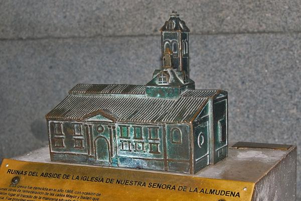
Las coordenadas iniciales te conducirán a una calle donde un extraño personaje mira las ruinas de la antigua iglesia de Santa María de la Almudena, primera iglesia del Madrid cristiano, edificada en el solar que ocupaba la antigua mezquita musulmana.
Mira arriba,alrededor, una placa amarilla recuerda que en este lugar fue asesinado un individuo en el año 1BCD.
Ahora, usa los dígitos del año para calcular las coordenadas reales
Las coordenadas del caché son:
N 40º 24.(D+1)(C-D+1)(D-C)
W 003º 42.(D)(B+2)(C-B)
¡Cuidado con los muggles!
THE ARAB WALL OF MADRID
LOCATION:
History : Was constructed by the Muslims in the 9th century.
Description : Inside the walled Arabic enclosure, there was the fortress, the mosque and the house of the governor or emir.
The precinct has three doors: the door of the Mosque or Arco de Santa María, what was communicating the military area with the civil part that was living out of the fortification the door of La Vega , open to the fertile plaine of the river Manzanares and to the ways of Castile and Estremadura and the door of the Sagra (Xagra or Campo), open to the gardens and to the country.
The initial coordinates will lead you to a street where a strange personage looks at the ruins of the former church of Santa Maria de la Almudena, the first church of the Christian Madrid, built in the lot that was occupying the former Moslem mosque.

Now look up left, a yellow plate remembers that in this place a man was murdered on monday, in the year 1BCD.
Use the figures of the year to calculate the real coordinates
The coordinates of the cache are:
N 40º 24.(D+1)(C-D+1)(D-C)
W 003º 42.(D)(B+2)(C-B)
Be careful with the muggles!