EarthCache Basaltgang Rabenlay
An der Rabenlay zwischen Oberkassel und Ramersdorf wurde früher Basalt als widerständiger Baustein abgebaut.
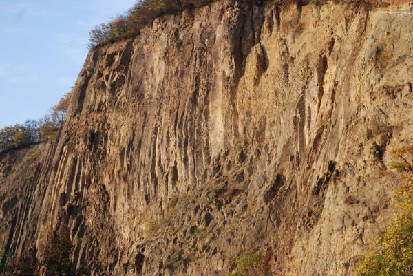
Heute liegen die Brüche still. Die Felswände mit ihren schlanken Basaltsäulen gehören längst zum Landschaftsbild.
Eine tiefreichende Spalte bildete den Aufstiegsweg für die glutflüssige Basaltschmelze.
Die Basaltlava drang durch die teilweise 200m mächtige Schicht der Trachyttuffe an die Oberfläche.
Neben dem Basaltgang befindet sich das Grund- und Deckgebirge.
Das Grundgebirge aus gefalteten Tonschiefern und Sandsteinen des Unterdevon bildet den tieferen Untergrund.
Darüber befinden sich flach liegend die im Tertiär und Quartär abgesetzten Schichten ( Deckgebirge).
Aufgrund von Erbewegungen haben diese jedoch beiderseits des Basaltganges unterschiedlich Höhen.
Die Basaltsäulen entstehen bei langsamer Abkühlung der Schmelze.
Früher befand sich der Rhein an der Oberkante des Basaltganges und sank über die Zeit hin bis zu seinem jetzigen Bett.
Der harte Basalt blieb auf der Talflanke als steil geböschter Felsen stehen.
Für den Cache beantworte mir folgende Fragen an Stage 1:
1. Welcher geometrischen Form glichen die Basaltsäulen?
2. Vor wieviel Jahren stieg der Basaltschmelz auf ?
3. Was wurde unter dem Hangschutt gefunden?
Ein Foto von dir oder vom Basaltgang sollte ja sicherlich kein Problem sein und eurem Log anhängen, welches sich am besten amAussichtspunkt in der Nähe von N50 42.820 E7 10.740 machen lässt. 15.02.21
At the Rabenlay between Oberkassel and Ramersdorf basalt was once seen as seen as a building block.
Today, the stone quarry breaks. The cliffs of basalt, with its slender columns have engraved the landscape.
A deep-reaching column formed the ascent for the fluid basalt melt.
The basalt penetrated through the partial 200m layer of the mighty Trachyttuffe to the surface.
In addition to the basalt corridor is the primary and overburden.
The basic folded mountains from Slate and sandstone of the subcommittee Devon is the deeper underground.
They are flat in the Tertiary and Quaternary distinct layers (overburden).
Because of this, however, have eruption both sides of the basaltic dyke different altitudes.
The basalt columns emerge at slow cooling of the melt.
Previously, the Rhine was at the top of the basaltic dyke fell out over time to its present bed.
The hard basalt remained on the steep valley as erected rocks are.
For these Cache answer following questions at Stage 1:
1. Which geometric shape similar to basalt columns?
2. How many years ago, the melting of basalt floating-up?
3. What was under the rubble found?
Add an photo at your log, what you shows at the lookout point or the view to the wall near N50 42,820 E7 10,740, nearby the Info panel. An photo should be no problem.