Ying Yang
Portugal - Açores
From the guidelines: "People do not need to wait for permission to log your EarthCache. Requiring someone to wait is not supported by the EarthCache guidelines. People should send their logging task answers to you, then log your EarthCache. When you review their logging task answers, if there is a problem, you should contact them to resolve it. If there is no problem, then their log simply stands."
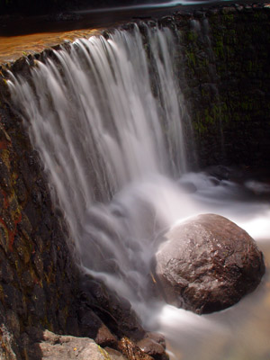
A crater lake is a lake that forms in a volcanic crater, caldera, or maar. Incoming precipitation fills the depression to form a deepening lake, until an equilibrium is reached between the rate of water coming in and the rate of water loss due to evaporation, subsurface drainage, and possibly also surface outflow if the lake fills the crater up to the lowest point on its rim.
Açores Lanscapes
|
|
Crater lakes covering active (fumarolic) volcanic vents are often known as volcanic lakes, and the water within them is typically acidic, saturated with volcanic gases, and cloudy with a strong greenish colour. Lakes located in dormant or extinct volcanoes tend to have fresh water, and the water clarity in such lakes is often exceptional due to the lack of inflowing streams and sediment. However, although picturesque, they can also be deadly due to gas discharges e.g. gas discharges from Lake Nyos suffocated 1,800 people in 1986.
A well-known crater lake, which bears the same name as the geological feature, is Crater Lake in Oregon, USA. It is located in the caldera of Mount Mazama, hence the name "Crater Lake" is somewhat of a misnomer. It is the deepest lake in the United States with a depth of 594 m (1,949 ft). Crater Lake is fed solely by falling rain and snow, with no inflow or outflow at the surface, and hence has the clearest water of any lake in the world.
Lakes can also fill impact craters (e.g. Manicouagan in Quebec, Lake Bosumtwi in Ghana and Siljan in Sweden), but these are not usually referred to as crater lakes except in a few isolated cases.
The highest volcano in the world, 6,893 metres (22,615 ft) Ojos del Salado, has a permanent crater lake about 100 metres (300 ft) in diameter at an elevation of 6,390 m (20,960 ft) on its eastern side. This is most likely the highest lake of any kind in the world.
Due to their unstable environment, some crater lakes exist only intermittently. Caldera lakes in contrast can be quite large and long-lasting; for instance, Lake Toba formed after its eruption around 70,000 years ago and has an area of over 1,000 square kilometres.
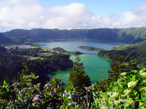
Although many of these crater lakes are well known throughout the world, the Azores Archipelago, situated approximately 1500 km from the Portuguese mainland can also boast a magnificent Crater lake: Sete Cidades!
Sete Cidades ("Seven Cities") is one of the most beautiful natural settings in the Azores, composed of two lakes in the center of a volcanic crater about three miles across. Located on the west side of São Miguel Island, it is the most popular national park in the islands. The direction of the lake as of the photo runs from northeast to southwest and is 5 km in length and about 1 to 2 km in width. This volcano is one of the most active in the Azores in the last 5,000 years.
Lake characteristics: Max. length 4.2 km; Max. width 2.0 km; Surface area 4.35 km²; Max. depth 33 m
Looking from the edge of the crater to the lakes some 500 m (1,500 ft) below, one lake looks blue (reflecting the sky) and is called Lagoa Azul (Blue Lagoon) and the other appears green (reflecting the surrounding ground) and is named Lagoa Verde (Green Lagoon). According to a legend, the differently coloured lakes were created when a princess and her lover, a young shepherd, had to part from each other. The tears they shed at their farewell became the two lakes, with the water coloured like their eyes.
|

The Bridge |
The two caldera lakes are one of the scenic highlights of the Azores. Since the first eruption about 20,000 years ago, 20 post-caldera eruptions have formed the 500 meters deep caldera walls. At the floor of the caldera six Holocene pyroclastic cones are located. A large group of pleistocene post-caldera trachytic lava domes, lava flows, and pyroclastic-flow deposits is found on the western-to-northern flanks. The most recent eruptions date to the 15th century. These eruptions occurred within the caldera and from submarine vents at the west coast of the island. There have been 4 Strombolian eruptions and 3 Surtseyan eruptions in history within a short distance of the shoreline.
The Sete Cidades volcano (São Miguel, Azores) is situated at the eastern end of the ultraslow spreading Terceira rift axis. The volcano comprises several dominantly basaltic pre-caldera eruptions, a trachytic caldera-forming stage and a post-caldera stage consisting of alternating trachytic and basaltic eruptions. The post-caldera flank lavas are more primitive (>5 wt % MgO) than the pre-caldera lavas, implying extended fractional crystallization and longer crustal residence times for the pre-caldera, shield-building lavas. Thermobarometric estimates show that the ascending alkali basaltic magmas stagnated and crystallized at the crust–mantle boundary ( 15 km depth), whereas the more evolved magmas mainly fractionated in the upper crust ( 3 km depth). The caldera-forming eruption was triggered by a basaltic injection into a shallow trachytic magma chamber. Lavas from all stages follow a single, continuous liquid line of descent from alkali basalt to trachyte, although slight differences in incompatible element (e.g. Ba/Nb, La/Nb) and Sr isotope ratios imply some heterogeneity of the mantle source. Major and trace element data suggest similar partial melting processes throughout the evolution of the volcano. Slight geochemical differences between post- and pre-caldera stage lavas from the Sete Cidades volcanic system indicate a variation in the mantle source composition with time. The oxygen fugacity increased from the pre-caldera to the post-caldera stage lavas, probably as a result of the assimilation of crustal rocks; this is supported by the presence of crustal xenoliths in the lavas of the flank vents. The lavas from the Sete Cidades volcano generally have low Sr isotope ratios; however, rocks from one post-caldera vent on the western flank indicate mixing with magmas resembling the lavas from the neighbouring Agua de Pau volcano, having higher Sr isotope ratios. The different magma sources at Sete Cidades and the adjacent Água de Pau volcano imply that, despite their close proximity, there is only limited interaction between them.
More Açores Lanscapes
The EarthcacheThis EarthCache takes to the bridge that separates the Lagoa Azul from the Loagoa Verde. On this bridge you have to perform two tasks:
1- What is the name of this bridge? And,
2- What type of stone is used to build the side protection walls of this bridge?
Send me the answers via my geocaching profile and enjoy your visit.
(visit link) (visit link)
BEIER C, HAASE KM and HANSTEEN TH (2006). Magma Evolution of the Sete Cidades Volcano, São Miguel, Azores. Journal of Petrology 47(7):1375-1411
E-mail me the answer and the image to ffortes@ptero.com .
A special thanks to DanielOliveira who have contributed to this EarthCache. You can visit his notable EarthCache work in:
http://www.geocaching.com/seek/nearest.aspx?tx=c66f5cf3-9523-4549-b8dd-759cd2f18db8&u=danieloliveira