The Furnas Fumarole Field EarthCache
The Furnas Fumarole Field
-
Difficulty:
-

-
Terrain:
-

Size:  (other)
Please note Use of geocaching.com services is subject to the terms and conditions
in our disclaimer.
The Furnas Fumarole Field - S. Miguel (Azores)
Introduction:
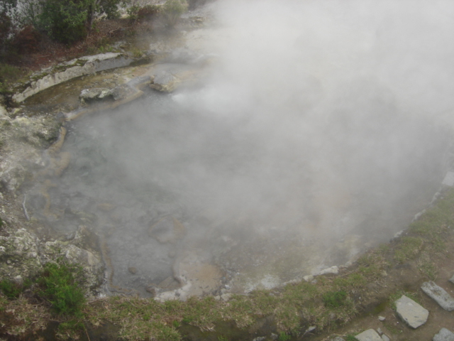
A fumarole (Latin fumus, smoke) is an opening in Earth’s crust, often in the neighbourhood of volcanoes,  which emits steam and gases such as carbon dioxide, sulphur dioxide, hydrochloric acid, and hydrogen sulphide. Fumaroles are commonly called by the word solfataras, from the Italian solfo, sulfur. The general public tends to use fumarole interchangeably with solfatara, unrelated to chemistry. Less commonly, the term mofette is used. Technically speaking, solfatara describes a steam vent rich in sulphuric compounds, such as sulphur dioxide or hydrogen sulphide, while moffetes are rich in carbon dioxide.
 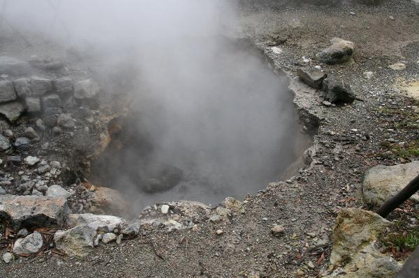 Fumaroles are not quiet geothermal features. They have been described as hissing, roaring, and even thundering. The sounds are dependent on the force of the steam being released into the atmosphere. Slowly diffusing emissions will have lessened sounds. Forceful, blasting emissions produce greater sounds. Fumaroles can occur on the surface of lava flows and thicker pyroclastic flows. The flows require a release of heat to cool off. Small cracks and crevices in the crust also allow steam from deeper within the Earth to escape. Fumaroles can be present singularly or in large fields full of them. Fumaroles are common globally wherever volcanism is occurring.
Depending on the heat source, fumaroles can be short or long term feature, ranging anywhere from weeks to many hundreds of years. The hotter the heat source is, whether it be an internal rock mass or a volcanic flow, the longer it will take to cool off, so the longer the fumarole will exist. A fumarole field is an area of thermal springs and gas vents where magma or hot igneous rocks at shallow depth are releasing gases or interacting with groundwater. From a simplistic point of view and the perspective of groundwater, fumaroles could be described as a hot spring that boils off all its water before the water reaches the surface.


Geological setting of the Furnas volcano:
Furnas is the easternmost of the three active central volcanoes on the island of São Miguel in the Azores. Unlike the other two central volcanoes, Sete Cidades and Fogo, Furnas does not have a well-developed edifice, but consists of a steep-sided caldera complex 8×5 km across. It is built on the outer flanks of the Povoação/Nordeste lava complex that forms the eastern end of São Miguel.
 Constructive flanks to the volcano exist on the southern side where they form the coastal cliffs, and to the west. The caldera margins tend to reflect the regional/local tectonic pattern which has also controlled the distribution of vents within the caldera and areas of thermal springs.
Activity at Furnas has been essentially explosive, erupting materials of trachytic composition. Products associated with the volcano include plinian and sub-plinian pumice deposits, ignimbrites and surge deposits, phreatomagmatic ashes, block and ash deposits and dome materials.
Most of the activity has occurred from 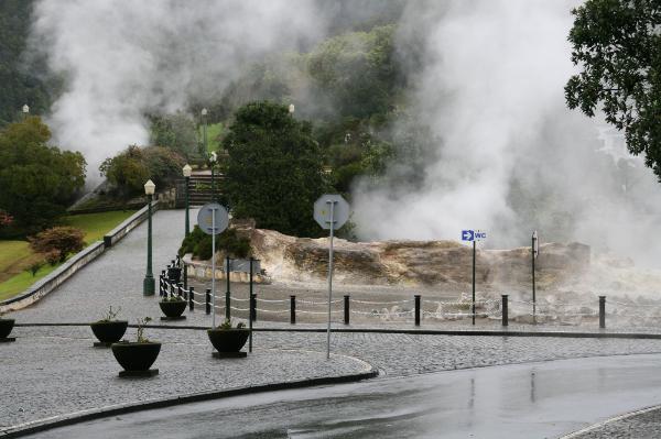 vents within the caldera, or on the caldera margin, although strombolian eruptions with aa flows of ankaramite and hawaiite have occurred outside the caldera. The eruptive history consists of at least two major caldera collapses, followed by caldera infilling. Based on 14C dates, it appears that the youngest major collapse occurred about 12,000–10,000 years BP.
New 14C dates for a densely welded ignimbrite suggest that a potential caldera-forming eruption occurred at about 30,000 years BP. Recent eruptions (<5000 years old) were mainly characterised by alternating episodes of magmatic and phreatomagmatic activity of plinian and sub-plinian magnitude, forming deposits of interbedded ash and lapilli. An historical eruption is documented in 1630 AD; new evidence suggests that another occurred during the early occupation of the area at about 1440 AD.
The cache:
To claim this EarthCache you need to perform two tasks.
Go to the given coordinates and tell me how many fumaroles are present here, if they emit steam and sound and what shape are their openings.
Optionally, take a picture of yourself near the tile panel at N37º 46.377' W025º 18.266 (78 m to the east of GZ), and incluede this photo in your log.
E-mail me the answers and I will get back to you with permission to log the cache. Attention: Only answers are accepted via e-mail profile, not accepted answers via new geocaching profile messages.
EarthCaching: Observe, learn, enjoy and be safe!
Refs:
Guest JE, Gaspar JL, Cole PD, Queiroz G, Duncan AM, Wallenstein, B, Ferreira T, Pacheco, JM (1999). Volcanic geology of Furnas Volcano, São Miguel, Azores. Journal of Volcanology and Geothermal Research 92 (1-2), pp.1-29.
 The most exciting way to learn about the Earth and its processes is to get into the outdoors and experience it first-hand. Visiting an Earthcache is a great outdooctivity the whole family can enjoy. An Earthcache is a special place that people can visit to learn about a unique geoscience feature or aspect of our Earth. Earthcaches include a set of educational notes and the details about where to find the location (latitude and longitude). Visitors to Earthcaches can see how our planet has been shaped by geological processes, how we manage the resources and how scientists gather evidence to learn about the Earth. To find out more click HERE.
Additional Hints
(Decrypt)
Nggragvba: Bayl nafjref ner npprcgrq ivn r-znvy cebsvyr, abg npprcgrq nafjref ivn arj trbpnpuvat cebsvyr zrffntrf.