Trees, What Trees? EarthCache
-
Difficulty:
-

-
Terrain:
-

Size:  (not chosen)
Please note Use of geocaching.com services is subject to the terms and conditions
in our disclaimer.
The Bisti/De-Na-Zin Wilderness Area was not always a barren high
desert; it was on the edge of an ancient inland sea with a forest,
swamp and rivers. It was thought that there were cypress-like
conifers and other plants towering as high as 200 feet.
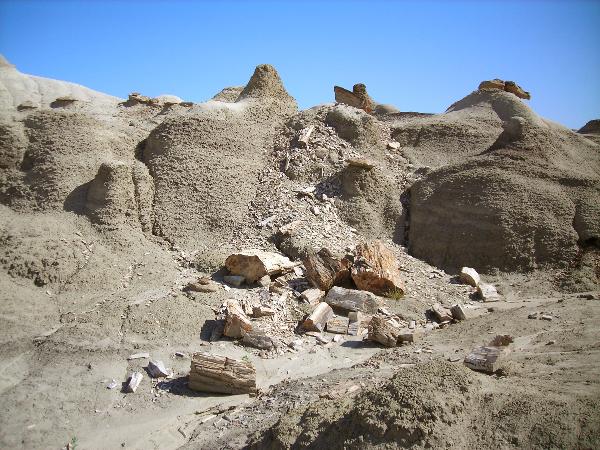
South of the Bisti/De-Na-Zin Wilderness Area a fossil forest has
been found and was so named because of the number of in situ
fossilized tree stumps and logs found there. The logs you see here
were more than likely washed down from the fossil forest and
deposited where they have set for millions of years.
Changes occurring in the earth’s climate during the
Cretaceous period, left remains of plants and animals buried in the
thick sediment of sandstone, mudstone, and shale of the Fruitland
and Kirkland Formation.
Creation of Petrified Wood:
Once a tree has fallen and is quickly covered by mud it will retain
its shape before the decay process begins. As the trees start to
decay, due to the anaerobic environment, volcanic ash with high
concentrations of silica and other minerals dissolved in the water
seep into the cells of the tree. As the water evaporates the
minerals replace the cells of the tree making it look like the
original tree, however heavier. Petrified wood weighs about 150
pounds per cubic foot and is considered one of the harder minerals,
being rated between 7 and 8 on the Moh’s Hardness
Scale.
Colors of Petrified Wood:
The color of petrified wood does not come from the wood itself but
from the minerals that were in the water and mud during the
petrifaction process.
Copper – green/blue
Cobalt – green/blue
Chromium – green/black
Manganese – pink
Carbon – black
Iron Oxides – red, brown, yellow
Manganese Oxides – black
Silica – white, grey
The Bisti/De-Na-Zin Wilderness Area is open year round, however the
temperatures can be extreme during the summer and the roads and
area can be impassable during rains, as the ground can become
slippery and leaves footprints that can take years to
disappear.
There are no developed trails or signs and you are encouraged to
discover the wonders of the wilderness. Exploring the many carved
out enclaves leading from the washes allows the opportunity to
experience solitude and a primitive type of recreation.
The area is closed to motorized vehicles and mechanical forms of
transportation (mountain bikes included). Also prohibited are
campfires, collecting fossils or petrified wood, climbing on
delicate geologic features, traveling in groups of more than eight
people, and trespassing on adjacent tribal lands.
Directions:
To reach the Bisti/De-Na-Zin Wilderness Area off NW 371, go south
about 36 ½ miles from the San Juan River crossing in Farmington and
take a left turn on to Road 7297 (not county maintained). Follow
the gravel road for about 2 miles to the Bisti parking lot. From
Crownpoint go north on NM 371 about 46 miles, just past the Don
Gleason Bridge over the De-Na-Zin Wash to the turn.
Topographic Maps for this area include: Alamo Mesa West, Alamo Mesa
East , Bisti Trading Post, and Tanner Lake.
Note: This Earthcache can be accomplished during the same trip
as “Bisti Badlands” (GC1NBCX)
, they are in the same general area.
Logging Requirements:
You will need to take a tape measure with you to answer one of the
questions.
The above coordinates will take you to a piece of petrified wood
more than a mile from the parking area. To log this
Earthcache:
1. Post a picture of you/your group exploring the area.
Please do not post any pictures of this piece of wood.
(Optional)
E-mail me the answers to these questions:
2. What may have made this piece of petrified wood the color
it is?
3. Can you count the growth rings on this piece of
wood?
4. How long is this log and what is the diameter?
5. The study of fossilized plants is called what (a little
internet searching will help)? (Optional as of January 1,
2011)
Be sure that you provide your e-mail address when you send the
answers to the above questions so that I can respond to your
answers faster. I will respond to all, as I feel it is an important
part of owning an Earthcache.
Other waypoints:
Turn Off from NM 371: 36 13.918 108 16.282
Parking Area: 36 15.736 108 15.173
References:
Bisti/De-Na-Zin Wilderness, Bureau of Land Management Wilderness
Area Northwest New Mexico Brochure
New Mexico Bureau of Geology & Mineral Resources, New Mexico
Institute of Mining & Technology,
http://geoinfo.nmt.edu/index.html
Petrified Wood: To Become Stoney,
http://www.earlham.edu/~tinkeem/web/petwood.htm
Sullivan, Robert M. 2006. Ah-shi-sle-pah Wilderness Study Area (San
Juan Basin, New Mexico): A paleontological (and historical)
treasure and resource. New Mexico Museum of Natural History and
Science Bulletin 34:169-174.
U. S. Department of the Interior Bureau of Land Management
Recreation Guidelines and Information:
http://www.nm.blm.gov/recreation/recreation_guidelines.htm
Wolberg, Donald L. and Bellis, Diane, Report of the regional
historical, stratigraphic, and paleontological framework of the
Late Cretaceous Fossil Forest locality near Split Lip Flats, San
Juan County, New Mexico
This Earthcache was placed with permission of the
Bureau of Land Management
Farmington Field Office
Congratulations to
kingbee on FTF!
Additional Hints
(No hints available.)