Komari vrch - tor Chuda nevesta a kamenne
more
Mosquito hills -
Mueckengipfel
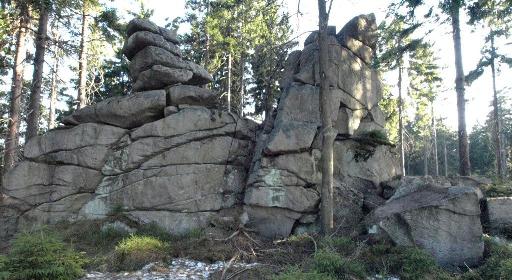
Komárí Vrch se nachází 4 km sv. od Kraslic, 2,5 km jv. od
Stríbrné. Jde o ojedinelý geologický útvar a horskou dominantu. Na
vrcholove plošine se nachází tor Chudá nevesta. Tory jsou
vetšinou menší izolovane skaly ohranicene ze vsech
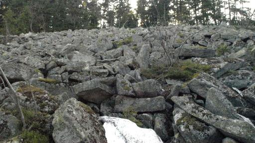
stran nad okolnim terénem. Asi 100 m východne od Chudé nevesty se
nachází kamenné more "Rachel", které je v této oblasti
nejrozsáhlejší. Kamenna more vynikla gravitaci a rozpadem
skalnich vychozu.
Prístup pro peší je z bývalé obce Nová Ves (nyní chatová
osada) , kde se dá zaparkovat (napr. zde N 50° 20.597 E 012°
32.586). Do Nové Vsi lze dojet autem z Kraslic smerem na Stríbrnou
(odbocka na N 50° 20.340 E 012° 31.257) Pozor posledních cca 300 m
jde už o polní cestu, radeji zaparkujte na konci asfaltove
silnice. Druhou možností je prístup z Rotavy , rovnež po
zelené turistické znacce k vrcholu a az zde odbocit. Od kese
"Komari vrch - Hrabeci skala jdete na vychod na podel kraje
vzrostleho lesa ."
[DE] Muckengipfel befindet sich cira 4 km von Kraslice und 2,5
km sudwestlich von Stribrna. Auf der Gipfelebene befindet sich
sogenanntes "Tor" Arme Braut. Tore sind kleine begrenzte Felsen.
Etwa 100 m von Arme Braut befindet sich das Steinmeer "Rachel", das
in diesem Gebiet das grosste ist. Die Steinmeeren entstanden durch
Gravitation und Zerlegung der Felsen. Sie konen in ehemeiligem Dorf
Nová ves parken (z. B. hier N 50° 20.597 E 012° 32.586). Nach Nová
ves kann man mit Auto aus Kraslice in der Richtung Stribrna fahren
(Ableitung auf N 50° 20.340 E 012° 31.257). Achtung die letzten 300
m ist hier nur Feldweg, parken sie lieber am ende des
Asphaltweges.
[EN] Mosquito hills are situated circa 4 km from Kraslice and
2,5 km southwest from Stribrna. There is a so called "tor" Poor
Bride at the shelf on the top of the hill. Tors are small bordered
rocks. There is a stone sea named "Rachel" about 100 m from the
tor. Stone seas rised from gravitation and breakdown of rocks. You
can park in ex-village Nová ves (e.g. here N 50° 20.597 E 012°
32.586). You can go to Nová ves by car from Kraslice towards
Stribrna (turning at N 50° 20.340 E 012° 31.257). Watch out, there
is a cartway the last 300 m, you should park at the end of the
asphalt road.
Tato kes je urcena pouze k vymene CWG , GC
a TB . Obsahuje specialní CWG "Komári vrch" . Vymenujte prosím
1:1
Cache is established only for CWG,GC and TB
exchange. Dieser Cache ist nur fur CWG, GC und TB Auswechlung
bestimmt.
