|
Geocache version: 1.1 [10.01.2010]
|
Listing version: 2.1 [12.08.2010]
|
Last owner maintenance: [29.10.2010]
|

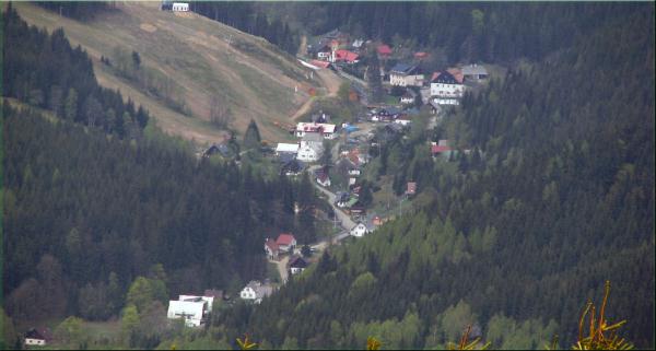
Petrikov je osada lezici v
severni casti Olomouckeho kraje v okrese Jesenik. Je soucasti obce
Ostruzna a lezi v 740-950 m.n.m. Petrikov byl zalozen roku 1617
jako tezebni oblast pyritu a tuhy. V roce 1677 zde bydlelo 12
obyvatel. V roce 1900 jich bylo jiz 207. Pri poslednim scitani,
ktere bylo roku 1991, bylo zjisteno 16 osob v 5ti trvale obydlenych
domech.
Ve druhe polovine 19. stoleti zde fungovala jedina vyrobna
zinkovych barev v tehdejsim Rakousko-Uhersku. Zdejsi rozlehle lesy
byly majetkem Kolstejnskeho velkostatku. V mezivalecnem obdobi
pecoval o 900 hektaru lesa statni revir. V roce 1854 zacalo
skolni vyucovani v soukromych domech v Petrikove a
v roce 1915 zde byla postavena skolni budova. K nemeckym
skolam v obou vesnicich pribyly po roce 1918 ceske mensinove
skoly, ale po roce 1938 byly uzavreny. Dnes uz tu zadna skola
nestoji.
Dalsi zajimavosti je mistni kostelicek, ktery je zasvedcen svatemu
Vavrincovi a nedavno oslavil krasne kulatiny.
V zimnim obdobi je zde denne nekolikatisicova navstevnost, protoze
Petrikov patri k velmi atraktivnim zimnim strediskum.
V zimni sezone je do obce zakaz vjezdu. Parkovat lze tedy na
souradnicich:
N 050°11.749 E 017°03.158 .
Neco o samotne kesce
Startovni souradnice Vas
zavedou na zacatek vesnice, kde si opiste nadmorskou vysku
ABC obce Petrikov. Pokracujte dale do vesnice, kde
si zapiste pocet kmenu stromu D tvorici "vstupni
branu". Dale projdete vesnicku temer az nakonec, kde po leve strane
uvidite kostelicek. Nad jeho vstupem je uveden letopocet
EFGH kdy byl postaven. Jiz jste temer na konci
vesnice. Doporucuji si ji projit az do konce, mozna Vas tam ceka
nejake prekvapeni.
Cilove souradnice spocitate pomoci vzorecku:
N 50° I.J'
E 17° KL.M'
I=A+B
J=(F*A*B*D)-(A*C+B)*7
K=G*F
L=A-C+E
M=J+(C*D)-(H+E)
Ke kesce se prosim chovejte opatrne, at tam vydrzi i pro dalsi
kacery. Diky a preji hodne radostnych zazitku pri
geocachingu.

The village of Petrikov lies
in the north part of the region of Olomouc, in the district of
Jesenik. It is a part of the village of Ostružná and it lies
in 740-950 metres above the sea level. Petrikov was found in 1617
as a mining area of pyrite and graphite. In 1677 it had 12
inhabitants. In 1900 there already were 207 inhbitants. With The
last population census which was held in 1991 there were 16 people
living in 5 permanently inhabited houses.
In the second part ot the 19th century there was the only
manufactory of zink paint in Austria-Hungary at that time. The
great local forrests belonged to the possessions of the Kolstejn
manor. In the interwar Period state foresters took care of these
900 hectares of forrests. The first school education was organised
in private houses in Petrikov in 1854 and in 1915 the first school
building was built there. Except the two German schools in both
villages there were also Czech minority schools built in 1918 But
after 1938 they were shut down. There is not any school there
nowadays. Another matter of interest is the local chapel which is
devoted to St. Lawrenc and recently there is an important
anniversary of the foundation of the chapel.
In winter thousands of people visit Petrikov every day, because it
is one of the most attractive ski resorts.
In winter it is banned to go to the village by car, so you can park
your car at these coordinates: N 050°11.749 E 017°03.158
.
About cache
The starting coordinates
will take you to the beggining of the village where you can copy
the altitude (the elevation above the sea level)
ABC of Petrikov. Continue walking towards the
village where you should note down the number of tree trunks
D which create the entrance gateway of the
willage. Then you go through the village almost to the end, where
there is a chapel on the left side. There is a date of the
foundation of the chapel EFGH written above the
entrance. You are now almost at the end of the village. I highly
recommend you to go to the end, there may be a surprise for
you.
You can work out the final coordinates according to this
figure:
N 50° I.J'
E 17° KL.M'
I=A+B
J=(F*A*B*D)-(A*C+B)*7
K=G*F
L=A-C+E
M=J+(C*D)-(H+E)
Please be careful with the cache so that it lasts for other
cachers. Thank you and have a wonderfull time when
geocaching.
__________________________________________________________________________

|