IATCC - BO-DE-WAD-ME Cuesta
Type of Land:
Wisconsin State Park - Potawatomi
The park is open 365 days per year; a Wisconsin state park sticker is required. The road to the Observation Tower is not plowed during the winter; may need to park at the bottom of the hill. Pets are allowed on a leash.
Terrain:
There are some steep elevation changes with timber or stone steps; probably couldn't ride a bike up, but could push or carry it up.
Description of Area:
Follow park directional signs to the Observation Tower
The Trailhead is near the Observation Tower near the north end of the park.
The Eastern Terminus of the Ice Age Trail is located near the Observation Tower with the Tower / Ice Age Trailhead sign to the south of the road and parking area.
Suggested Equipment and Supplies:
Tape measure or other method of measuring height
GPS Unit
GPS Coordinates: (updated after September 2023 Ice Age Trail Alliance trailbuilding project)
Parking - N44 52.473 W087 25.921 (Eastern Terminus Parking)
Site Point A - N44 52.394 W087 25.168 (Bench at the top of the steps)
Site Point B - N44 52.406 W087 25.143 (bottom of steps)
Site Point C - N 44 52.400 W087 25.079 (bottom of "cliff")
Site Point D - N 44 52.325 W087 25.032 (along the Sturgeon Bay shoreline)
Educational Information:
BO-DE-WAD-ME, which means "Keeper of the Fire," is the name of the Indian tribe that inhabited the area when the Europeans arrived. Eventually the spelling and pronunciation were changed to Potawatomi.
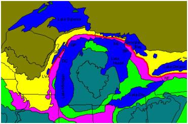
A cuesta is a short steep slope over the exposed edges of rock layers with a long gentle slope in the opposite direction. The Niagara Escarpment is a cuesta that runs westward from New York State, through Ontario, to Wisconsin; then south through Wisconsin and Illinois. The diagram below shows the Niagara Escarpment in pink.
The formation of the Niagara Escarpment began 430 - 450 million years ago. A depression in the earth's crust (present day Lower Michigan) formed a shallow sea. Sand, silt, and clay flowing into the ancient sea eventually compressed into layers of soft shales and sandstone. Sea life also caused an accumulation of lime-rich organic material from decomposing shells and skeletons. These layers compressed into layers of resistant "dolostone," which is similar to limestone, but also contains magnesium.
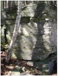
Rock exposures and drill holes demonstrate that the escarpment is not a fault line. It has a cap rock of dolostone which is more resistant to erosion than the underlying shale and sandstone. Millions of years of differential erosion exposed the outer rim of the saucer-shaped depression of the ancient sea.
The erosion was caused by wind, water, and glacier ice. The glacier also carried and deposited huge masses of sand, clay, and stone which buried and concealed the escarpment in many places south of the Door Peninsula. Another section of the Niagara Escarpment that has been exposed can be found in the Southern Kettle Moraine State Forest. That section is also a ColdCache site called "The Niagara Escarpment - Brady's Rock." (GC150BF)
In order to log this EarthCache as a find the following tasks must be completed:
1. Count the number of steps between site points A and B; along trail between trailhead at the Observation Tower and Shore Road.
2. Estimate the height and count the number of layers in the exposed cliff near site point C; at the bottom of the cliff between Shore Road and the Sturgeon Bay shoreline.
3. Count the number of layers in the exposed cliff near the site point D; about 1/8 mile along the shoreline from site point C
Please email the answers to me via my profile on the cache page.
 IATCC is the cache designation to highlight a series of EarthCaches along the Ice Age National Scenic Trail grouped into a special category called "ColdCache."
The Ice Age Trail is one of eleven National Scenic Trails designated by the National Park Service. This unique trail is entirely within the state of Wisconsin and follows along the terminal moraine of the most recent glacier which retreated about 10,000 years ago.
This project is supported by the Ice Age Trail Alliance (IATA). The goal is to bring more visitors to the trail and promote public awareness, appreciation, and understanding of Wisconsin’s glacial landscape.
The IATA has created an awards program to encourage visits to the trail and ColdCache sites. This awards program is separate from, and in addition to, any other Geo- or EarthCache awards program.
A current list of approved ColdCache sites can be found on the “IATCC Bookmark List”. More information on the Ice Age Trail Atlas, the Companion Guide, the ColdCache Project and Awards Program can be found on the “ColdCache Webpage”
The Geocache Notification Form has been submitted to Don McKinnon. Geocaches placed on Wisconsin Department of Natural Resource managed lands require permission by means of a notification form. Please print out a paper copy of the notification form, fill in all required information, then submit it to the land manager. The DNR Notification form and land manager information can be obtained at: http://www.wi-geocaching.com/modules.php?name=Wiki&pagename=Hiding%20A%20Cache