
 This feature can be viewed from a pullout along the paved portion of Soda Lake Road in the southern end of the Carrizo Plain. No off road vehicle travel is allowed to reach the site. Collection of plants, rocks, or any artifacts is prohibited. If turning around, stay within the road bed and do not go into the field. Practice Leave No Trace principles.
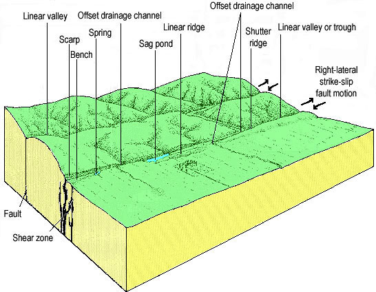
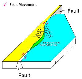 The San Andreas Fault is not a perfectly straight line nor is it always a single fault. In some areas it is made up of a number of parallel fault strands. The combination of these multiple strands and non linear fault lines form blocks of rocks that are pushed up and down relative to each other depending on how the faults on either side of the block are moving.
Here a block has fallen down relative to the surrounding blocks, forming a depression. During the wet season water accumulates in it forming a pond and during the dry season the water evaporates. The white material is salt that has dissolved from the surrounding hillsides and accumulated in the pond as the water is evaporated during the dry season.
 Logging requirements:
Send me a note with :
- The text "GC1VKB9 Carrizo Plain Sag Pond (one of many)" on the first line
- The number of people in your group.
- Relative to the road, describe the length and width of the pond.
- Based on that, what direction is the San Andreas going at this location?
The following sources were used to generate this cache:
- David K. Lynch 2006, field guide to the San Andreas Fault, Thule Scientific, Topanga, CA
- Robert E. Wallace Ed. The San Andreas Fault System, California U.S. GEOLOGICAL SURVEY PROFESSIONAL PAPER 1515, 2. GEOMORPHIC EXPRESSION http://3dparks.wr.usgs.gov/pp1515/chapter2.html
- http://3dparks.wr.usgs.gov/haywardfault/html/glossary.html#geomorph
Placement approved by the Carrizo Plains National Monument